Phuket (/puːˈkɛt/; Thai: ภูเก็ต[pʰūː.kèt]), formerly known as Thalang (Tha-Laang) and, in Western sources, Junk Ceylon (a corruption of the Malay Tanjung Salang, i.e. "Cape Salang"), is one of the southern provinces (changwat) of Thailand. Neighbouring provinces are (from north clockwise) Phang Nga and Krabi, but as Phuket is an island it has no land boundaries.
Phuket, which is approximately the size of Singapore, is Thailand’s largest island. The island is connected to mainland Thailand by two bridges. It is situated off the west coast of Thailand in the Andaman Sea. Phuket formerly derived its wealth from tin and rubber, and enjoyed a rich and colorful history. The island was on one of the major trading routes between India and China, and was frequently mentioned in foreign ship logs of Portuguese, French, Dutch and English traders. The region now derives much of its income from tourism.
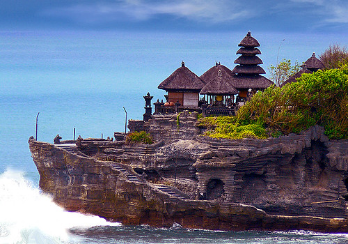
Tanah Lot is a rock formation off the Indonesian island of Bali. It is home of a pilgrimage temple, the Pura Tanah Lot (literally "Tanah Lot temple") and a popular tourist and cultural icon for photography and general exoticism.
Pura Tanah Lot (Tanah Lot Temple) is Hindu Temple.
Located about 20 km from Denpasar, the temple sits on a huge offshore rock which has been shaped continuously over the years by the ocean tide.
Tanah Lot means "Land in the Middle of the Sea" (in Balinese language) is a famous rock formation off the Indonesian island of Bali.
Note: It is a fantastic place to view beautiful dramatic sunsets. Every day at dusk, tourists throng the area to witness the magnificent silhouette of the temple against the glowing horizon.
more: @
The city of Manila (Filipino: Lungsod ng Maynila) is the capital of the Philippines and one of the 16 cities and a municipality that makes up the Manila metropolitan area, the National Capital Region of the Philippines, which is one of the most populous urban areas in the world. It is located on the eastern shores of Manila bay, on the western side of the island of Luzon. With a population of 1,660,714 Manila is the second most populous city in the Philippines behind only neighboring Quezon city. The city's inhabitants, however, inhabit an area of only 38.55 square kilometers, making Manila not only the most densely populated city in the Philippines but also the most densely populated city in the world.
The city is divided into six legislative districts and consists of sixteen geographical districts: Binondo, Ermita, Intramuros, Malate, Paco, Pandacan, Port Area, Quiapo, Sampaloc, San Andres, San Miguel, San Nicolas, Santa Ana, Santa Cruz, Santa Mesa and Tondo. Within their precincts can be found areas of bustling commerce and some of the most historically and culturally significant iconic landmarks in the country as well as the seat of the executive branch of the government. It is home to many scientific and educational institutions, as well as numerous sport facilities. Manila is a major political, commercial, cosmopolitan, cultural, educational, religious, and transportation center of the Philippines.
Manila is bordered by several cities of the Manila metropolitan area: Navotas and Caloocan cities to the north, Quezon city to the northeast, San Juan and Mandaluyong cities to the east, Makati city to the southeast, and Pasay city to the south.
The earliest written accounts of the city date back to the Spanish era which describe a native settlement already existing in the area when the Spanish first arrived. Manila eventually became the center of Spanish activity in the Far East and one end of the Manila–Acapulco galleon trade route leading to it being called the "Pearl of the Orient". Later it saw the arrival of the Americans who made contributions to the city's urban planning and development only to have most of those improvements lost in the devastation of World War II. Since then the city has been rebuilt.
Manila has been a popular tourist attraction which attracted over 1 million tourist annually. Most well-known landmarks in the Manila metropolitan area lies within the city such as the Rizal Park and the Manila Ocean Park. Historical structures such as the Fort Santiago lies within Intramuros, one of Manila's popular tourist attractions.
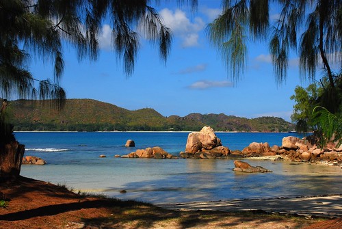
Praslin is the second largest island (38 km²) of the Seychelles, lying 44 km north east of Mahé. Praslin has a population of around 6,500 people and comprises two administrative districts; Baie Sainte Anne and Grand' Anse (Praslin). The main settlements are the Baie Ste Anne, Anse Volbert and Grand' Anse.
It was named Isle de Palmes by explorer Lazare Picault in 1744. During that time it was used as a hideaway by pirates and Arab merchants. In 1768 it was renamed Praslin in honor of French diplomat César Gabriel de Choiseul, duc de Praslin.
Praslin is known as a tourist destination with several hotels and resorts, as well as a number of beaches such as Anse Lazio and Anse Georgette. It also has substantial tracts of tropical forests with birds such as the endemic Seychelles Bulbul and the Seychelles Black Parrot. The beautiful Vallée de Mai Nature Preserve is known for the unique coco de mer and vanilla orchids. It has been reported that General Charles George Gordon of Khartoum (1833-1885) was convinced that Vallée de Mai was the Biblical "Garden of Eden".
Praslin is home to Praslin Island Airport, while surrounding islands include Curieuse Island, La Digue, Cousin Island, Cousine Island and Aride Island. There are also a few near offshore islets including Round Island (.193 km²) and Chauve Souris (.007 km²); both of which have hotel accommodations.
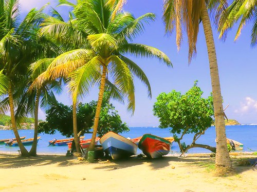
Martinique is an island in the eastern Caribbean Sea, with a land area of 1,128 km2 (436 sq mi). It is an overseas region of France, consisting of a single overseas department. To the northwest lies Dominica, to the south St Lucia, and to the southeast Barbados. As with the other overseas departments, Martinique is one of the twenty-six regions of France (being an overseas region) and an integral part of the Republic.
As part of France, Martinique is part of the European Union, and its currency is the euro. Its official language is French, although many of its inhabitants also speak Antillean Creole (Créole Martiniquais). Martinique is pictured on all euro banknotes, on the reverse at the bottom of each note, right of the Greek ΕΥΡΩ (EURO) next to the denomination.
Diamond Rock (Rocher du Diamant) is a 175 meter (574 feet) high basalt island located south of Fort-de-France, the main port of the Caribbean island of Martinique.
The uninhabited island is about three kilometers from Pointe Diamant. The island gets its name from the reflections that its sides cast at certain hours of the day, which evoke images of a precious stone. Its claim to fame is the role that it played in the Napoleonic Wars.
The rock is a volcanic plug, a remnant of the strong volcanic activity that affected the region some one million years ago.
However, a Captain Hansen of the Norwegian steamship Talsiman reported that on 13 May, 1902, he observed what he took to be a volcanic eruption from a hole in the rock. This was at the time of the devastating volcanic eruption Mount Pelée that destroyed Saint-Pierre. Hansen did not investigate further.
Like the other 47 islets that circle Martinique, the Rock has its own ecological characteristics. It is sunnier than the main island, drier, and subject to a long seasonal dry period. Today it is covered in undergrowth and cacti.
Relatively inaccessible and inhospitable, the island is uninhabited, which has permitted it to remain a sanctuary for a species that had been believed to be extinct.
A nature survey has suggested that Diamond Rock is probably the last refuge for a species of reptile once endemic to Martinique, the Couress grass snake (Liophis cursor).
Below water the Diamond Rock cavern, a deep triangular cave, is a popular attraction for scuba divers. The cave is said to contain prolific quantities of beautiful sea fans and corals, though strong currents make diving the island a risky venture.
The author John Fine reports that while diving he found one of the Rock's cannon that the French had toppled from the summit.
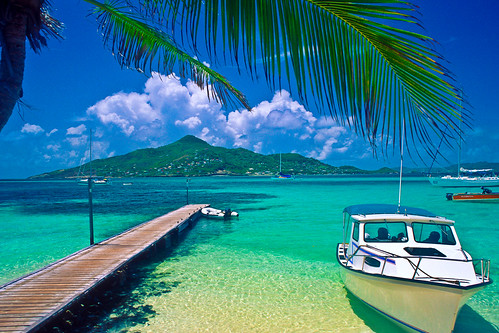
Petit St. Vincent, known locally as PSV, is an island 40 statute miles (60 km) south of St. Vincent in the Grenadine islands. It consists of softly rolling hills spread over 113 acres (46 ha) surrounded mostly by two miles (3 km) of white sand beaches.
The island is privately owned. In the 1960s, friends Hazen Richardson and Douglas Terman discovered the island while sailing, and conceived the idea of making it an exclusive resort. Richardson oversaw the construction of the resort and operated it for 40 years; Terman went on to become a novelist.
PSV consists of 22 cottages and a central dining room, with staff housing and other support structures. It is a resort for a particular kind of person; the cottages are not air-conditioned, and have neither televisions nor telephones. However, the food, service, and other amenities are of a very high quality. Guests can take all meals in their cottages, and are otherwise guaranteed total privacy should they wish it.
Owner Haze Richardson died in a swimming accident in Costa Rica on Saturday February 2, 2008. His wife, Lynn Richardson, plans to continue managing the resort.
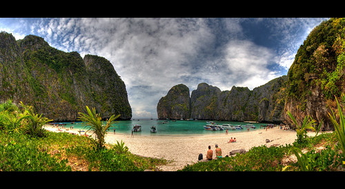
Ko Phi Phi Leh (or Ko Phi Phi Ley) is an island of the Phi Phi archipelago, in the Andaman Sea. It belongs to the Krabi province of Thailand.
Mahya Bay (or Maya Bay) is popular for diving, and has become even more popular after the 2000 movie The Beach was filmed there. According to the Lonely Planet's Thailand guidebook, the 2004 tsunami dramatically improved the look of Maya Bay. This was due to the fact that the high waves had cleaned up the beach and removed all the landscaping the Fox production team had added.
Controversy arose during the making of the film The Beach due to 20th Century Fox bulldozing and rescaping of the natural beach setting of Ko Phi Phi Leh to make it more "paradise-like". The production altered some sand dunes and cleared some coconut trees and grass to widen the beach. Fox set aside a fund to reconstruct and return the beach to its natural state, however lawsuits were filed as many believed the damage to the ecosystem is permanent and restoration attempts failed.
The lawsuits dragged on for years. In 2006, Thailand's Supreme Court upheld an appeal court ruling that the filming had harmed the environment and ordered that damage assessments be made. Defendants in the case included 20th Century Fox and some Thai government officials.
Prior to 2004, the island had avoided development. However, it is now a part of Phi Phi National Park and has since begun to see the beginnings of development and some clearing of natural plant life. There are current plans to build bungalows on the island and as of 2004 an entry-fee of 40 Baht has been charged; as of February 2007 the charge for private visitors has been raised to Bt200 per person. There are now permanent basic facilities on the island - toilets, a snack bar and camping sites.
Honolulu is the capital and most populous census-designated place (CDP) in the U.S. state of Hawaii. Although Honolulu refers to the urban area on the southeastern shore of the island of Oahu, the city and the county are consolidated, known as the City and County of Honolulu, and the city and county is designated as the entire island. The City and County of Honolulu is the only incorporated city in Hawaii, as all other local government entities are administered at the county level. The population of the census designated place was 371,657 at the 2000 census, while the population of the City and County was 909,863. In the Hawaiian language, Honolulu means "sheltered bay" or "place of shelter." =====================================================
Η Χονολουλού είναι η πρωτεύουσα και η πολυπληθέστερη κοινότητα της Χαβάης, στις Ηνωμένες Πολιτείες. Στα χαβανέζικα χονολούλου σημαίνει «προστατευμένος κόλπος» ή «τόπος προστασίας». Την 1η Ιουλίου 2004, σύμφωνα με το Γραφείο Απογραφής Πληθυσμού των ΗΠΑ, η Χονολουλού υπολογίστηκε ότι είχε 377.260 κατοίκους, ενώ η πόλη μαζί με την κομητεία (ουσιαστικά το νησί Οάχου) 900.000. Στη Χαβάη η τοπική διοίκηση υφίσταται μόνο σε επίπεδο κομητείας, και έτσι η πόλη και κομητεία της Χονολουλού επεκτείνεται σε όλο το νησί Οάχου.
H Δομινικανή Δημοκρατία είναι μια ισπανόφωνη αντιπροσωπευτική δημοκρατία, που συνορεύει με την Αϊτή και καταλαμβάνει τα ανατολικά 2/3 του νησιού Ισπανιόλα στην Καραϊβική. Έχει έκταση 48,730 km² και πληθυσμό 8,895,000.Πρωτεύουσά της είναι ο Άγιος Δομίνικος ,αλλιώς Σάντο Ντομίνγκο. Αποσχίστηκε από την Αϊτή και έγινε ανεξάρτητο κράτος το 1844. H Δομινικανή Δημοκρατία συνορεύει με την Αϊτή στα δυτικά, ενώ βρέχεται από τον Ατλαντικό Ωκεανό και στα νότια από την Καραϊβική Θάλασσα. Καταλαμβάνει τα δύο τρίτα από το ανατολικό τμήμα του νησιού Ισπανιόλα. Το υψηλότερο σημείο της είναι η Πίκο Ντουάρτε, στην Κεντρική Κορδιλιέρα, με υψόμετρο 3.175 μ. Στα ανατολικά υψώνεται η χαμηλότερη ανατολική Κορδιλιέρα, με τη μεγάλη πεδιάδα Λιάνο δε Σέιμπο. Η Βόρεια Κορδιλιέρα φτάνει σε ύψος τα 1.249 μ. Σημαντικότερος ποταμός είναι ο μεγαλύτερος σε μήκος, ο Γιάκε ντελ Νόρτε, ο οποίος ονομάστηκε "Ποταμός του Χρυσού" εξαιτίας της ύπαρξης χρυσοφόρου άμμου σε ένα μέρος το ρου του. Η ανακάλυψη έγινε από το Χριστόφορο Κολόμβο.
Το κλίμα του κράτους είναι τροπικό, ωστόσο οι αληγείς άνεμοι ευθύνονται για τη διαφορετική κατανομή των βροχοπτώσεων . Επίσης, τα θερμά νερά από τα ρεύματα των Αντιλλών επηρεάζουν τις κλιματικές συνθήκες. Η χώρα προσφέρεται στους λάτρεις της οικολογίας. Στο ακρωτήριο Σαμανά, μπορεί κανείς να απολαύσει τα μαγκρόβια δάση και τα σπήλαια με τις βραχογραφίες στο εθνικό πάρκο που ευρίσκεται εκεί. Το Εθνικό Πάρκο Χαράγκουα βρίσκεται στα νοτιανατολικά των ακτών της χώρας. Εκεί, στα νησάκια Μπεάτα και Άλτο Βέλο ζουν ενδημικά πτηνά. Το νησί Καβρίτος, το οποίο βρίσκεται στη λίμνη Ερικίγιε, με πλούσια πανίδα, έχει ανακηρυχθεί προστατευόμενη περιοχή. Για καταδύσεις προσφέρεται το ακατοίκητο νησί Καταλίνα, το οποίο βρίσκεται στα ανοικτά της πόλης Λα Ρομάνα. Ανάμεσα στα αξιοθέατα της χώρας περιλαμβάνονται τα αποικιακά κτίρια και οχυρά, όπως το Σαν Λουίς στη Σαντιάγο δε Λος Καμπαγιέρος και ναοί, όπως ο καθεδρικός ναός του Σαντιάγο ελ Μαγιόρ.
Ξεχωριστό ενδιαφέρον παρουσιάζουν τα μουσεία, όπως το Αρχαιολογικό και Ανθρωπολογικό Μουσείο των Δομινικανών στην πρωτεύουσα Σάντο Ντομίνγκο, με τη μεγαλύτερη συλλογή του είδους σε ολόκληρη την Καραϊβική, το Λαογραφικό Μουσείο Τόμας Μορέλ, το Αρχαιολογικό Μουσείο με τα εκθέματα των αυτοχθόνων Τάινο και το Μουσείο Καπνού αλλά και τα νεοκλασικά σπίτια στη Σαν Πέδρο ντε Μακορίς. Αξίζει ακόμα να αναφερθούν και κάποια μνημεία που σχετίζονται με το Χριστόφορο Κολόμβο, ο οποίος και ανακάλυψε το νησί. Στη βόρεια ακτή της χώρας βρίσκεται η Λα Ισαβέλα, ο πρώτος οικισμός που ίδρυσε ο Γενουάτης θαλασσοπόρος στο Νέο Κόσμο, το 1494. Σήμερα στη θέση αυτή υπάρχει Ιστορικό Πάρκο, όπου εκτίθενται ευρήματα από τις ανασκαφές που διεξήχθησαν στο μέρος αυτό. Επίσης, ο Φάρος του Κολόμβου (1992) βρίσκεται στα ανατολικά της Δομινικανής Δημοκρατίας και αποτελεί ένα συγκρότημα διαμερισμάτων κατασκευασμένων από μπετόν.
Στο Φάρο, που χτίστηκε για να εορταστούν τα 500 χρόνια από το πρώτο ταξίδι του Κολόμβου στην Αμερική, εκτίθενται τέχνεργα από το πλοίο του θαλασσοπόρου, τη Σάντα Μαρία. Επίσης, εκεί μεταφέρθηκε το υποτιθέμενο λείψανο του Κολόμβου από τον καθεδρικό ναό του Σάντο Ντομίνγκο, τον Οκτώβριο του 1992. Σύμφωνα με την ισπανική εκδοχή, η σορός του Κολόμβου μεταφέρθηκε στη Σεβίλλη. Η Παλαιά Πόλη του Σάντο Ντομίνγκο ανακηρύχθηκε Μνημείο Παγκόσμιας Πολιτιστικής Κληρονομιάς από την ΟΥΝΕΣΚΟ το 1990. Άλλα σημαντικά μνημεία στην πρωτεύουσα της Δομινικανής Δημοκρατίας είναι οι ναοί του Αγίου Φραγκίσκου και του Αγίου Νικολάου (αμφότεροι του 16ου αιώνα), ο καθεδρικός Ναός της Σάντα Μαρίας λα Μενόρ του 16ου αιώνα (όπου , όπως πιστευόταν, φυλασσόταν το λείψανο του Χριστόφορου Κολόμβου), το Εθνικό Πάνθεον που χτίστηκε από τους Ιησουίτες το 18ο αιώνα, η Πλατεία Πολιτισμού, το Πανεπιστήμιο του 1538 (αρχαιότερο της αμερικανικής ηπείρου) και πλήθος άλλων.
ΚΟΥΖΙΝΑ Είναι μίξη Ισπανικής, Αφρικανικής και της τοπικής Ταϊνο. Δεν έχει μεγάλες διαφορές από την κουζίνα της καραϊβικής (Κρεολή),κλασικό πιάτο το "La Bandera" αποτελούμενο από πικάντικο κοτόπουλο με την συνοδεία ρυζιού και κόκκινων φασολιών. κλασικό καρύκευμα το sofrito, μίγμα από τοπικά φυτά και μπαχαρικά συνοδεύει σχεδόν όλα τα τοπικά φαγητά. Δοκιμάστε άφοβα τα τοπικά παραδοσιακά πιάτα όπως τα chicharrón, yucca ή casave την γνωστή σε μας Μανιόκα, και τα pastelitos. Δοκιμάστε την τοπική παραλλαγή του ρυζόγαλου (arroz con dulce), bizcocho dominicano, και φυσικά ζαχαροκάλαμο φρεσκοκομμένο. Δοκιμάστε τα ποτά Morir Soñando, ρούμι, μπύρα, Mamajuana, batida (μιλκ σέικ), ponche, mabí, και καφέ.
Επίσης εδώ ακούγεται και η Bachata, φολκλορική μουσική "λατινική μπαλάντα" την ονομάζουν και οι στίχοι μιλάνε συνήθως για θέματα που αφήνουν πίκρα , γι' αυτό την ονομάζουν και amarata.
Eνα πολύ όμορφο music-video απο τον SantoDomingoGuy στο YOUTUBE.
Μουσικοχορευτικές και καρναβαλικές εκδηλώσεις αφθονούν στη χώρα και στηρίζονται στη μερένγκε. Το Εθνικό Φεστιβάλ του εθνικού είδους μουσικής, που είναι η μερένγκε, διεξάγεται κάθε χρόνο, στα τέλη Ιουλίου με αρχές Αυγούστου.
 /puːˈkɛt/; Thai: ภูเก็ต [pʰūː.kèt]), formerly known as Thalang (Tha-Laang) and, in Western sources, Junk Ceylon (a corruption of the Malay Tanjung Salang, i.e. "Cape Salang"), is one of the southern provinces (changwat) of Thailand. Neighbouring provinces are (from north clockwise) Phang Nga and Krabi, but as Phuket is an island it has no land boundaries.


 travel



Pura Tanah Lot (Tanah Lot Temple) is Hindu Temple.
Located about 20 km from Denpasar, the temple sits on a huge offshore rock which has been shaped continuously over the years by the ocean tide.
Tanah Lot means "Land in the Middle of the Sea" (in Balinese language) is a famous rock formation off the Indonesian island of Bali.
Note: It is a fantastic place to view beautiful dramatic sunsets. Every day at dusk, tourists throng the area to witness the magnificent silhouette of the temple against the glowing horizon.
more: @