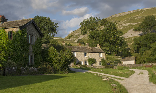
A sleepy little village clustered around a green with a Maypole, a little corner of paradise in the dales.
Conistone is a small village (population 117 in the 2001 census) in North Yorkshire, England. It lies 3 miles north of Grassington, beside the River Wharfe, in Upper Wharfedale.
The village is set in characteristic limestone scenery, including Mossdale Caverns, the dry gorge of Conistone Dib and the limestone outcrop of Conistone Pie. Above the Dib the Dales Way path connects Kettlewell, to its north, and Grassington, to its south, providing distant views over Wharfedale. From the B6160 road, the Wharfe is crossed at Conistone by a stone-arch bridge, which is within easy walking distance of Kilnsey, with its Crag.
The parish church, St Mary's Church, dates from the 11th or 12th century, and is a Grade II listed building.
Conistone was historically in the large ancient parish of Burnsall, in Staincliffe Wapentake in the West Riding of Yorkshire. It became part of the civil parish of Conistone with Kilnsey in 1866,[2] and was transferred to North Yorkshire in 1974.
Wednesday, August 28, 2013
Conistone, Yorkshire, England.
Blenheim Palace

Home to the 11th Duke and Duchess of Marlborough, Blenheim Palace is the birthplace of Sir Winston Churchill and a World Heritage Site.
Blenheim Palace was a gift from Queen Anne and a grateful nation to John Churchill, 1st Duke of Marlborough following his famous victory at the Battle of Blenheim in 1704. Visit the gilded State Rooms, which house one of the finest collections in Europe, and the fascinating visitor experience, ‘Blenheim Palace: The Untold Story’. The Churchill Exhibition includes the room where Sir Winston Churchill was born 1874.
Situated in Woodstock, just 8 miles from Oxford, Blenheim Palace is surrounded by over 2,000 acres of 'Capability' Brown landscaped parkland, the great lake, and beautiful formal gardens, offering an unforgettable day out for all.
Symi
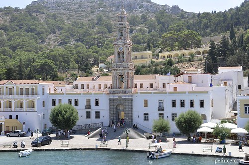
In Greek mythology, Symi is reputed to be the birthplace of the Charites and to take its name from the nymph Syme (in antiquity the island was known as Aigli and Metapontis), though Pliny the Elder and some later writers claimed it came from the word scimmia meaning a monkey.
In Homer's Iliad the island is mentioned as the domain of King Nireus, who fought in the Trojan War on the side of the Greeks. Thucydides writes that during the Peloponnesian War there was a Battle of Syme near the island in January, 411 BC, in which an unspecified number of Spartan ships defeated a squadron of Athenian vessels. Little is known of the island until the 14th century, but archaeological evidence indicates it was continuously inhabited, and ruins of citadels suggest it was an important location.
It was first part of the Roman Empire and then the Byzantine Empire, until its conquest by the Knights of St. John in 1373
Thursday, August 22, 2013


Monday, August 19, 2013

Saturday, August 17, 2013
Fisherman's Bastion, Budapest, Hungary

The Halászbástya or Fisherman's Bastion is a terrace in neo-Gothic and neo-Romanesque style situated on the Buda bank of the Danube, on the Castle hill in Budapest, around Matthias Church. It was designed and built between 1895 and 1902 on the plans of Frigyes Schulek. Between 1947–48, the son of Frigyes Schulek, János Schulek, conducted the other restoration project after its near destruction during World War II.
From the towers and the terrace a panoramic view exists of Danube, Margaret Island, Pest to the east and the Gellért Hill.
Its seven towers represent the seven Magyar tribes that settled in the Carpathian Basin in 896.
The Bastion takes its name from the guild of fishermen that was responsible for defending this stretch of the city walls in the Middle Ages. It is a viewing terrace, with many stairs and walking paths.
A bronze statue of Stephen I of Hungary mounted on a horse, erected in 1906, can be seen between the Bastion and the Matthias Church. The pedestal was made by Alajos Stróbl, based on the plans of Frigyes Schulek, in Neo-Romanesque style, with episodes illustrating the King's life.
It was featured as a Pit Stop on the sixth season of The Amazing Race.
Monday, August 12, 2013
Mount St. Helens from Marquam Hill
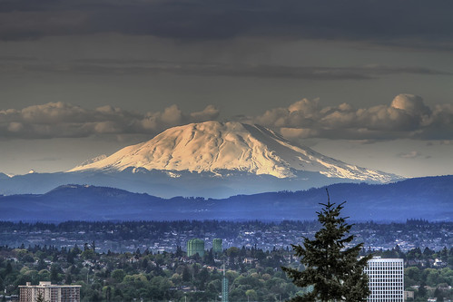
Mt. St. Helens in Washington State. The eruption on May 18, 1980, killed dozens of people and changed the landscape with its 24-megaton blast.
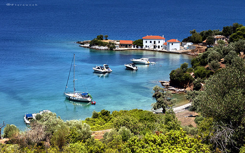
Palamós Beach
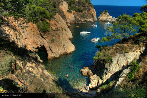
*The Costa Brava is a coastal region of northeastern Catalonia, in the comarques of Alt Empordà, Baix Empordà and La Selva, in the province of Girona. Costa is the Catalan and Spanish word for 'coast', and Brava means 'rugged' or 'wild'. The Costa Brava stretches from Blanes, 60km northeast of Barcelona, to the French border.
In the 1950s the Costa Brava was identified by Spain’s Franco government as being suitable for substantial development as a holiday destination, mainly for package holiday tourists from Northern Europe and especially the United Kingdom and France. The combination of a very good summer climate, nature and excellent beaches was exploited by the construction of large numbers of hotels and apartments in such seaside resorts as Blanes, Tossa de Mar, and Lloret de Mar. Tourism rapidly took over from fishing as the principal business of the area.
Whilst part of the Costa Brava coastline lent itself to tourist developments on a very large scale other parts have retained a more traditional look and have become "hidden gems" for visitors who want a little more than sun, sand and sangria. Small towns like Cadaqués (close to the French border and close to the foothills of the Pyrenees) have attracted artists such as Salvador Dalí (Dalí's Museum at Figueres is one of the most important and visited museums in Catalonia) and Pablo Picasso and are now fashionable resorts. The coast between Roses and Tossa de Mar has many delightful small coastal towns such as Pals, Begur, Tamariu, Llafranc, L'Estartit, Aigua Blava, Fornells, Calella de Palafrugell, Palamós and Sant Feliu de Guixols.
Saturday, August 10, 2013
Diafani, #Karpathos #Dodecanese #Greece
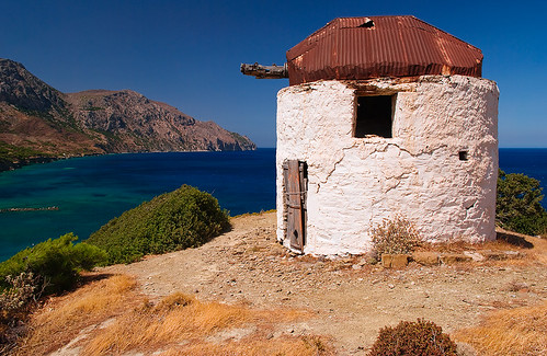
Diafani is a small Greek seaside village situated in a bay on the north-east coast of Karpathos, below the traditional hilltop village of Olymbos. Karpathos is one of the Dodecanese islands in the Aegean sea between Crete and Rhodes.
Diafani is the perfect place for people seeking peace and traditional Greek hospitality.
If you like to walk in herb scented hills and discover small bays for swimming in beautiful clear sea then Diafani is the place for you.
Diafani is for people who want to get away from the stress, pollution and indifference of daily life in the big towns and cities.
Diafani is for walkers, swimmers and dreamers. Diafani is unique.
Agios Theodoros, #Karpathos, #Dodecanese, #Greece
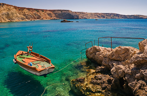
The beaches of Karpathos island can be divided into four large groups: the beaches on the east coast are smaller and gravelly but without wind; the beaches of the southern part of the island, near the airport, area made of fine white sand; the sandy beach on the west coast are the most exposed to the Meltemi and they are only available in low wind conditions; the beaches of the north of the island, accessible only by sea and partly by a jeep.
East Coast: Amoopi, Karpathos Beach, Achata, Kato Latos (reachable only by foot), Apella.
South Coast - Damatria, Diakoftis, Devils Bay, Agriopotamos (nudist beach).
West Coast - Lefkos beach, Mesohori Finiki, Arkasa Leucadius.
North Coast - Diafani, Vananda, Forokli
Tzasteni, mt.Pelion, Magnisia, Greece
This small beach is situated in the soutwest part of Pelion peninsula near the town of Sipiada. Many consider Tzasteni beach as one of the most beautiful beaches of Pelion.
The beach is quite small, covered mainly with pebbles and has cedar trees that provide natural shade for the swimmers. Waters are calm, transparent, clean with shades of blue and green. Like all the beaches of Pelion, Taztani beach also beautifully combines rich and dense greenery of its surrounding with the amazing color of the sea, creating breathtaking landscapes. The beach is entirely unorganized and has no tourist facilities. Consider bringing basic beach necessities with you, water especially, if you decide to spend several hours on this gem of Pelion. The beach is hardly ever crowded and it is ideal place for those who seek where to relax, unwind and enjoy in tranquility and quietness of Pelion's natural beauties. The beach is easily accessible and reachable by private means and accommodation units can be easily found in the nearby settlements.
Pelion peninsula is known for its healthy climate and weather conditions are created by combination of wooded mountains and Aegean Sea. Summers here are pleasant and dry with an average temperature of around 26C° during the summer season. The best time to visit Tzasteni beach is from late May to late September.
Friday, August 9, 2013
Tropea, Calabria, IT...sun salutation...
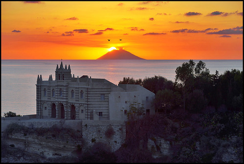
Tropea (ancient Trapeia; Τράπεια in Ancient Greek) is a municipality located within the province of Vibo Valentia, in Calabria (southern Italy).
The town is a famous bathing place, situated on a reef, in the gulf of St. Euphemia connected with the mainland by a narrow strip in the Tyrrhenian Sea, toward the south with respect to Vibo Valentia and northward with respect to Ricadi and Capo Vaticano.
In the Norman cathedral of Tropea there is a picture of Virgin Mary of Romania, of Byzantine origin, dating from around 1330.
The legend says that a boat coming from the east-Byzantine (hence the name Virgin Mary of Romania) was driven by a storm in the port of Tropea. Repaired the damage, the captain tried to leave but the ship still stood in the harbor. On the same night the bishop of the city, Ambrogio Cordova, dreamed of the Virgin Mary asking him to stay in Tropea and becoming its Protectress. The dream repeated for several nights. Eventually the bishop summoned the senior officials and the citizens, and together they went to the port to take the picture of the Virgin Mary. As soon as the painting was brought to shore the ship departed.
The Virgin Mary promised to defend the city from the pestilence, earthquakes and war, and many events that took place since then seem to testify it.
According to tradition, the Virgin Mary appeared in dream several times to the bishop, warning of an earthquake that would devastate Calabria. On the 27 March 1638 the bishop established a penitential procession, involving all the people from Tropea. Thanks to the procession an earthquake which stroke in that same day did not procure any harm to anyone.
The citizens of Tropea were also saved from the 1783 Calabrian earthquakes, much stronger and more tragic than the previous one, that affected the whole of Calabria. This event strengthened the devotion to the Virgin Mary of Romania, and the citizens of Tropea proclaimed her the patron of Tropea.
During World War II Tropea suffered a bombing, but the six bombs which fell on Tropea all fell into a hole and remained unexploded.
White House Ruin Canyon de Chelly
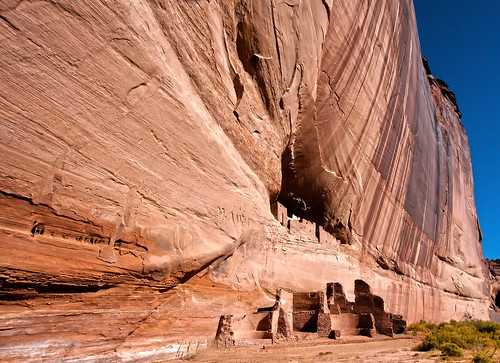
White House ruin in Canyon de Chelly
The canyon walls are comprised of the De Chelly Sandstone of the Cutler Group/Formation. The brown vertical streaks are good examples of "desert varnish" weathering phenomena.
The De Chelly Sandstone member of the Cutler Group are aeolian sand dune deposits from a large dune field (called the DeChelly Erg) that occupied the area of western New Mexico and eastern Arizona around Chinle and the 4 corners area during the Permian
During Paro Tsechu festival, Bhutan.
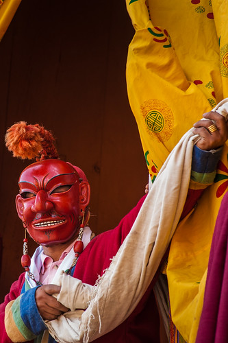
Tsechu (literally "day ten") are annual religious Bhutanese festivals held in each district or dzongkhag of Bhutan on the tenth day of a month of the lunar Tibetan calendar. The month depends on the place, but usually is around the time of October. Tsechus are religious festivals of Drukpa Buddhism. The Thimphu tsechu and tha Paro tsechu are among the biggest of the tsechus in terms of participation and audience. Tsechus are large social gatherings, which perform the function of social bonding among people of remote and spread-out villages. Large markets also congregate at the fair locations, leading to brisk commerce... more: http://en.wikipedia.org/wiki/Tsechu
Wednesday, August 7, 2013

Paris - Fontaine Stravinsky
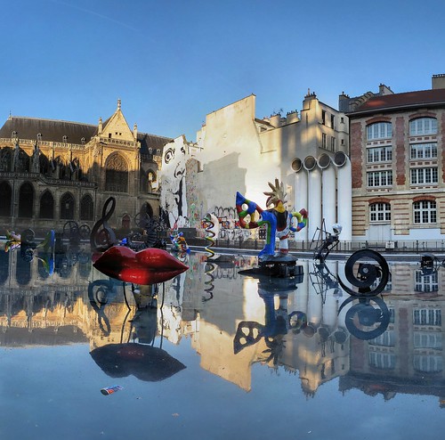
The Stravinsky Fountain (fr: La Fontaine Stravinsky) is a whimsical public fountain ornamented with sixteen works of sculpture, moving and spraying water, representing the works of composer Igor Stravinsky. It was created in 1983 by sculptors Jean Tinguely and Niki de Saint Phalle, and is located on Place Stravinsky, next to the Centre Pompidou, in Paris
