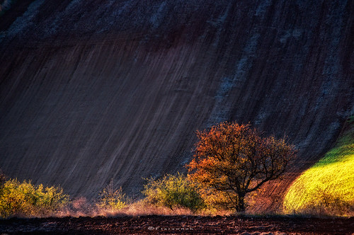
Thursday, December 26, 2013
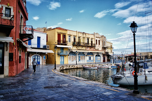
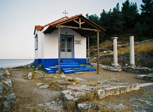
Paros, Greece

Paros (/ˈpɛərɒs/; Greek: Πάρος; Venetian: Paro) is a Greek island in the central Aegean Sea. One of the Cyclades island group, it lies to the west of Naxos, from which it is separated by a channel about 8 kilometres (5 miles) wide. It lies approximately 100 mi (161 kilometres) south-east of Piraeus. The Municipality of Paros includes numerous uninhabited offshore islets totaling 196.308 square kilometres (75.795 sq mi) of land. Its nearest neighbor is the municipality of Antiparos, which lies to its southwest.
Historically, Paros was known for its fine white marble, which gave rise to the term "Parian" to describe marble or china of similar qualities. Today, abandoned marble quarries and mines can be found on the island, but Paros is primarily known as a popular tourist spot.
Monday, December 16, 2013
Guardians of the Past
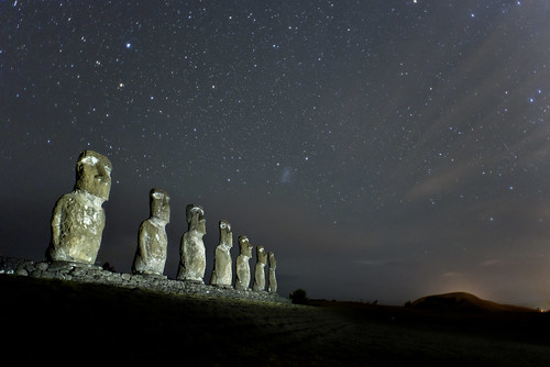
The Moai statues of Easter island’s Ahu Akivi seem to stand guard, possibly protecting the secrets of their mysterious past. Only they, and the vibrant Cosmos above know the true story of Easter Island’s puzzling history.
Norðurljós/Northern lights/Aurora borealis
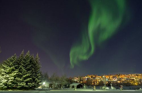
An aurora (plural: aurorae or auroras; from the Latin word aurora, "sunrise" or the Roman goddess of dawn) is a natural light display in the sky particularly in the high latitude (Arctic and Antarctic) regions, caused by the collision of energetic charged particles with atoms in the high altitude atmosphere (thermosphere). The charged particles originate in the magnetosphere and solar wind and, on Earth, are directed by the Earth's magnetic field into the atmosphere. Most aurorae occur in a band known as the auroral zone, which is typically in 3° to 6° latitudinal extent of geographical poles, or equivalently, 10° to 20° latitudinal extent of geomagnetic poles, and at all local times or longitudes. During a geomagnetic storm, the auroral zone expands to lower latitudes.
Aurorae are classified as diffuse and discrete. The diffuse aurora is a featureless glow in the sky that may not be visible to the naked eye, even on a dark night. It defines the extent of the auroral zone. The discrete aurorae are sharply defined features within the diffuse aurora that vary in brightness from just barely visible to the naked eye, to bright enough to read a newspaper by at night. Discrete aurorae are usually seen in only the night sky, because they are not as bright as the sunlit sky. Aurorae occasionally occur poleward of the auroral zone as diffuse patches or arcs (polar cap arcs), which are generally invisible to the naked eye.
In northern latitudes, the effect is known as the aurora borealis (or the northern lights), named after the Roman goddess of dawn, Aurora, and the Greek name for the north wind, Boreas, by Pierre Gassendi in 1621. Auroras seen near the magnetic pole may be high overhead, but from farther away, they illuminate the northern horizon as a greenish glow or sometimes a faint red, as if the Sun were rising from an unusual direction. Discrete aurorae often display magnetic field lines or curtain-like structures, and can change within seconds or glow unchanging for hours, most often in fluorescent green. The aurora borealis most often occurs near the equinoxes. The northern lights have had a number of names throughout history. The Cree call this phenomenon the "Dance of the Spirits". In Medieval Europe, the auroras were commonly believed to be a sign from God.
Its southern counterpart, the aurora australis (or the southern lights), has features that are almost identical to the aurora borealis and changes simultaneously with changes in the northern auroral zone.
It is visible from high southern latitudes in Antarctica, South America, New Zealand, and Australia. Aurorae occur on other planets. Similar to the Earth's aurora, they are visible close to the planet's magnetic poles. Modern style guides recommend that the names of meteorological phenomena, such as aurora borealis, be uncapitalized.
From Wikipedia, the free encyclopedia
Tuesday, December 10, 2013
Mount St. Helens from Marquam Hill
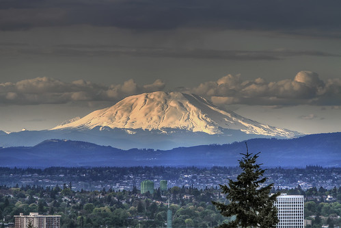
Mt. St. Helens in Washington State. The eruption on May 18, 1980, killed dozens of people and changed the landscape with its 24-megaton blast. And here it is, after its eruption almost** 30 years ago. This is one of the many views you can get from up on Oregon Health & Science University campus on Marquam Hill.
Mother protection against predators
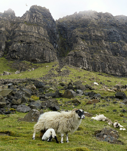
Photo taken at the Trotternish mountains where sheep walk around unfenced but mother ewe must always be aware of the danger from the ground or even from the air.
Moulin Rouge alternative

Moulin Rouge alternative
The house was co-founded in 1889 by Charles Zidler and Joseph Oller, who also owned the Paris Olympia. Close to Montmartre in the Paris district of Pigalle on Boulevard de Clichy in the 18th arrondissement, it is marked by the red windmill on its roof. The closest métro station is Blanche.
Moulin Rouge is best known as the spiritual birthplace of the modern form of the can-can dance. Originally introduced as a seductive dance by the courtesans who operated from the site, the can-can dance revue evolved into a form of entertainment of its own and led to the introduction of cabarets across Europe. Today, Moulin Rouge is a tourist attraction, offering musical dance entertainment for visitors from around the world. The club's decor still contains much of the romance of fin de siècle France.
Wednesday, December 4, 2013
Santa Barbara - Greece - Drama City
According to the legend that surrounds the source of the city, where in 1830 the drama was conquered by the Turks, the chapel of St. Barbara was demolished to build in place of a mosque. The plans of the invaders, but changed ... the day of the Santa Barbara area flooded with water so the mosque was never built. Since then, Saint Barbara became the patron of Drama and just across the lake with the foundations, built the new church dedicated to Saint who saved the church. Thereafter, on December 4 every year our city commemorates the patron saint.
The legend that followed the custom of the boats, the versions of which are two. Under the first, on the eve of Santa Barbara after the procession, people send in sunken chapel a candle for St. on a plank of wood.
The second scenario is based on the Santa Barbara except the artillery was patron and protector of girls who guarded the gossip and helped the "lottery" of their marriage. So all the girls free to December 3, during vespers, and just darkened, lit candles on the east wall of the lake. Some girls put the candles on the planks of wood and with a wish to send the sunken church of St. Barbara. The state board of the lake showed if the prayer could be performed. If the candle extinguished considered a failure but the hope remained, and the next morning all the girls arrived back at the lake to bathe in water that Saint Barbara was to bless the night before.
The years that passed since then and many times he left for good. But the custom of the candles in the lake remained. Only the candles are now traveling on a boat made of children's hands, creating a beautiful and unique atmosphere. That time and has, snow, rain and bitter cold always on December 3 just sourouposei small captains are in their positions and take pride in their ship to be burned or sail away with the other
And if the young people of Drama await the feast of Saint Barbara to throw the boat on the lake, the large waiting to taste the warm and fragrant Barbara that all the housewives are preparing Drama.
The city once the best and celebrate. Once again, all appointments are at noon in procession the image of Saint Barbara and the afternoon on the lake. And then the cold that everyone will feel strongly we expect warm Barbara at home!
Friday, November 29, 2013
Restaurant - Astra Suites, Imerovigli, Santorini, Greece

Restaurant - Astra Suites, Imerovigli, Santorini, Greece, originally uploaded by Astra Suites - Santorini.
it's always summer in Greece
Wednesday, November 20, 2013
Lugano, Canton of Ticino, CH
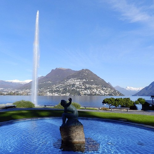
This weeks weather is so bad... I had to throwback to last saturday's visit to Lugano which beside Rio also reminds me of Geneva's beautiful jet d'eau! Wow!, originally uploaded by DaniBachmannCH.
Lugano (dialectal Lügàn) is a city in the south of Switzerland, in the Italian-speaking canton of Ticino, which borders Italy. The population of the city proper was 61,837 as of December 2012, and the population of the urban agglomeration was over 145,000. It is the 9th largest city of Switzerland by population, the largest city in Ticino, and the largest Italian-speaking city outside of Italy.
The city lies on Lake Lugano, surrounded by the mountains of the Lugano Prealps. Its warm summers and the fact that in recent years it has attracted an ever growing number of celebrities, entertainers and successful athletes have given it the nickname of the "Monte Carlo of Switzerland".
Tuesday, November 19, 2013
Feathered Sky
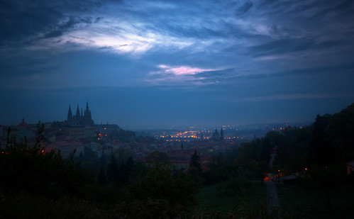
a Prague sunrise shot. This one has a little more colour in the cloudy blue sky though, but not as much colour as you might get in a sunset.
Matterhorn @ Zermatt Swiis Alps
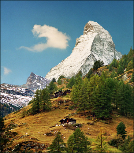
The Matterhorn (German), Cervino (Italian) or Cervin (French), is a mountain in the Pennine Alps. With its 4,478 metres (14,692 ft) high summit, lying on the border between Switzerland and Italy, it is one of the highest peaks in the Alps and its 1,200 metres (3,937 ft) north face is one of the Great north faces of the Alps.
The individual pieces of the chocolate bar Toblerone are claimed by its maker Kraft to be formed in the likeness of the Matterhorn.
Zermatt (French: Praborgne) is a municipality in the district of Visp in the German-speaking section of the canton of Valais in Switzerland.
It is located at the northern base of the Matterhorn in the Pennine Alps, about 10 km from the border with Italy.
Zermatt has a permanent population of around 5,500 people, although the actual population varies considerably through the seasons as tourists come and go. The village is situated at the end of Mattertal, a north-facing valley, at an altitude of 1,620m (5,315ft). The valley is a dead end; although the border with Italy is close, it cannot be crossed by road, as it traverses a glacier at an altitude of over 3,000m. Zermatt is the starting point of the Patrouille des Glaciers and the Haute Route.
en.wikipedia.org/wiki/Matterhorn
en.wikipedia.org/wiki/Zermatt
Greece, Florina, Small Prespa Lake, Island of Agios Achilleios.
Greece, Florina, Small Prespa Lake, Island of Agios Achilleios.
Altitude of 853 meters.Residents are nearly 130 mainly occupied in fishing, farming, agriculture and tourism.
Mystery of the lake @ #Bixad, #Covasna, #Romania
Bixad (Hungarian: Sepsibükszád, Hungarian pronunciation: [ʃɛpʃibyksaːd]) is a commune in Covasna County, Transylvania, Romania. Composed of a single village, Bixad, it was joined to Malnaș in 1968. It once again became an independent commune when it split off in 2004. It lies in the Székely Land, an ethno-cultural region in eastern Transylvania.
Saturday, November 9, 2013
Red roofs, Τallinn, Estonia
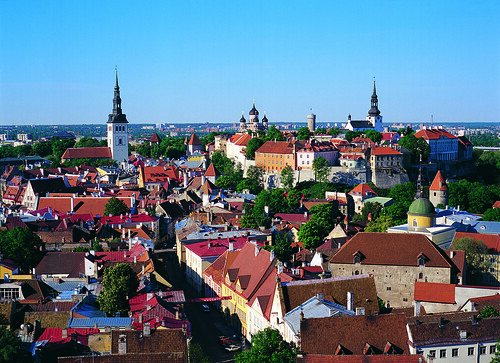
Tallinn is internationally renowned as a tourist destination, receiving more than 1.5 million visitors annually. The number of visitors has been growing steadily over the past decade.
Tallinn Old Town, a UNESCO World Heritage Site, as well as other major attractions, such as the Seaplane Harbour of Estonian Maritime Museum, Tallinn Zoo and the Estonian Open Air Museum contribute to the overall success of the city as a travel destination. While most of the visitors come from Europe, Tallinn has become increasingly more popular in recent years for tourists from Russia and Asia-Pacific region, for which a rapid growth is reported.
Tallinn Passenger Port is one of the busiest cruise destinations on the Baltic Sea, serving more than 520 000 cruise passengers in year 2013. From year 2011 regular cruise turnarounds in cooperation with Tallinn Airport are organised.
Verfen, Austria
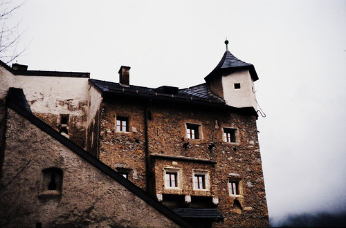
Werfen is located in the northwest of the historic Pongau region, on the southern rim of the Berchtesgaden Alps (east of Mt. Hochkönig) and the Tennengebirge. It is situated in the valley of the Salzach River, about 40 km (25 mi) south of the city of Salzburg. The Salzburg-Tyrol Railway line (Giselabahn) and the Tauern Autobahn run parallel to the river.
Biertan Romania
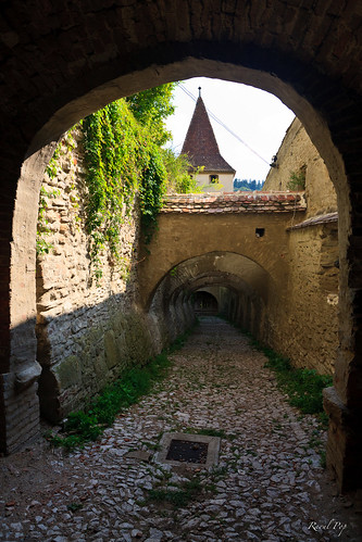
Biertan (German: Birthälm, Romani: Biyertan, Hungarian: Berethalom) is a commune in central Romania, in the north of the Sibiu County, 80 km north of Sibiu (formerly Birthelm in German) and 29 km east of Mediaş. Biertan is one of the most important Saxon villages with fortified churches in Transylvania, having been on the list of UNESCO World Heritage Sites since 1993. It was the see of the Lutheran Evangelical Bishop in Transylvania between 1572 and 1867.
The commune is composed of three villages: Biertan, Copșa Mare (Gross-Kopisch; Nagykapus) and Richiș (Reichesdorf; Riomfalva), each of which has a fortified church.
Monday, October 28, 2013
The Story of Oxi Day
"A journey of a thousand miles must begin with a single step." -- Lao Tzu Copyright © Demetrios the Traveler
Friday, October 25, 2013
Fira
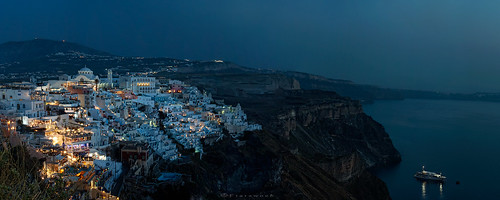
Firá (modern Greek: Φηρά) is the modern capital of the Greek Aegean island, Santorini. A traditional settlement, "Firá" derives its name from an alternative pronunciation of "Thíra", the ancient name of the island itself.
Fira is a city of white-washed houses built on the edge of the 400 metres (1,312 feet) high caldera on the western edge of the semi-circular island of Thera. The two main museums of interest are the Santorini Archeological Museum, 30 metres (98 feet) east of the cable car entrance, and the Museum of Prehistoric Thera at the southeast corner of the White Orthodox Cathedral (with the Greek name meaning Metamorphosis), built on the site of the Ypapanti Church, destroyed in the 1956 earthquake.
Access to Fira is mainly by roads on its eastern side, climbing from its port via the Z-shaped footpath on foot or on donkeys, or by riding the steep cable car from its lower terminal by the port. The central square of Fira is called Plateia Theotokopoulou, with a bus and taxi station, banks and pharmacies.
The narrow paths, lined with all kinds of souvenir shops, jewelry shops, and restaurants linking the upper cable car terminal and the central square, are packed with tourists during the summer seasons.
From Fira there is a panoramic view of the 18 kilometres (11 miles) long caldera from southern Cape Akrotiri to northern Cape Ag. Nikolaos, plus the volcanic island Nea Kameni at the center with Thirassia Island in the Aegean. Large cruise ships anchor in the small harbor between Nea Kameni and Fir
Monday, October 21, 2013
Coastline near #Kalathas, #Crete, #Greece
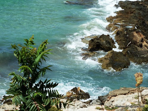
The seaside village of Kalathas is located 12km northeast of Chania, in the heart of a large natural bay on the Akrotiri peninsula, which is open to the north winds. Kalathas is a relatively modern village, which has been inhabited by residents of Chania who wanted to live away from the city center.
The beach in front of the village is beautiful, with fine sand and shallow crystal clear water. Opposite Kalathas, there is a small island which you can easily reach by swimming. Next to the beach there are several palm trees that give an exotic tone to the landscape. Moreover, the beach is very well organized with umbrellas, water sports, restaurants, hotels, mini markets, etc.
West of the main bay, beyond the rocky end, there is a secluded sandy bay. This is not organized and is ideal for those who do not like crowded places.
#Belton, #North Lincolnshire, #UK

Belton is a village and civil parish in the Isle of Axholme area of North Lincolnshire, England, that lies on the A161 road six miles east from Scunthorpe. To the north of Belton is the town of Crowle; to the south, the village of Epworth.
Belton parish boundaries include the hamlets of Beltoft, Sandtoft, Churchtown, Bracon, Carrhouse, Mosswood, Grey Green and Westgate. Within the parish is the now broken up country house estate of Temple Belwood. Hirst Priory at Sandtoft still stands.
According to the 1991 census, Belton had a population of 2,549.
caves, #Paxos, #Ionian sea, #Greece
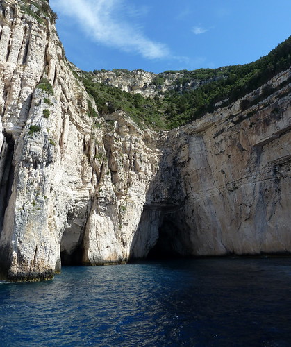
The island is approximately eight miles (13 km) in length and tipped up towards the west. The west coast is dominated by steep white, chalky cliffs that are greatly eroded at sea level, and harbour many 'blue caves', which can be explored on launches departing from Gaios. Much of the attractive landscape is still covered in olive groves. These stretch from Lakka, the harbour community in the north, through Magazia to Gaios, the capital. Olive oil making, soap manufacture and fishing were supplanted by tourism as the main industry in the mid sixties, resulting in a construction boom, which has greatly altered the coastline around Gaios, the capital of the Paxiot demos (community). There are ferry and jetfoil connections daily with Kerkyra (Corfu) and with the mainland at Parga.
Sunday, October 20, 2013
Sunday's rest
Τα πλοία πεθαίνουν στα λιμάνια
και μάτια δακρύζουν στα μουράγια
Οι αγάπες μου ξέμπαρκοι ναύτες,
στα όνειρα τους λιποτάκτες.
Friday, October 18, 2013
Castle Stalker, Appin, Argyll Scotland
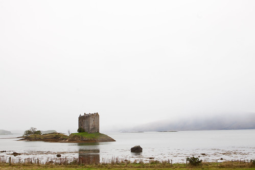
Castle Stalker – in the Gaelic, Stalcaire, meaning Hunter or Falconer – is believed originally to have been the site of a Fortalice (a small fortified building) belonging to the MacDougalls when they were Lords of Lorn, and built around 1320. The MacDougalls lost their title after their defeat by King Bruce at Brander Pass in 1308 but regained it for a period after 1328. In about 1388 the Lordship of Lorn passed to the Stewarts, the lands including Castle Stalker.
It is believed that Castle Stalker, much in its present form, was built by the then Lord of Lorn, Sir John Stewart, who had an illegitimate son in 1446, and it is reasonable to suppose that he built and occupied the Castle about that time. In 1463 Sir John Stewart was keen to legitimise his son by getting married to his Mother, a MacLaren, at Dunstaffnage when he was murdered outside the church by Alan MacCoul, a renegade MacDougall, although he survived long enough to complete the marriage and legitimise his son, Dugald, who became the First Chief of Appin. The Stewarts had their revenge on MacCoul at the Battle of Stalc in 1468 opposite the Castle when the Stewarts and MacLaren together defeated the MacDougalls, and Alan MacCoul was killed by Dugald himself. The site of this Battle is marked by a memorial stone in the Churchyard in Portnacroish.
In 1497 the Stewarts and MacLarens carried out a combined raid against MacDonald of Keppoch as a reprisal for cattle reiving, but Dugald Stewart was killed and succeeded as Chief of Appin by his son Duncan. King James IV of Scotland, born in 1473, was a cousin of the Stewarts of Appin and when he came of age made frequent hunting journeys to the Highlands. It is understood that he stayed quite often at Castle Stalker, using it as a base for hunting and hawking for which he had a passion. It is thought that further improvements were made to the Castle at this time including the possible addition of what is now the top floor and roof, and that the Coat of Arms over the front door may be the Royal Arms of that time.
Duncan Stewart was murdered by the McLeans at Duart Castle in 1512 and succeeded by his younger brother Alan Stewart as the third Chief. In 1513 the Stewarts of Appin supported King James IV at the Battle of Flodden. The Stewart Chief and is five sons were all present at the Battle but all managed to survive what was otherwise a massive defeat in which the King was killed.
In 1520 Sir Alexander Stewart of Invernahyle was fishing off the small island next to Castle Stalker when he was surprised and murdered by a party of Campbells. Tradition has it that the nurse of his baby son, Donald Stewart, hid the baby in the Castle and when the Campbells left the nurse returned, found the baby still alive and took refuge in Morven.
Young Donald became renowned for his strength and was known as “Donald of the Hammers” – in the Gaelic “Donald nan Ord” – as he could wield a blacksmith’s hammer in each hand with ease. In 1544 he raised the Stewarts of Appin and went to Dunstaffnage where they killed nine Campbells in revenge for the murder of his Father. Donald nan Ord also led the Stewarts at the Battle of Pinkie on the 10th September 1547. He died in 1607 and is buried on Lismore where his faithful henchman, a Carmichael, also lies buried.
In around 1620 the Castle passed into the hands of the Campbells of Airds as a result of a drunken wager by the 7th Stewart Chief, Duncan, in exchange for an eight-oared wherry.
The Stewarts of Appin, under Stewart if Ardsheal, regained the Castle in 1689 when they came out with King James VII (otherwise James II) against King William but after defeat at the battle of Dunkeld the Castle was again forfeited to the Campbells. The Stewarts under Ardsheal refused to hand it over when it was then besieged by the Campbells for several months until Ardsheal was granted an honourable surrender in 1690.
At the time of the 1745 Rising Castle Stalker was held by the Campbells with a Garrison of about 59 Government troops. Although the Stewarts of Appin were solidly behind Prince Charles, and raised a regiment of 300, the Castle was too strong for them to take and their 2lb cannon-balls merely bounced off the walls. The Castle formed an important link during the rising with ships calling frequently with men and supplies as they sailed between Inverary in the South and Fort William in the North. After the Battle of Culloden in 1746 the Castle was used by the Government forces as a local centre where the Clansmen had to surrender their arms. Six prisoners are recorded as being held in the Prisoners’ Hole for about a fortnight before being taken to Edinburgh for trial.
The last Campbell was born in the Castle in 1775 and Campbells continued to reside in it until about 1800 when they built a new house on the mainland at Airds, which still exists today, and the Castle remained merely as a storehouse. In about 1840 the roof either fell in or was perhaps removed to avoid roof-tax and the Castle was abandoned.
In 1908 the Castle was regained from the Campbells by Charles Stewart of Achara who purchased it and carried out some basic preservation work to stem its decay.
In 1947 his successor, Duncan Stewart, who was Governor of Sarawak, was murdered by a Dyak and the Castle devolved on his widow. In 1965 Lt. Col. D. R. Stewart Allward negotiated terms for the purchase of the Castle and spent the next ten years rebuilding and restoring it as it is today. It is now fully habitable. Contractors and builders in the normal sense were not employed in the restoration which was carried out by Lt. Col. Stewart Allward personally with the help of his wife, family and many friends who were willing to spend holidays and long weekends helping with the task.
Lt. Col. Stewart Allward died suddenly whilst out walking on the 5th February 1991. His wife Marion, always of great support to him, died on the 7th July 2005.
huangshan hotel,china
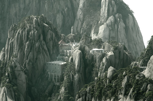
Having at least 140 sections open to visitors, Huangshan is a major tourist destination in China.
In 2007, for instance, over 15 million tourists visited the mountain.
The foot of the mountains is linked by rail and by air to Shanghai, and is also accessible from cities such as Hangzhou and Wuhu.
As of 1990, there were over 50 kilometers of footpaths providing access to scenic areas for visitors and staffers of the facilities.
Today there are also cable cars that tourists can use to ride directly from the base to one of the summits.
Throughout the area there are hotels and guest houses that accommodate overnight visitors, many of whom hike up the mountains, spend the night at one of the peaks to view the sunrise, and then descend by a different route the next day. The area is classified as a AAAAA scenic area by the China National Tourism Administration.
The hotels, restaurants, and other facilities at the top of the mountain are serviced and kept stocked by porters who carry resources up the mountain on foot, hanging their cargo from long poles balanced over their shoulders or backs.
Wednesday, October 9, 2013
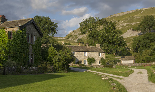
Banks of the Wharfe, Yorkshire, UK

The River Wharfe is a river in Yorkshire, England. For much of its length it is the county boundary between West Yorkshire and North Yorkshire. The name Wharfe is Celtic and means "twisting, winding".
The valley of the River Wharfe is known as Wharfedale. The river source is at Beckermonds, Langstrothdale in the Yorkshire Dales National Park and flows through Kettlewell, Grassington, Bolton Abbey, Addingham, Ilkley, Burley-in-Wharfedale, Otley, Wetherby and Tadcaster. It then flows into the River Ouse near Cawood. The section of the river from its source to around Addingham is known as Upper Wharfedale and has a very different character to the river downstream.
The river is approximately 97 km long before it joins the River Ouse. It is a public navigation from the weir at Tadcaster to its junction with the River Ouse near Cawood and tidal from Ulleskelf.

Saturday, October 5, 2013
Pedoulas Village

Pedoulas (Greek: Πεδουλάς) is a village in the Nicosia District of Cyprus, located 4 km south of Moutoullas. The town has a famous St. Michael church.
Place Sablon - Bruxelles - Belgium
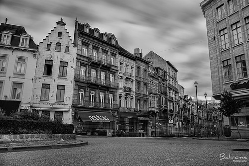
an important square on a hill by the same name, in the old area of Brussels
Tuesday, October 1, 2013
Friday, September 27, 2013
Milky Way

When observing the night sky, the term "Milky Way" is limited to the hazy band of white light some 30 degrees wide arcing across the sky (although all of the individual stars that can be seen with the naked eye are part of the Milky Way Galaxy). The light in this band originates from un-resolved stars and other material that lie within the Galactic plane. Dark regions within the band, such as the Great Rift and the Coalsack, correspond to areas where light from distant stars is blocked by interstellar dust.
The Milky Way has a relatively low surface brightness. Its visibility can be greatly reduced by background light such as light pollution or stray light from the moon. It is readily visible when the limiting magnitude is +5.1 or better, while showing a great deal of detail at +6.1. This makes the Milky Way difficult to see from any brightly lit urban or suburban location but very prominent when viewed from a rural area when the moon is below the horizon.[nb 2]
The Milky Way passes through parts of roughly 30 constellations. The center of the Galaxy lies in the direction of the constellation Sagittarius; it is here that the Milky Way is brightest. From Sagittarius, the hazy band of white light appears to pass westward to the Galactic anticenter in Auriga. The band then continues westward the rest of the way around the sky back to Sagittarius. The band divides the night sky into two roughly equal hemispheres.
The Galactic plane is inclined by about 60 degrees to the ecliptic (the plane of the Earth's orbit). Relative to the celestial equator, it passes as far north as the constellation of Cassiopeia and as far south as the constellation of Crux, indicating the high inclination of Earth's equatorial plane and the plane of the ecliptic relative to the Galactic plane. The north Galactic pole is situated at right ascension 12h 49m, declination +27.4° (B1950) near beta Comae Berenices, and the south Galactic pole is near alpha Sculptoris. Because of this high inclination, depending on the time of night and the year, the arc of Milky Way can appear relatively low or relatively high in the sky. For observers from about 65 degrees north to 65 degrees south on the Earth's surface the Milky Way passes directly overhead twice a day.
From Wikipedia, the free encyclopedia
Wednesday, August 28, 2013
Conistone, Yorkshire, England.
A sleepy little village clustered around a green with a Maypole, a little corner of paradise in the dales.
Conistone is a small village (population 117 in the 2001 census) in North Yorkshire, England. It lies 3 miles north of Grassington, beside the River Wharfe, in Upper Wharfedale.
The village is set in characteristic limestone scenery, including Mossdale Caverns, the dry gorge of Conistone Dib and the limestone outcrop of Conistone Pie. Above the Dib the Dales Way path connects Kettlewell, to its north, and Grassington, to its south, providing distant views over Wharfedale. From the B6160 road, the Wharfe is crossed at Conistone by a stone-arch bridge, which is within easy walking distance of Kilnsey, with its Crag.
The parish church, St Mary's Church, dates from the 11th or 12th century, and is a Grade II listed building.
Conistone was historically in the large ancient parish of Burnsall, in Staincliffe Wapentake in the West Riding of Yorkshire. It became part of the civil parish of Conistone with Kilnsey in 1866,[2] and was transferred to North Yorkshire in 1974.
Blenheim Palace

Home to the 11th Duke and Duchess of Marlborough, Blenheim Palace is the birthplace of Sir Winston Churchill and a World Heritage Site.
Blenheim Palace was a gift from Queen Anne and a grateful nation to John Churchill, 1st Duke of Marlborough following his famous victory at the Battle of Blenheim in 1704. Visit the gilded State Rooms, which house one of the finest collections in Europe, and the fascinating visitor experience, ‘Blenheim Palace: The Untold Story’. The Churchill Exhibition includes the room where Sir Winston Churchill was born 1874.
Situated in Woodstock, just 8 miles from Oxford, Blenheim Palace is surrounded by over 2,000 acres of 'Capability' Brown landscaped parkland, the great lake, and beautiful formal gardens, offering an unforgettable day out for all.
Symi
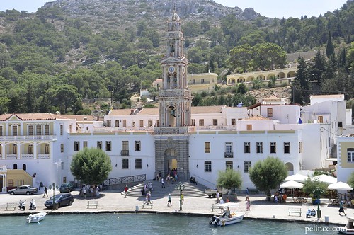
In Greek mythology, Symi is reputed to be the birthplace of the Charites and to take its name from the nymph Syme (in antiquity the island was known as Aigli and Metapontis), though Pliny the Elder and some later writers claimed it came from the word scimmia meaning a monkey.
In Homer's Iliad the island is mentioned as the domain of King Nireus, who fought in the Trojan War on the side of the Greeks. Thucydides writes that during the Peloponnesian War there was a Battle of Syme near the island in January, 411 BC, in which an unspecified number of Spartan ships defeated a squadron of Athenian vessels. Little is known of the island until the 14th century, but archaeological evidence indicates it was continuously inhabited, and ruins of citadels suggest it was an important location.
It was first part of the Roman Empire and then the Byzantine Empire, until its conquest by the Knights of St. John in 1373
Thursday, August 22, 2013


