Showing posts with label UK. Show all posts

Tuesday, January 17, 2012

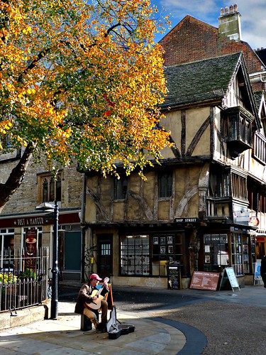
Oxford, England, UK

Oxford is the oldest university city in the United Kingdom, situated some 50 miles (80 km) to the west of the capital London in its own county of Oxfordshire, and located on the rivers Thames (the section of the Thames in Oxford is known as "The Isis") and Cherwell. Together with Cambridge (the second oldest university city and Oxford's great rival), Oxford has long represented the British academic establishment and élite ("Oxbridge"), a haven of tradition and endeavour. Oxford's famous "Dreaming Spires" refer to the medieval churches and colleges that dominate the bustling modern town in all their Gothic splendour. Picturesque architecture and a vibrant modern life (driven by students, light industry and technology) set in the rolling countryside of Oxfordshire make this a great destination.
via Wikipedia
Sunday, November 20, 2011

Greenland Dock , London UK

photo via Roman Gerodimos

Greenland Dock is the oldest of London's riverside wet docks, located in Rotherhithe in the area of the city now known as Docklands. It used to be part of the Surrey Commercial Docks, most of which have by now been filled in. Greenland Dock is now used purely for recreational purposes; it is one of only two functioning enclosed docks on the south bank of the River Thames.


The dock was originally laid out between 1695-99 on land owned by the aristocratic Russell family of the 1st Duke of Bedford. The Russells had been given a portion of land in lower Rotherhithe by a wealthy Streatham landowner, John Howland, as part of a wedding dowry for his daughter Elizabeth, granddaughter of Sir Josiah Child - the dictatorial chairman of the East India Company, who married Wrothesley Russell, the Marquis of Tavistock. They immediately set about "improving" the rural property, obtaining parliamentary permission in 1695 to construct a rectangular dock with an area of about 10 acres (4.0 ha), capable of accommodating around 120 ships. It was named Howland Great Wet Dock in honour of John Howland. Designed by local shipwright, John Wells, the dock was intended to refit East India ships.


more info via Wikipedia


"A journey of a thousand miles must begin with a single step." -- Lao Tzu Copyright © Demetrios the Traveler

Saturday, September 24, 2011

St. Kilda, Scotland, UK


St Kilda (Scottish Gaelic: Hiort) is an isolated archipelago 64 kilometres (40 mi) west-northwest of North Uist in the North Atlantic Ocean. It contains the westernmost islands of the Outer Hebrides of Scotland. The largest island is Hirta, whose sea cliffs are the highest in the United Kingdom. The islands are administratively a part of the Comhairle nan Eilean Siar local authority area.
St Kilda was permanently inhabited for at least two millennia, with its population probably never exceeding 180 (and certainly no more than 100 after 1851). The entire population was evacuated from Hirta (the only inhabited island) in 1930. Currently, the only year-round residents are defence personnel although a variety of conservation workers, volunteers and scientists spend time there in the summer months.
The origin of the name St Kilda is a matter of conjecture. The islands' human heritage includes numerous unique architectural features from the historic and prehistoric periods, although the earliest written records of island life date from the Late Middle Ages. The medieval village on Hirta was rebuilt in the 19th century, but the influences of religious zeal, illnesses brought by increased external contacts through tourism, and the First World War all contributed to the island's evacuation in 1930. The story of St Kilda has attracted artistic interpretations, including an opera.
The entire archipelago is owned by the National Trust for Scotland. It became one of Scotland's five World Heritage Sites in 1986 and is one of the few in the world to hold joint status for its natural and cultural qualities. Two different early sheep types have survived on these remote islands, the Soay, a Neolithic type, and the Boreray, an Iron Age type. The islands are a breeding ground for many important seabird species including Northern Gannets, Atlantic Puffins, and Northern Fulmars. The St Kilda Wren and St Kilda Field Mouse are endemic subspecies. Parties of volunteers work on the islands in the summer to restore the many ruined buildings that the native St Kildans left behind. They share the island with a small military base established in 1957.

Saturday, March 5, 2011

The Old Pier, North Queensferry, Fife Scotland, UK


The Old Pier, originally uploaded by Duncan_Smith.

North Queensferry is a village in Fife, Scotland, on the Firth of Forth, between the Forth Bridge and the Forth Road Bridge, and 10 miles (16.1 km) from Edinburgh. According to the 2008 population estimate, the village has a population of 1,150.

Thursday, November 18, 2010

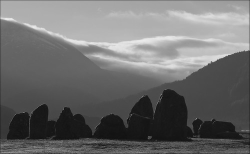
Castlerigg, Keswick, England, UK


Castlerigg dawn 4, originally uploaded by bingleyman2.
It was such a great mood that I think it justifies multiple images. A 5000 year old sight.

Castlerigg Stone Circle (alt. Keswick CarlesCarlesCarsles or Castle-rig) near Keswick in England is one of the most visually impressive prehistoric monuments in Britain and is the most visited stone circle in Cumbria. Every year, thousands of people make the short journey from Keswick to the plateau of Castlerigg Fell and to Chestnut Hill, on which the monument stands. This plateau forms the raised centre of a natural amphitheatre created by the surrounding fells and from within the circle it is possible to see some of the highest peaks in Cumbria:HelvellynSkiddawGrasmoor and Blencathra.


From Wikipedia, the free encyclopedia

Sunday, September 19, 2010

South Cornwall: the perfect break UK

A trip to the Roseland Peninsula in many ways represents a journey back to what Cornwall was like before camper van-toting surfers, inebriated teenagers and DFL (Down From London) families invaded the county. From bustling St Mawes to sleepy Portloe, this corner of south Cornwall is characterised by castle ruins, lush gardens, fishing villages, thatched cottages, coastal walks and wild beaches, and favoured by one of the mildest climates in Britain.


London in a new light

Taxis on Bishop's Bridge Road, queuing for Paddington Station


Friday, August 6, 2010

Crackpot Hall, Swaledale, North Yorkshire UK


Crackpot Hall, Swaledale., originally uploaded by bingleyman2.

The ruins of Crackpot Hall lie about a mile east of Keld on the northern slope of the dale at grid reference NY906008. There may have been a building on this site since the 1500s when ahunting lodge was maintained for Thomas, the first Baron Wharton, who visited the Dale occasionally to shoot the red deer. Survey work by the Yorkshire Dales National Park Authority has shown that the building has changed many times over the years. At one time it even had a heather or "ling" thatched roof.
The current ruin is of a farmhouse dating from the mid 1700s. It was an impressive two story building with a slate roof and matching "shippons" or cow sheds at each end for animals. The building may also have been used as mine offices, as intensive lead mining was carried out in the area, and there were violent disputes over mine boundaries in the 18th century.
The current building was abandoned in the 1950s because of subsidence. Crackpot Hall has been saved from further decay by Gunnerside Estate with the aid of grants from the Millennium Commission and European Union through the Yorkshire Dales Millennium Trust.In the 1930s Ella Pontefract and Marie Hartley wrote of a wild 4-year-old child living here by the name of Alice.
The name Crackpot is said to be Viking for "a deep hole or chasm that is a haunt of crows"..


Keld is a hamlet in the English county of North Yorkshire. It is situated on Birkdale, in the Yorkshire Dales. The name derives from the Viking word Kelda meaning a spring, and the village was once called Appletre Kelde - the spring near the apple trees.

Keld is the crossing point of the Coast to Coast Walk and the Pennine Way long distance footpaths at the head of Swaledale. Unfortunately it does not contain a shop. There was a Youth Hostel but this closed in October 2006; the building has since reopened as Keld Lodge, a hotel with bar and restaurant.

There is a series of four waterfalls close to Keld at a limestone gorge on the River Swale. These are Kisdon Force, East Gill Force, Catrake Force and Wain Wath Force.

Monday, June 14, 2010

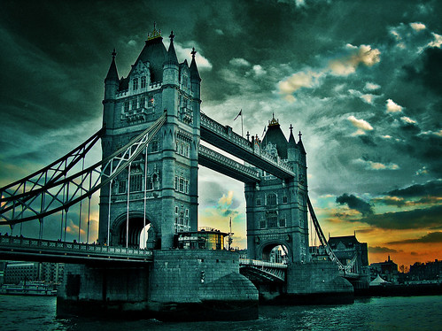
Tower bridge, London UK


Tower bridge, originally uploaded by brunoat.


movable bridge of the double-leaf bascule (drawbridge) type that spans the River Thames between the Greater London boroughs of Tower Hamlets and Southwark. It is a distinct landmark that aesthetically complements the Tower of London, which it adjoins.
The bridge was completed in 1894 and provides an opening 250 feet (76 metres) wide. Its twin towers rise 200 feet (61 metres) above the Thames.
Between the towers stretch a pair of glass-covered walkways that are popular among tourists. The walkways were originally designed to allow pedestrians to cross even while the bridge was raised, but they became hangouts for prostitutes and thieves and so were closed from 1909 to 1982.
The Tower Bridge was operated by hydraulic pumps driven by steam until 1976, when electric motors were put into operation; the steam power system is still kept (in good repair) as a tourist display. Because of the reduction in shipping at the London Docklands, however, the leaves are now seldom raised.
source: Wikipedia

Photo Soundtrack: "Final Battle", from Van Helsing. (Composed by Alan Silvestri).

30 secs audio clip (real audio) here.
Complete audio clip (mp3 24 kbps) here.

See more info about Photo Soundtrack here.


"A journey of a thousand miles must begin with a single step." -- Lao Tzu
Copyright © Demetrios the Traveler


Digg!

Lamberts Castle, Dorset, UK


A walk around Lamberts Castle offers stunning views of the Marshwood Vale with its clay valleys and rolling greens and hills. On a clear day you can see Chesil beach and Portland to the east and out toward the sea at Charmouth to the south.

Lambert's Castle is an Iron Age hill fort in Dorset, England, United Kingdom.
The fort rises to a height of 256 m on a broad northerly spur, with steep natural slopes on three sides, and linear ramparts across the flat southern approaches.
The site is owned by the National Trust. The is a car park accessible down a track off the B3165 east of Axminster. Coney's Castle is about 1.5 km to the south, and Pilsdon Pen about 5 km to the north-east.
It is also a Site of Special Scientific Interest on account of its geology, archaeology and ecology. It was notified as an SSSI in 1981.

Main hillfort with repairs to the ramparts Photo: NATIONAL TRUST

more @: Lambert's castle
and @: Lamberts Castle, Dorset: Walk of the week - Telegraph

"A journey of a thousand miles must begin with a single step." -- Lao Tzu Copyright © Demetrios the Traveler

Saturday, June 5, 2010

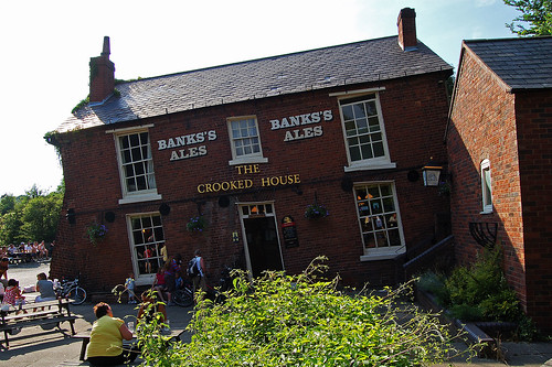
The Crooked House, Dudley UK


This is the Crooked House or the Glynne Arms at Himley. In the past it has suffered badly from mining subsidence. It lies on what was the divide between Sir Stephen Glynne's land and that of the Earl of Dudley.

Glynne removed too much of the coal that lies underneath, and the building began to sink. However, after been propped up, the interior was extensively altered to create an optical illusion. Here is a place where golf balls roll uphill!
"A journey of a thousand miles must begin with a single step." -- Lao Tzu Copyright © Demetrios the Traveler

Sunday, May 30, 2010

Bay of Laig, Isle of Eigg, Scotland


Eigg Meets Rum, originally uploaded by antsplan.
Something that strikes you when you are on Eigg is the large number of non-Scottish accents, ok I'll say it, there are a lot of English accents. Indeed Karen the owner of our bunkhouse was certainly not a native of the island.

I later discovered that actually there were only two indigenous families left on Eigg. In some ways this makes me kinda sad. Indigenous families believed there was nothing there for their kids, they were encouraged to leave to make a better life. How things have changed, how many of us now see island life as an idyl and if we had the cohones would love to live that existance?

I think there is a deeper question though. Why aren't Scottish people embracing their own country, more welcoming to outsiders and more capable of providing the hospitality that tourism demands ? It seems to me that the settlers throughout the H & I and very often these are English families are far more geared up to doing this successfully.

After initially being slightly perturbed at the Scots/English mix living and owning Eigg, I soon realised something. People on Eigg, NEVER walk past you, everyone waves as they go past, everyone has a decent word to say to visitors, they genuinely seem to want to share their little spot of paradise with you or if thats not the case, they at least appreciate your tourism dollars, either way your made to feel welcomed. This sadly is not always the case in many of the more Scottish tourist spots in the highlands/Islands. I think you can often feel like your not wanted, almost a hinderance. I've certainly experienced this on Skye and I love Skye BTW.

What makes Eigg that wee bit extra special is that the community that now own it, are in my opinion mindful, that they too were once outsiders.

more @ http://wikitravel.org/en/Eigg

"A journey of a thousand miles must begin with a single step." -- Lao Tzu Copyright © Demetrios the Traveler

Sunday, May 23, 2010

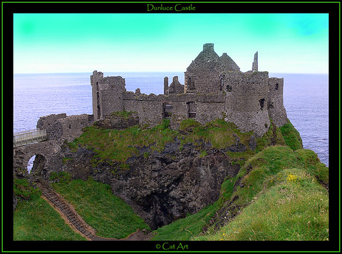
Dunluce Castle, Antrim Coast, Northern Ireland.


Dunluce Castle, originally uploaded by Cat-Art.

The limestone cliffs of the White Rocks ends abruptly against a dark basalt outcrop which is majestically crowned by Dunluce Castle and joined to the mainland by an arched walkway, underneath lies the ' Mermaid's Cave'. It is believed that the castle was built or (possibly) rebuilt by Richard de Burgh or one of his chief followers during the Anglo Norman period in Ireland. The site certainly was occupied as a fort before this time, a souterrain exists on the outcrop under one of the towers. The castle which has seen many additions to its original structure over the centuries gradually fell into disuse from the late 1600s' when the last occupier, Randall MacDonnell, the second Earl of Antrim moved to Ballymagarry House. In the mid 1700s the seat of the Earl's of Antrim moved to the present location of Glenarn Castle. A thriving merchant village that once surrounded the castle was destroyed by fire during 1641 when the castle was besieged by an Irish army, the outlines of some of the old walls can still be seen in the land to the west of the castle. Close by is the ancient church ruins of St. Cuthbert's named after a Northumbrian monk and the (possible) burial site of sailors and noblemen from the Spanish Armada. The most colourful occupier of Dunluce Castle was Sorley Boy MacDonnell, a Scottish chieftain whose clan established their dominance along the north coast in the mid 1500s, he had many differences of opinion with Queen Elizabeth who sent Sir John Perrottt here in 1584 to bring him to task but Sorley evaded arrest. Dunluce Castle was fought over many times in its past and it is wrapped in myths and legends. On a clear day you can look over an expanse of ocean from here to Donegal and round to Islay, a view which has remained unchanged for centuries.

Monday, May 10, 2010

red telephone box, London - UK

The red telephone box, a public telephone kiosk designed by Sir Giles Gilbert Scott, is a familiar sight on the streets of the United Kingdom, Malta, Bermuda and Gibraltar, and despite a reduction in their numbers in recent years, red boxes can still be seen in many places and current or ex-British Colonies around the world. The colour red was chosen to make them easy to spot.


"A journey of a thousand miles must begin with a single step." -- Lao Tzu Copyright © Demetrios the Traveler

Saturday, April 17, 2010

St Agnes Clift Tops, Cornwal, UK


St Agnes Clift Tops, originally uploaded by Bob.Bee.
St Agnes (Cornish Breanek) is a village and a parish on the north coast of Cornwall, England. It is in the Cornwall and West Devon Mining Landscape World Heritage Site, and lies halfway between the artists' colony of St Ives and the surfers' paradise at Newquay. It is one of the twelve sections of the Cornwall Area of Outstanding Natural Beauty (AONB).
St Agnes grew up as a fishing and farming community which, from Roman times (perhaps earlier) until the early part of the 20th century, relied heavily on tin mining as a source of income.
With the demise of mining in Cornwall, St Agnes has become a popular tourist destination, offering excellent beaches at Trevaunance Cove, Chapel Porth National Trust beach, and nearby Perranporth and Porthtowan; walking (St Agnes Beacon and many cliff, coastal and country walks); painting (beautiful scenery), industrial archeology, stone-age remains and geology.

"A journey of a thousand miles must begin with a single step." -- Lao Tzu
Copyright © Demetrios the Traveler


Wednesday, March 31, 2010

Snowy Manchester, UK

Manchester is a city and metropolitan borough of Greater Manchester, England. In 2008, the population of the city was estimated to be 464,200, making it the seventh-most populous local authority district in England. Manchester lies within one of the UK's largest metropolitan areas; the metropolitan county of Greater Manchester had an estimated population of 2,562,200, the Greater Manchester Urban Area a population of 2,240,230, and the Larger Urban Zone around Manchester, the second-most-populous in the UK, had an estimated population in the 2004 Urban Audit of 2,539,100. The demonym of Manchester is Mancunian.
Manchester is situated in the south-central part of North West England, fringed by the Cheshire Plain to the south and the Pennines to the north and east. The recorded history of Manchester began with the civilian vicus associated with the Roman fort of Mamucium, which was established c. AD 79 on a sandstone bluff near the confluence of the rivers Medlock and Irwell. Historically, most of the city was a part of Lancashire, although areas south of the River Mersey were in Cheshire. Throughout the Middle Ages Manchester remained a manorial township, but began expanding "at an astonishing rate" around the turn of the 19th century as part of a process of unplanned urbanisation brought on by a boom in textile manufacture during the Industrial Revolution. The urbanisation of Manchester largely coincided with the Industrial Revolution and the Victorian era, resulting in it becoming the world's first industrialised city. As the result of an early-19th century factory building boom, Manchester was transformed from a township into a major mill town, borough and was later granted honorific city status in 1853.
Forming part of the English Core Cities Group, Manchester today is a centre of the arts, the media, higher education and commerce, factors all contributing to Manchester polling as the second city of the United Kingdom in 2002. In a poll of British business leaders published in 2006, Manchester was regarded as the best place in the UK to locate a business. A report commissioned by Manchester Partnership, published in 2007, showed Manchester to be the "fastest-growing city" economically. In the GaWC global city list, Manchester is ranked as a Gamma city. It is the third-most visited city in the United Kingdom by foreign visitors and the most visited in England outside London. Manchester was the host of the 2002 Commonwealth Games, and among its other sporting connections are its two Premier League football teams, Manchester United and Manchester City.

"A journey of a thousand miles must begin with a single step." -- Lao Tzu
Copyright © Demetrios the Traveler


Thursday, March 25, 2010

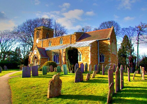
Knossington St Peter's church, Leicestershire, UK


Knossington is a thriving community, set in the rolling Leicestershire countryside. The village is located 8 miles from Melton Mowbray and 4 miles from Oakham. The Fox & Hounds provides a good centre for social life in Knossington, as does the Village Hall and the CofE Church. All 3 attractions are conveniently located towards the centre of the village.

Although the residents of Knossington are increasingly travelling away from the village to work on a daily basis, farming remains a primary industry within the village.

Knossington Grange is a major employer in the village and the Special Needs school is considered to be a centre of excellence for pupils (boys only to the age of 16 years) who display Emotional and Behaviourial Difficulties.

The Fox & Hounds is open all day serving excellent food & a full bar service.

Sunday, January 24, 2010

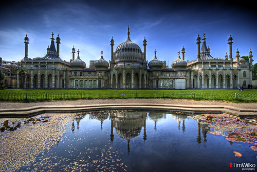
The Royal Pavilion, Brighton UK


The Royal Pavilion, originally uploaded by Tim Wilko.

The Royal Pavilion is a former royal residence located in Brighton, England. It was built in the early 19th Century as a seaside retreat for the then Prince Regent. It is often referred to as the Brighton Pavilion. It is built in the Indo-Saracenic style prevalent in India for most of the 19th Century.


"A journey of a thousand miles must begin with a single step." -- Lao Tzu
Copyright © Demetrios the Traveler


Digg!


Saturday, January 23, 2010

Cir Mhor & Glenrosa Water, Scotland, UK


Cir Mhor & Glenrosa Water, originally uploaded by antsplan.

A very impromptu, last minute trip across to Arran with David. Great day for the soul as its a gorgeous glen but I'm still really struggling to get into the landscape stuff. I shot lots of frames but on review my compositions are sloppy at best, its just not happening for me just now. Perhaps I'm expecting too much, I suspect so. Time to slow down and concentrate on continuing to learn & hopefully improve.


"A journey of a thousand miles must begin with a single step." -- Lao Tzu
Copyright © Demetrios the Traveler

Friday, October 30, 2009

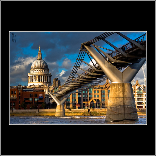
Millenium bridge of London UK


Millenium bridge of London, originally uploaded by Mr.GG.

The London Millennium Footbridge is a pedestrian-only steel suspension bridge crossing the River Thames in London, England, linking Bankside with the City. It is located between Southwark Bridge (downstream) and Blackfriars Railway Bridge (upstream). The bridge is owned and maintained by the Bridge House Estates, a charitable trust overseen by the City of London Corporation. Construction of the bridge began in 1998, with the opening on 10th June 2000.
Londoners nicknamed the bridge the Wobbly Bridge after participants in a special event to open the bridge (a charity walk on behalf of Save the Children) felt an unexpected (and, for some, uncomfortable) swaying motion on the first two days after the bridge opened. The bridge was closed later that day, and after two days of limited access the bridge was closed for almost two years while modifications were made to eliminate the wobble entirely. It was reopened in 2002.
The southern end of the bridge is near Globe Theatre, the Bankside Gallery and Tate Modern, the north end next to the City of London School below St Paul's Cathedral. The bridge alignment is such that a clear view of St Paul's south facade is presented from across the river, framed by the bridge supports.


"A journey of a thousand miles must begin with a single step." -- Lao Tzu
Copyright © Demetrios the Traveler


Digg!


readers

labels and tags

Powered By Blogger