σε κάτι λιγότερο από 48 ώρες αρχίζει η καλοκαιρινή περιπέτεια, θα μου λείψετε... θα προσπαθήσω να σας στέλνω ανταποκρίσεις... αλλά φέτος θέλω να κάνω αποτοξίνωση από το διαδίκτυο, για να δούμε θα τα καταφέρω!
============================
in less than 48hrs and for few weeks, we will be on "vacation mode"...
put "on" the summer mode all of you!
enjoy your vacations !!
Wednesday, June 30, 2010
see you ....
Tuesday, June 15, 2010
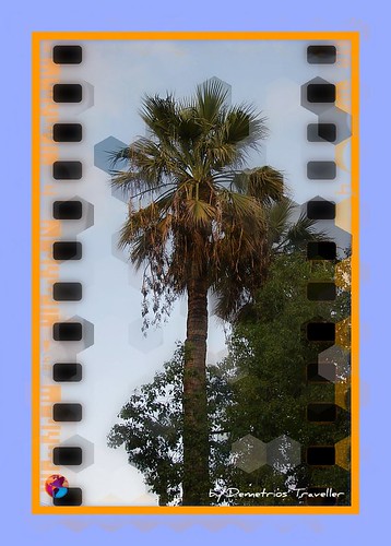
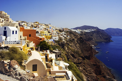
Greek Islands...αιγιοπελαγιτικα τοπια...το καλοκαιρι ειναι κοντα
Στη Μύκονο, στη Σέριφο, στη Σίκινο, στη Μήλο
πετάς κυπαρισσόμηλο κι εγώ πετάω μήλο.
Στην Αμοργό, στην Κίμωλο στη Νιό στη Σαντορίνη
μου στέλνεις κιτρολέμονο σου στέλνω μανταρίνι.
Παράγγειλα του κύρη σου που πίνει τον καφέ του
να σ έχει μαντζουράνα του να σ έχει κατιφέ του.
Παράγγειλα της μάνας σου που πλένει στο σκαφίδι
να μη σου λέει πικρόλογα τι θα τη φάει το φίδι.
Να δώσει η Μεγαλόχαρη κι η Παναγιά η Κανάλα
να μεγαλώσεις γρήγορα σαν τα κορίτσια τ άλλα.
Και τ' Αγιο-Λιός ανήμερα στη Νάξο και στην Πάρο
να δώσει η Καλαμιώτισσα γυναίκα να σε πάρω.
Παράγγειλα του κύρη σου που ρίχνει παραγάδι
να 'ρθεί να κουβεντιάσουμε την Κυριακή το βράδυ.
Παράγγειλα στη μάνα σου που μοιάζει με βαρέλι
να σε ποτίζει αφρόγαλο να σε ταΐζει μέλι.
Στη Μύκονο, στη Σέριφο, στη Σίκινο, στη Μήλο
πετάς κυπαρισσόμηλο κι εγώ πετάω μήλο.
Στην Αμοργό, στην Κίμωλο στη Νιό στη Σαντορίνη
μου στέλνεις κιτρολέμονο σου στέλνω μανταρίνι.
Στίχοι: Νίκος Γκάτσος
Μουσική: Μάνος Χατζιδάκις
Ερμηνευτής: Μανόλης Μητσιάς


"A journey of a thousand miles must begin with a single step." -- Lao Tzu
Copyright © Demetrios the Traveler
Monday, June 14, 2010
Tower bridge, London UK
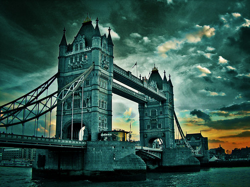
source: Wikipedia
Photo Soundtrack: "Final Battle", from Van Helsing. (Composed by Alan Silvestri).
30 secs audio clip (real audio) here.
Complete audio clip (mp3 24 kbps) here.
See more info about Photo Soundtrack here.
30 secs audio clip (real audio) here.
Complete audio clip (mp3 24 kbps) here.
See more info about Photo Soundtrack here.
"A journey of a thousand miles must begin with a single step." -- Lao Tzu
Copyright © Demetrios the Traveler
Lamberts Castle, Dorset, UK

A walk around Lamberts Castle offers stunning views of the Marshwood Vale with its clay valleys and rolling greens and hills. On a clear day you can see Chesil beach and Portland to the east and out toward the sea at Charmouth to the south.
Lambert's Castle is an Iron Age hill fort in Dorset, England, United Kingdom.
The fort rises to a height of 256 m on a broad northerly spur, with steep natural slopes on three sides, and linear ramparts across the flat southern approaches.
The site is owned by the National Trust. The is a car park accessible down a track off the B3165 east of Axminster. Coney's Castle is about 1.5 km to the south, and Pilsdon Pen about 5 km to the north-east.
It is also a Site of Special Scientific Interest on account of its geology, archaeology and ecology. It was notified as an SSSI in 1981.

Main hillfort with repairs to the ramparts Photo: NATIONAL TRUST
more @: Lambert's castle
and @: Lamberts Castle, Dorset: Walk of the week - Telegraph
"A journey of a thousand miles must begin with a single step." -- Lao Tzu Copyright © Demetrios the Traveler
5 "HOT Summer" Deals
Go island hopping in Greece, stay at a beachfront hotel in Bali, plus three more discounted getaways around the world.
All prices are per person and, if lodging is a component of the package, based upon two people traveling together (unless otherwise noted). The prices listed are general starting rates; see "What Else You'll Have to Pay" for details about associated taxes and fees. Base-prices, taxes, and fees can vary based on point of departure and time of travel. Trip add-ons like sightseeing tours and meal plans may also increase the price. Check with the tour operator for additional gateways and any single supplements, which is the extra cost that a solo traveler would pay to book the deal.

Photo Caption: The waterfront in Mykonos, Greece.
Photo by Helen Weismeyer/Frommers.com Community
Read more: Frommer's 5 Deals for June 9, 2010 Slideshow at Frommer's
"A journey of a thousand miles must begin with a single step." -- Lao Tzu Copyright © Demetrios the Traveler
Tuesday, June 8, 2010
see you in few days

Sunday, June 6, 2010
Monastiraki sq., Athens Greece

Monastiraki (Greek: Μοναστηράκι, literally little monastery) is a flea market neighborhood in the old town of Athens, Greece, and is one of the principal shopping districts in Athens. The area is home to clothing boutiques, souvenir shops, and specialty stores, and is a major tourist attraction in Athens and Attica for bargain shopping. The area is named after Monastiraki Square, which in turn is named for the Pantánassa church monastery that is located within the square. The main streets of this area are Pandrossou Street and Adrianou Street.
"A journey of a thousand miles must begin with a single step." -- Lao Tzu Copyright © Demetrios the Traveler *Placid, Oregon, USA
*placid [ˈplæsɪd]
adj
having a calm appearance or nature
[from Latin placidus peaceful; related to placēre to please]
=========================
Oregon is a state in the Pacific Northwest region of the United States. It is located on the Pacific coast, with Washington to the north, California to the south, Nevada on the southeast and Idaho to the east. The Columbia and Snake rivers delineate much of Oregon's northern and eastern boundaries respectively.
The area was inhabited by many indigenous tribes before the arrival of traders, explorers and settlers who formed an autonomous government in Oregon Country in 1843; the Oregon Territory was created in 1848, and Oregon became the 33rd state on February 14, 1859. Salem is the state's capital and third-most-populous city; Portland is the most populous. Portland is the 30th-largest U.S. city, with a population of 582,130 (2009 estimate) and a metro population of 2,241,841 (2009 estimate), the 23rd-largest U.S. metro area.
The valley of the Willamette River in western Oregon is the most densely populated and agriculturally productive region of the state, and is home to eight of the ten most populous cities. Oregon's 2000 population was about 3.5 million, a 20.3% increase over 1990; it is estimated to have reached 3.8 million by 2008. Oregon's largest for-profit private employer is Intel, located in the Silicon Forest area on Portland's west side.
The state has 199 public school districts, with Portland Public Schools as the largest. There are 17 community colleges, and seven publicly financed colleges in the Oregon University System. Oregon State University in Corvallis and the University of Oregon in Eugene are the two flagship universities of the state, while Portland State University has the largest enrollment.
Major highways include Interstate 5 which runs the entire north-south length of the state, Interstate 84 that runs east-west, U.S. Route 97 that crosses the middle of the state, U.S. Route 101 that travels the entire coastline, and U.S. Route 20 and U.S. Route 26 that run east-west, among many other highways. Portland International Airport is the busiest commercial airport in the state and is operated as part of the Port of Portland, the state's busiest port. Rail service includes Union Pacific Railroad and BNSF Railway freight service, Amtrak passenger service, as well as light rail and street car routes in the Portland metro area.
Oregon enjoys a diverse landscape including a scenic and windswept Pacific coastline, the volcanoes of a rugged and glaciated Cascade Mountain Range, dense evergreen forests, and high desert across much of the eastern portion of the state. The towering Douglas firs and redwoods along the rainy Western Oregon coast provide a dramatic contrast with the lower density and fire prone pine tree and juniper forests covering portions of the Eastern half of the state. The eastern portion of the state also includes semi-arid scrublands, prairies, deserts, and meadows. These drier areas stretch east from Central Oregon. Mount Hood is the highest point in the state at 11,249 feet (3,429 m). Crater Lake National Park is the only national park in Oregon. Oregon is the United States' leader in forest fires[citation needed]; in 2007 the state had more than 1,000 of them.
more @: http://en.wikipedia.org/wiki/Oregon
"A journey of a thousand miles must begin with a single step." -- Lao Tzu Copyright © Demetrios the Traveler
Suns up, all about NYC, USA
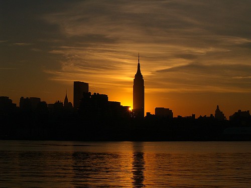
all about New York
http://www.december.com/places/nyc/blue.html
http://www.december.com/places/nyc/blue.html
"A journey of a thousand miles must begin with a single step." -- Lao Tzu Copyright © Demetrios the Traveler
Fort St Angelo, Birgu, Malta.
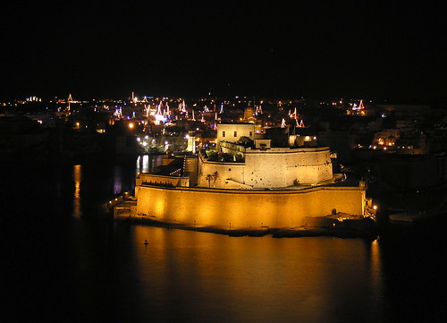
Fort St Angelo is a large fortification in Birgu, Malta.
The date of its original construction is unknown and may date back to Roman times. It certainly existed in the early medieval period. The remains of a tower that may date back to the 11th century when Malta was under Arab control can be traced among the more recent works. From the 14th century the Maltese Islands were under Aragonese rule and the fortification was known as Castello a Mare (Castle by the sea) and it was home to the powerful Nava family, feudal lords of the island.
When the the Knights of Malta arrived in Malta in 1530, they chose to settle in Birgu, and Fort St Angelo became the seat of the Grand Master. The Knights made this their primary fortification and substantially reinforced and remodelled it. Fort St Angelo withstood the Turks during the Siege of Malta, though in the aftermath of that siege the Knights built the fortified city of Valletta on Mount Sciberras across the other side of Grand Harbour, and the administrative centre for the knights moved there.
With the coming of the British to Malta the fort retained its importance as a military installation, and the fort was listed as a ship, originally in 1912 as HMS Egremont, but in 1933 renamed as HMS St Angelo. When the Royal Navy left Malta in 1979 the Fort was handed to the Maltese government and since then parts of the Fort have fallen into a state of disrepair.
Today some parts of the fort are leased to the Order of the Knights of St John. Other parts are used as a maritime Museum and most recently commercial development has taken place along the quayside.
The fortification has also undergone some recent repair, though not all parties seem to view this as having been done sympathetically to the site.
"A journey of a thousand miles must begin with a single step." -- Lao Tzu Copyright © Demetrios the Traveler The date of its original construction is unknown and may date back to Roman times. It certainly existed in the early medieval period. The remains of a tower that may date back to the 11th century when Malta was under Arab control can be traced among the more recent works. From the 14th century the Maltese Islands were under Aragonese rule and the fortification was known as Castello a Mare (Castle by the sea) and it was home to the powerful Nava family, feudal lords of the island.
When the the Knights of Malta arrived in Malta in 1530, they chose to settle in Birgu, and Fort St Angelo became the seat of the Grand Master. The Knights made this their primary fortification and substantially reinforced and remodelled it. Fort St Angelo withstood the Turks during the Siege of Malta, though in the aftermath of that siege the Knights built the fortified city of Valletta on Mount Sciberras across the other side of Grand Harbour, and the administrative centre for the knights moved there.
With the coming of the British to Malta the fort retained its importance as a military installation, and the fort was listed as a ship, originally in 1912 as HMS Egremont, but in 1933 renamed as HMS St Angelo. When the Royal Navy left Malta in 1979 the Fort was handed to the Maltese government and since then parts of the Fort have fallen into a state of disrepair.
Today some parts of the fort are leased to the Order of the Knights of St John. Other parts are used as a maritime Museum and most recently commercial development has taken place along the quayside.
The fortification has also undergone some recent repair, though not all parties seem to view this as having been done sympathetically to the site.
Sarawak Culture, Borneo, Malaysia
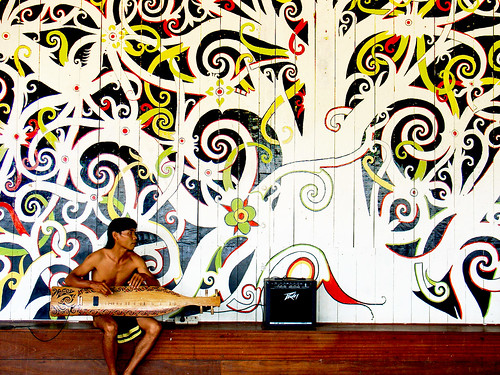
Sarawak is Malaysia's largest state. It lies in East Malaysia and shares the island of Borneo with the eastern state of Sabah, the separate country of Brunei and the Indonesian provinces of Kalimantan.
The Sarawak Cultural Village is sandwiched between Holiday Inn Damai Lagoon and Holiday Inn Damai Beach Resort. Walking from these two resorts is possible. From Kuching, the journey takes about 45 minutes through the spectacular peninsula of Santubong at which Damai seaside resorts are located. Taxi hire from downtown Kuching is possible but it can cost you a lot. Then there is a question of getting a taxi back to Kuching after you have finished visiting all the attractions the village. There will be an exorbitant surcharge should you require the taxi driver to wait for your return trip.
Caldera
A caldera is a volcanic feature formed by the collapse of land following a volcanic eruption. They are often confused with volcanic craters. The word 'caldera' comes from the Spanish language, meaning "cauldron".
Caldera formation
A collapse is triggered by the emptying of the magma chamber beneath the volcano, usually as the result of a large volcanic eruption. If enough magma is erupted, the emptied chamber will not be able to support the weight of the volcanic edifice (the mountain) above. Fractures will form around the edge of the chamber, usually in a roughly circular shape. These ring fractures may in fact serve as volcanic vents. As the magma chamber empties, the center of the volcano within the ring fractures begins to collapse. The collapse may occur as the result of a single massive eruption, or it may occur in stages as the result of a series of eruptions. The total area that collapses may be hundreds or thousands of square kilometers.
Explosive calderas
If the magma is rich in silica, the caldera is often filled in with ignimbrite, tuff, rhyolite, and other igneous rocks. Silica-rich magma is very viscous. As a result, gases tend to become trapped at high pressure within the magma. When the magma gets near the surface of the Earth, the gas expands quickly, causing explosions and spreading volcanic ash over wide areas. Further lava flows may be erupted, and the center of the caldera is often uplifted in the form of a resurgent dome by subsequent intrusion of magma. A silicic or rhyolitic caldera may erupt hundreds or even thousands of cubic kilometers of material in a single event. Even small caldera-forming eruptions, such as Krakatoa in 1883 or Mount Pinatubo in 1991, may result in significant local destruction and a noticeable drop in temperature around the world. Large calderas may have even greater effects.
When Yellowstone Caldera (last) erupted 640,000 years ago it released 1,000 cubic kilometers of material, covering all of North America in up to two meters of debris. By comparison, when Mount St. Helens erupted in 1980, it released 1.2 cubic kilometers of ejecta. The ecological effects of the eruption of a large caldera can be seen in the record of the Lake Toba eruption in Indonesia. About 75,000 years ago, this volcano released 2,800 cubic kilometers of ejecta, the largest known eruption within the Quaternary Period (last 1.8 million years). In the late 1990s, archeologist Stanley Ambrose proposed that a volcanic winter induced by this eruption reduced the human population to a few thousand individuals, resulting in a population bottleneck (see Toba catastrophe theory). Even larger caldera-forming eruptions are known, especially La Garita Caldera in the San Juan Mountains of Colorado, where the 5,000 cubic kilometer Fish Canyon Tuff was blasted out in a truly major single eruption 27.8 million years ago.
At some points in geologic time, rhyolitic calderas have appeared in distinct clusters. The remnants of such clusters may be found in places such as the San Juan Mountains of Colorado (erupted during the Tertiary Period) or the Saint Francois Mountain Range of Missouri (erupted during the Proterozoic).
Non-explosive calderas
Some volcanoes, such as Kīlauea on the island of Hawaii, form calderas in a different fashion. In the case of Kilauea, the magma feeding the volcano is relatively silica poor. As a result, the magma is much less viscous than the magma of a rhyolitic volcano, and the magma chamber is drained by large lava flows rather than by explosive events. The resulting calderas are also known as subsidence calderas, and can form more gradually than explosive calderas. For instance, the caldera atop Fernandina Island underwent a collapse in 1968, when parts of the caldera floor dropped 350 meters. Kilauea Caldera has an inner crater known as Halema‘uma‘u, which has often been filled by a lava lake. The largest volcano on Earth, Mauna Loa is also capped by a subsidence caldera called Moku‘āweoweo Caldera.
From Wikipedia, the free encyclopedia
"A journey of a thousand miles must begin with a single step." -- Lao Tzu Copyright © Demetrios the Traveler
Typical house of Santana, northern Madeira Island, Portugal
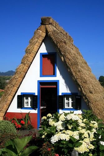
Santana is a city located in the northern part of the Madeira Islands, Portugal. It is located north of Funchal, northwest of the Machico, east of São Vicente and northeast of Câmara de Lobos.
The main sources of industry are agriculture and tourism, and a small number of businesses are in the downtown area. A large theme park is also located in the center of town, which includes some exhibits about the island and its culture. The Madeira Theme Park is an ample space on 7 acres (28,000 m2) of land, where visitors of all ages can embark on a voyage of discovery throughout Madeira and Porto Santo. Visitors can learn about the island's history, familiarize themselves with the local traditions and culture, vibrate with the exceptional beauty of the landscapes, explore an immense park-garden and feel the unique force of nature.
Santana is famous for its traditional homes with bungalow rooftops that are made out of straw that extend down to the ground, making them triangular in shape. They are mainly rural houses, used by farmers in the past. These houses have white walls with red doors and windows and blue trim. Most of these houses are tourist attractions. The straw roofs are renovated every four to five years.
These strawroofed houses are disappearing, replaced by those made of concrete according to current tastes.
The roof covers the house to the ground in order to protect it from the strong cold winds of the Northern Atlantic.
Flowers in small garden patches in front of each house add even more colour to the scenery.
source: wikipedia
more info @ : http://www.cm-santana.com/cmsantana/
Elavador de Sta. Justa - Lisbon - Portugal
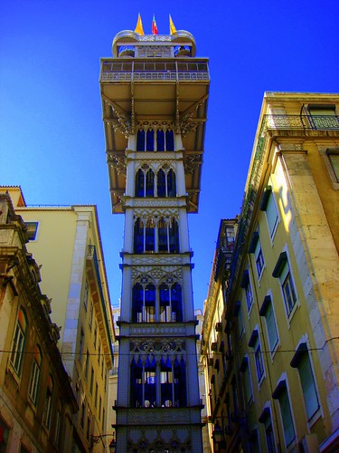
The Santa Justa Lift, also called Carmo Lift (Elevador do Carmo, [elɨvɐˈdoɾ du ˈkaɾmu]), is a lift in the city of Lisbon situated at the end of Rua de Santa Justa. It connects the lower streets of the Baixa with the higher Largo do Carmo (Carmo Square.)
Neogothic structure of the Santa Justa Lift. The bridge leads to the Carmo Square.
The Santa Justa Lift was designed by Raul Mesnier de Ponsard, an engineer born in Porto to French parents, and apprentice of Gustave Eiffel[citation needed]. Construction began in 1900 and was finished in 1902; originally powered by steam, it was converted to electrical operation in 1907.
The iron lift is 45 metres tall and is decorated in neogothic style, with a different pattern on each storey. The top storey is reached by helicoidal staircases and has a terrace that offers views of Lisbon Castle, the Rossio Square and the Baixa neighbourhood. There are two lift cages, each with a wooden interior and accommodation for a maximum of 20 passengers.
The lift has become a tourist attraction in Lisbon as, among the urban lifts in Lisbon, Santa Justa is the only vertical one. Others, including Elevador da Glória and Elevador da Lavra, are more like funiculars that help climb the slopes of Lisbon.
Monaco Ville on the Rocks!
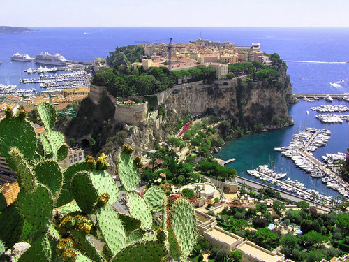
Monaco-Ville is the original fortified town of Monaco. The Palais Princier (Prince's Palace), Saint Nicholas Cathedral, and the Oceanographic Museum are located in this quarter. Monaco-Ville, also known locally as "le rocher" or "the rock". Some of the city walls still remain and is situated on a rocky promontory that extends into the Mediterranean Sea.
Bonifacio, island of Corsica, France
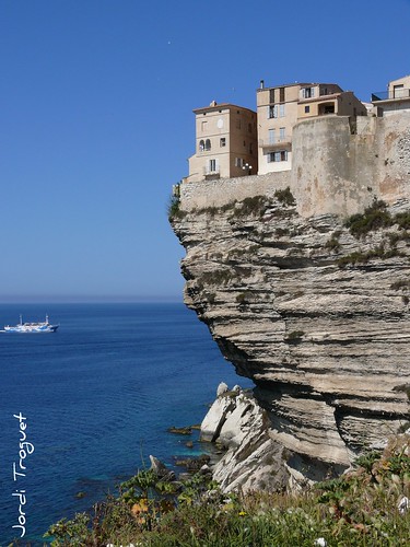
, in the Corse-du-Sud department of France. Its inhabitants are called Bonifaciens, feminine Bonifaciennes. The commune in this case is identical to the canton and is the largest commune of Corsica.
Bonifacio is located directly on the Mediterranean Sea, separated from Sardinia by the Strait of Bonifacio. It is a city placed on the best and only major harbor of the southern coast and also is a commune covering a somewhat larger region including the offshore Isles Lavezzi, giving it the distinction of being the southernmost commune in Metropolitan France. The commune is bordered on the northwest by the canton of Figari and has a short border on the northeast with the canton of Porto-Vecchio. The combined border runs approximately from the Golfe de Ventilegne on the west to the mouth of the Golfu di Sant'Amanza on the east. The coastline circumscribed by the two points is about 75 kilometres (47 mi). Highway N198 runs north along the east coast and N196 along the west.
The islands are part of the French portion, 794.6-square-kilometre (196,300-acre), of the international Bouches de Bonifacio ("Strait of Bonifacio") marine park, a nature reserve, signed into legal existence by France and Italy in 1993 for the protection of the strait against passage of ships bearing dangerous chemicals, and implemented in France by a ministerial decree of 1999 detailing the land to be included in the réserve naturelle de Bouches de Bonifacio for the preservation of wild birds, other fauna and flora, fish and nature in general.
The southern coast in the vicinity of Bonifacio is an outcrop of chalk-white limetone, precipitous and sculpted into unusual shapes by the ocean. Slightly further inland the limestone adjoins the granite of which the two islands, Sardinia and Corsica, are formed. The port of Bonifacio is placed on the Bay of Bonifacio, a drowned ravine of a fjord-like appearance separated from the ocean by a finger-like promontory 1,500 meters (4,900 ft) long and 200 meters (660 ft) wide. In prehistoric post-glacial times when sea levels were low and the islands were connected, the ravine was part of a valley leading to upland Corsica. The maximum draught supported by the harbor is 3.5 meters (11 ft), more than ample for ancient ships and modern small vessels.
The city of Bonifacio is split into two sections. The vieille ville (old town), or la Haute Ville (the Upper city), on the site of a citadel, is located on the promontory overlooking the Mediterranean Sea. The citadel was built in the 9th century with the foundation of the city. The Citadel has been reconstructed and renovated many times since its construction and most recently was an administrative center for the French Foreign Legion. Today it is more of a museum. Historically most of the inhabitants have resided in the Haute ville under the immediate protection of the citadel. The harbor facilities and residential areas below, la marine, line the narrow shelf of the inlet and extend for some distance up the valley, giving the settlement a linear appearance and creating a third residential section limited by St. Julien on the east.
The city and its fortifications also extend for some distance along the cliff-tops, which are at about 70 meters (230 ft) elevation. The cliffs have been undercut by the ocean so that the buildings, which have been placed on the very lip of the precipice, appear to overhang it. The appearance from the sea is of a white city gleaming in the sun and suspended over the rough waters below.
source: http://en.wikipedia.org/wiki/Bonifacio
Tanah Lot Temple, Indonesia, Bali
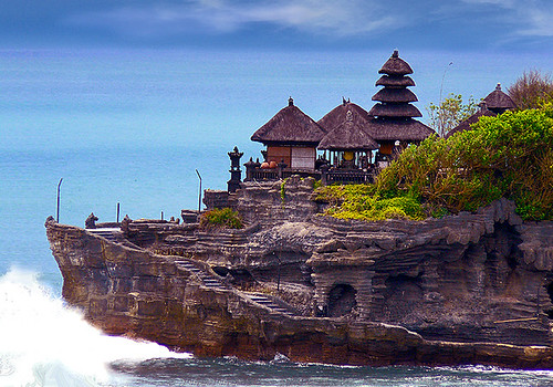
Tanah Lot is a rock formation off the Indonesian island of Bali. It is home of a pilgrimage temple, the Pura Tanah Lot (literally "Tanah Lot temple") and a popular tourist and cultural icon for photography and general exoticism.
Pura Tanah Lot (Tanah Lot Temple) is Hindu Temple.
Located about 20 km from Denpasar, the temple sits on a huge offshore rock which has been shaped continuously over the years by the ocean tide.
Tanah Lot means "Land in the Middle of the Sea" (in Balinese language) is a famous rock formation off the Indonesian island of Bali.
Note: It is a fantastic place to view beautiful dramatic sunsets. Every day at dusk, tourists throng the area to witness the magnificent silhouette of the temple against the glowing horizon.
more: @
Colorado Balloon Classic , USA

The event is held in Memorial Park off Pikes Peak Avenue between Hancock Ave. and Union Blvd near the shores of Prospect Lake. Mass ascensions with over 100 balloons are scheduled for Saturday, Sunday and Monday mornings with a Balloon Glo® scheduled for Saturday and Sunday evenings. Each year a variety of concessions are available and entertainment is provided during each event.
The Colorado Balloon Classic (a division of Colorado Springs Balloon Classic, Inc.) was organized in 1977 and has grown to be the largest and the longest continuously running hot air balloon festival in the Rocky Mountain Region as well as the State of Colorado. The Colorado Balloon Classic is an annual family event - admission is free - held each Labor Day weekend.
Saturday, June 5, 2010
A380 Touching Down

Lufthansa's new Airbus A380 D-AIMA arrived at DUS as part of the pilot qualification in advance of its first commercial flight on 6-Jun-2010 taking the German soccer team to Johannesburg for the World Cup
Sunset at Fort Kochi, Kerala, India
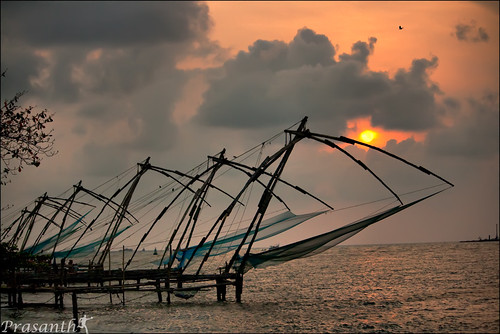
Kochi, formerly known as Cochin, is a city in the Indian state of Kerala. Kochi or Cochin is popularly known as the Queen of Arabian Sea, also flaunts one of the finest natural harbours of the world, and was the centre of the world spice trade for many centuries. Old Kochi loosely refers to a group of islands which comprise Willingdon Island, Fort Kochi, Mattancherry, etc.
Today Kochi includes Ernakulam city, old parts of Kochi, Kumbalangi, and outlying islands. It is one of the principal tourist destinations of Kerala. The city derives its name from the Malayalam word Kochazhi meaning small lagoon.
more about attractions around and inf @ : http://en.wikipedia.org/wiki/List_of_Tourist_attractions_in_Kochi
The castle of Horst, Belgium.
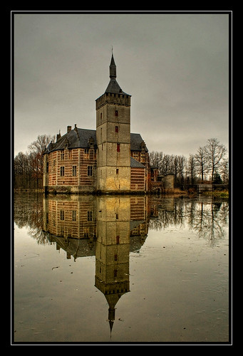
The home of the red knight!!
Horst Castle lies near the village of St. Pietersrode, north-east of the city of Brussels in Belgium.
When the first Horst Castle was built isn't known. And however there was a 'castellum Rode' in this area in the 11th century, the name Horst was first mentioned in 1263. Then a Jan van Thunen settled here and called himself Jan van Horst.
Horst Castle was built on a strategic spot in the Winge-valley and was one of the strenghts protecting the nearby city of Leuven which was the largest and most important city in the Duchy of Brabant during the 14th century.
In 1369 the castle was bought by an Amelric Boote who rebuilt it. Of his stronghold only the keep, part of the curtain wall and a part of the gate remains.
In 1488/89 the castle was burnt down by the people of Leuven during their war against Maximillian of Austria. Around 1490 the castle was rebuilt to its present appearance by a Lodewijk Pynnock. Before he could finish the castle he had to sell it in 1500, due to financial difficulties.
The new owner was Iwein van Kortenbach which caused the castle to come in the sphere of the town of Mechelen rather than Leuven.
In 1521 the castle was sold again, this time to the Van Buysleyden family. But this family also came into financial difficulties and had to sell the castle in the 17th century. This time it was sold to an Olivier van Schoonhoven who finally finished the rebuilding of the castle.
In 1630 Maria-Anna van den Tympel inherited the castle. She is the one who made the stucco ceilings in the three halls and was the last owner actually residing in the castle.
In the following centuries the ownership of the castle changed several times through inheritance. The new owners however weren't interested in the castle which had gotten out of fashion. The castle was mostly maintained by caretakers.
Nowadays the castle stands empty. During your visit you can walk through its halls and climb the keep all the way to the top through a narrow wall staircase. There is a little shop and a restaurant in the former coach-house on the bailey.
source: http://www.castles.nl/eur/be/hor/hor.html
Predjamski Grad / Predjama Castle, Slovenia
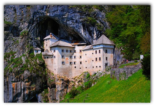
The castle was first mentioned in year 1274, then named Luegg, when Aquileian patriarchs built the castle in gothic style. The castle was built under a natural rocky arch high in the stone wall to make access to it difficult. It was later annexed and re-shaped by family Luegg, also called Predjama knights. Erazem, who was the owner of the castle in 15th century, and a renowned robber, later joined king Matthias Corvinus, for which the current Emperor ordered Gašper Ravbar to assassinate him. After a long siege of the castle, Erazem was finally killed in 1483 by being tricked. The castle has fallen under Oberburg and Purgstall power.
In 1567 archduke Karel leased the castle to baron Philipp von Cobenzl, who bought off the castle after 20 years. He annexed the castle as early as 1570 and built a renaissance building, pressed next to a vertical cliff under the castle. The castle remained in such form until today. Count Michael Coronini von Cronberg inherited the castle in 1810 and it was property of family Windischgrätz from 1846 until the end of World War II. After the war it was nationalized and is now used as a museum for showing the life of medieval lords.
A secret natural shaft leads out of the castle, which Erazem ordered to be enlarged, and leads into Postojnska jama. This shaft allowed Erazem to secretly supply the castle with food in the time of the siege; he also used it to continue with his robberies.
Predjama Castle was used as the castle featured in the 1986 movie Armour of God by Golden Harvest starring Jackie Chan. It was also investigated for paranormal activity in a 2008 episode of Ghost Hunters International on the Sci Fi Channel.
Palácio Nacional da Pena, Sintra Portugal

The Pena National Palace (Portuguese: Palácio Nacional da Pena) is the oldest palace inspired by European Romanticism. It is located in the civil parish of São Pedro de Penaferrim, municipality of Sintra, Portugal.
The palace stands on the top of a hill above the town of Sintra, and on a clear day it can be easily seen from Lisbon and much of its metropolitan area. It is a national monument and constitutes one of the major expressions of 19th century Romanticism in the world.
The palace is a UNESCO World Heritage Site and one of the Seven Wonders of Portugal. It is also used for state occasions by the President of the Portuguese Republic and other government officials.
more @ http://en.wikipedia.org/wiki/Pena_National_Palace
The Crooked House, Dudley UK
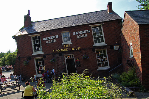
This is the Crooked House or the Glynne Arms at Himley. In the past it has suffered badly from mining subsidence. It lies on what was the divide between Sir Stephen Glynne's land and that of the Earl of Dudley.
Glynne removed too much of the coal that lies underneath, and the building began to sink. However, after been propped up, the interior was extensively altered to create an optical illusion. Here is a place where golf balls roll uphill!
"A journey of a thousand miles must begin with a single step." -- Lao Tzu Copyright © Demetrios the Traveler Glynne removed too much of the coal that lies underneath, and the building began to sink. However, after been propped up, the interior was extensively altered to create an optical illusion. Here is a place where golf balls roll uphill!
Thursday, June 3, 2010
bring me home
"A journey of a thousand miles must begin with a single step." -- Lao Tzu Copyright © Demetrios the Traveler

Subscribe to:
Posts (Atom)

movable bridge of the double-leaf bascule (drawbridge) type that spans the River Thames between the Greater London boroughs of Tower Hamlets and Southwark. It is a distinct landmark that aesthetically complements the Tower of London, which it adjoins.
The bridge was completed in 1894 and provides an opening 250 feet (76 metres) wide. Its twin towers rise 200 feet (61 metres) above the Thames.
Between the towers stretch a pair of glass-covered walkways that are popular among tourists. The walkways were originally designed to allow pedestrians to cross even while the bridge was raised, but they became hangouts for prostitutes and thieves and so were closed from 1909 to 1982.
The Tower Bridge was operated by hydraulic pumps driven by steam until 1976, when electric motors were put into operation; the steam power system is still kept (in good repair) as a tourist display. Because of the reduction in shipping at the London Docklands, however, the leaves are now seldom raised.