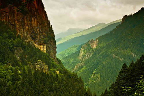
The Sümela Monastery (Turkish: Sümela Manastırı), Greek: Μονή Παναγίας Σουμελά, i.e. monastery of the Panaghia ("All Holy", the Greek name for the Virgin Mary) at Melá mountain) is a Greek Orthodox monastery, standing at the foot of a steep cliff facing the Altındere valley, in the region of Maçka in Trabzon Province, modern Turkey. Lying at an altitude of approximately 1200 metres, it is a major tourist attraction of Altındere National Park.
Showing posts with label photography. Show all posts
Showing posts with label photography. Show all posts
Thursday, February 9, 2012
Sümela Monastery, Trabzon, Turkey
The Sümela Monastery (Turkish: Sümela Manastırı), Greek: Μονή Παναγίας Σουμελά, i.e. monastery of the Panaghia ("All Holy", the Greek name for the Virgin Mary) at Melá mountain) is a Greek Orthodox monastery, standing at the foot of a steep cliff facing the Altındere valley, in the region of Maçka in Trabzon Province, modern Turkey. Lying at an altitude of approximately 1200 metres, it is a major tourist attraction of Altındere National Park.

Tuesday, January 17, 2012
Oxford, England, UK
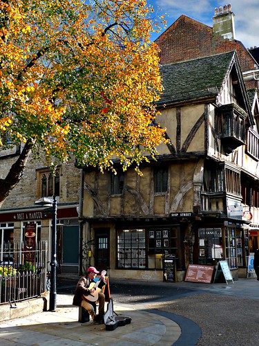
Oxford is the oldest university city in the United Kingdom, situated some 50 miles (80 km) to the west of the capital London in its own county of Oxfordshire, and located on the rivers Thames (the section of the Thames in Oxford is known as "The Isis") and Cherwell. Together with Cambridge (the second oldest university city and Oxford's great rival), Oxford has long represented the British academic establishment and élite ("Oxbridge"), a haven of tradition and endeavour. Oxford's famous "Dreaming Spires" refer to the medieval churches and colleges that dominate the bustling modern town in all their Gothic splendour. Picturesque architecture and a vibrant modern life (driven by students, light industry and technology) set in the rolling countryside of Oxfordshire make this a great destination.
via Wikipedia
via Wikipedia
Monday, January 2, 2012
Kos - Kastri Islet, Aegean Sea, Greece
Kos - Kastri Islet
The island has several sandy coasts. The beaches in the north side of the island are more affected by winds. Most of the coasts underwent touristic development and have easy access and various services. Some of the most visited beaches are: Nomikou-Barbagianni sandy beach extending from the city of Kos to the surrounding areas. It is an organized beach with umbrellas and deck-chairs, water sports, restaurants and bars. Zourouni sandy beach is an organized beach with umbrellas and deck-chairs, water sports, bars and loud music. Nautical Club beach with fine sand is awarded with the European Union blue flag. Milos beach with fine sand, which is also awarded with European Union blue flag. There is a coastal bar with loud music and frequent concerts.

The island has several sandy coasts. The beaches in the north side of the island are more affected by winds. Most of the coasts underwent touristic development and have easy access and various services. Some of the most visited beaches are: Nomikou-Barbagianni sandy beach extending from the city of Kos to the surrounding areas. It is an organized beach with umbrellas and deck-chairs, water sports, restaurants and bars. Zourouni sandy beach is an organized beach with umbrellas and deck-chairs, water sports, bars and loud music. Nautical Club beach with fine sand is awarded with the European Union blue flag. Milos beach with fine sand, which is also awarded with European Union blue flag. There is a coastal bar with loud music and frequent concerts.
Sunday, November 20, 2011
Greenland Dock , London UK
 |
| photo via Roman Gerodimos |
Greenland Dock is the oldest of London's riverside wet docks, located in Rotherhithe in the area of the city now known as Docklands. It used to be part of the Surrey Commercial Docks, most of which have by now been filled in. Greenland Dock is now used purely for recreational purposes; it is one of only two functioning enclosed docks on the south bank of the River Thames.
"A journey of a thousand miles must begin with a single step." -- Lao Tzu Copyright © Demetrios the Traveler
The dock was originally laid out between 1695-99 on land owned by the aristocratic Russell family of the 1st Duke of Bedford. The Russells had been given a portion of land in lower Rotherhithe by a wealthy Streatham landowner, John Howland, as part of a wedding dowry for his daughter Elizabeth, granddaughter of Sir Josiah Child - the dictatorial chairman of the East India Company, who married Wrothesley Russell, the Marquis of Tavistock. They immediately set about "improving" the rural property, obtaining parliamentary permission in 1695 to construct a rectangular dock with an area of about 10 acres (4.0 ha), capable of accommodating around 120 ships. It was named Howland Great Wet Dock in honour of John Howland. Designed by local shipwright, John Wells, the dock was intended to refit East India ships.
more info via Wikipedia
more info via Wikipedia
"A journey of a thousand miles must begin with a single step." -- Lao Tzu Copyright © Demetrios the Traveler
Monday, October 24, 2011
Crete from Space, Aegean Sea, Greece
The Aegean and Libyan Seas in the eastern Mediterranean are split by the island of Crete, which is seen in prominence in this Envisat image.

The image is a collation of three separate passes by the European Space Agency’s Envisat satellite on 11 December 2010, 10 January and 11 March 2011. Each pass was assigned a separate colour – red, green and then blue – and the changes in colour reveal changes in the surface between the three passes.
At the top of the image is the southern portion of the Cyclades island group, including the islands of Milos, Ios, Anafi and Santorini.
Source: European Space Agency
Source: Planetsave (http://s.tt/13AvM)
Monday, October 17, 2011
Prague, Czech Republic
 Dear Praha by Edgar Barany |
Prague is the capital and largest city of the Czech Republic. Situated in the north-west of the country on the Vltava river, the city is home to about 1.3 million people, while its metropolitan area is estimated to have a population of over 2.3 million. The city has a temperate oceanic climate with warm summers and chilly winters.
Prague has been a political, cultural and economic centre of Europe and particularly central Europe during its 1,100 year existence. For centuries, during theGothic and Renaissance eras, Prague was the permanent seat of two Holy Roman Emperors and thus was also the capital of the Holy Roman Empire. Later it was an important city in the Habsburg Monarchy and the Austro-Hungarian Empire, and after World War I became the capital of Czechoslovakia. The city played major roles in theProtestant Reformation, the Thirty Years' War, and in 20th-century history, during both World Wars and the post-war Communist era.
Prague is home to a number of famous cultural attractions, many of which survived the violence and destruction of twentieth century Europe. Main attractions include the following: Prague Castle, the Charles Bridge, Old Town Square, the Jewish Quarter, the Lennon Wall, and Petřín hill. Since 1992, the extensive historic centre of Prague has been included in the UNESCOlist of World Heritage Sites.
Prague boasts more than ten major museums, along with countless theatres, galleries, cinemas, and other historical exhibits. Also, Prague is home to a wide range of public and private schools, including the famous Charles University. Its rich history makes it a popular tourist destination, and the city receives more than 4.1 million international visitors annually, as of 2009. Prague is classified as a global city.
more via Wikipedia
"A journey of a thousand miles must begin with a single step." -- Lao Tzu Copyright © Demetrios the Traveler
Wednesday, October 12, 2011
Abandoned Casino Constanta Romania
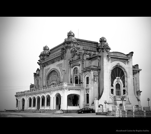
Abandoned Casino, originally uploaded by Bogdan Suditu.
Constanța (Romanian pronunciation: [konˈstant͡sa]; historical names: Tomis, Greek: Κωνστάντια, Konstantia, Bulgarian: Кюстенджа, Kyustendzha, Turkish: Köstence) is the oldest extant city inRomania, founded around 600 BC. The city is located in the Dobruja region of Romania, on the Black Sea coast. It is the capital of Constanța County and the largest city in the region.
The city of Constanța is one of the most important in Romania, one of four roughly equal-size cities which rank after Bucharest. The Constanța metropolitan area, founded in 2007, comprises 14 localities located at a maximum distance of 30 km (19 mi) from the city, and with 446,595 inhabitants it is the second largest metropolitan area in Romania, after Bucharest.
The Port of Constanța has an area of 39.26 km2 (15.16 sq mi) and a length of about 30 km (19 mi). It is the largest port on the Black Sea, and one of the largest ports in Europe.
Friday, September 30, 2011
Venice Italy from space.. a Floating city
Earth From Space: Floating city, originally uploaded by europeanspaceagency.
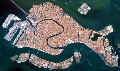
The islands that make up the Italian city of Venice and the surrounding Venetian Lagoon are pictured in this image. Snaking through the central districts is the Grand Canal, with the Santa Lucia train station at its northern end and the Saint Mark Basin at its southern end. Zooming in, we can see water buses and taxis navigating the canal and gondolas docked along the edge. The square island to the north is San Michele. Once a prison island, it became a cemetery when Napoleon’s occupying forces declared burial on the main islands unsanitary.
This image was acquired on 22 June 2008 by Ikonos-2, a commercial satellite that provides panchromatic and multispectral high-resolution imagery. ESA is supporting Ikonos-2 as a Third Party Mission, which means that the Agency uses its multi-mission European ground infrastructure and expertise to acquire, process and distribute data from the satellite to its wide scientific user community.
High resolution versions of this image can be found at: www.esa.int/esaEO/SEM44R0UDSG_index_1.html
Saturday, September 24, 2011
St. Kilda, Scotland, UK

St Kilda (Scottish Gaelic: Hiort) is an isolated archipelago 64 kilometres (40 mi) west-northwest of North Uist in the North Atlantic Ocean. It contains the westernmost islands of the Outer Hebrides of Scotland. The largest island is Hirta, whose sea cliffs are the highest in the United Kingdom. The islands are administratively a part of the Comhairle nan Eilean Siar local authority area.
St Kilda was permanently inhabited for at least two millennia, with its population probably never exceeding 180 (and certainly no more than 100 after 1851). The entire population was evacuated from Hirta (the only inhabited island) in 1930. Currently, the only year-round residents are defence personnel although a variety of conservation workers, volunteers and scientists spend time there in the summer months.
The origin of the name St Kilda is a matter of conjecture. The islands' human heritage includes numerous unique architectural features from the historic and prehistoric periods, although the earliest written records of island life date from the Late Middle Ages. The medieval village on Hirta was rebuilt in the 19th century, but the influences of religious zeal, illnesses brought by increased external contacts through tourism, and the First World War all contributed to the island's evacuation in 1930. The story of St Kilda has attracted artistic interpretations, including an opera.
The entire archipelago is owned by the National Trust for Scotland. It became one of Scotland's five World Heritage Sites in 1986 and is one of the few in the world to hold joint status for its natural and cultural qualities. Two different early sheep types have survived on these remote islands, the Soay, a Neolithic type, and the Boreray, an Iron Age type. The islands are a breeding ground for many important seabird species including Northern Gannets, Atlantic Puffins, and Northern Fulmars. The St Kilda Wren and St Kilda Field Mouse are endemic subspecies. Parties of volunteers work on the islands in the summer to restore the many ruined buildings that the native St Kildans left behind. They share the island with a small military base established in 1957.
Shiprock, New Mexico USA
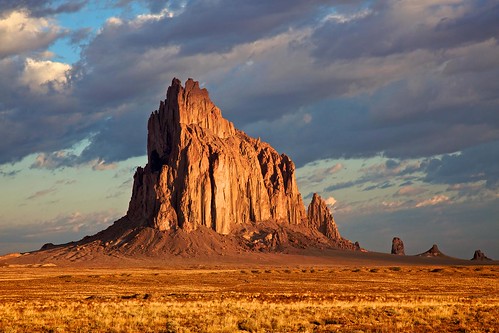
Shiprock (Navajo: Tsé Bitʼaʼí, "rock with wings" or "winged rock") is a rock formation rising nearly 1,583 feet (482.5 m) above the high-desert plain on the Navajo Nation in San Juan County, New Mexico, USA. It has a peak elevation of 7,177 feet (2,187.5 m) above the sea level. It lies about 12 by 20 miles (19 by 32 km) southwest of the town of Shiprock, which is named for the peak. Governed by the Navajo Nation, the formation is in the Four Corners region and plays a significant role in Navajo religion, mythology and tradition. It is located in the center of the Ancient Pueblo People or Ancestral Puebloan civilization, a prehistoric Native American culture of the Southwest United States often referred to as the Anasazi. Shiprock is a point of interest for rock climbers and photographers and has been featured in several film productions and novels. It is the most prominent landmark in northwestern New Mexico
Friday, September 16, 2011
Arctic Sea Ice
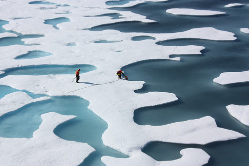
Arctic Sea Ice, originally uploaded by NASA Goddard Photo and Video.
Arctic Sea Ice
On July 12, 2011, crew from the U.S. Coast Guard Cutter Healy retrieved a canister dropped by parachute from a C-130, which brought supplies for some mid-mission fixes.
The ICESCAPE mission, or "Impacts of Climate on Ecosystems and Chemistry of the Arctic Pacific Environment," is NASA's two-year shipborne investigation to study how changing conditions in the Arctic affect the ocean's chemistry and ecosystems. The bulk of the research takes place in the Beaufort and Chukchi seas in summer 2010 and 2011.
Credit: NASA/Kathryn Hansen
For updates on the five-week ICESCAPE voyage, visit the mission blog at: go.usa.gov/WwU
NASA Goddard Space Flight Center enables NASA’s mission through four scientific endeavors: Earth Science, Heliophysics, Solar System Exploration, and Astrophysics. Goddard plays a leading role in NASA’s accomplishments by contributing compelling scientific knowledge to advance the Agency’s mission.
Tuesday, September 13, 2011
Monastiraki Square, Athens, Greece
Athens is the historical capital of Europe, with a long history, dating from the first settlement in the Neolithic age. In the 5th Century BC (the “Golden Age of Pericles”) – the culmination of Athens’ long, fascinating history – the city’s values and civilization acquired a universal significance. Over the years, a multitude of conquerors occupied Athens, and erected unique, splendid monuments - a rare historical palimpsest. In 1834, it became the capital of the modern Greek state and in two centuries since it has become an attractive modern metropolis with unrivalled charm.
Via Flickr:
Athens is the historical capital of Europe, with a long history, dating from the first settlement in the Neolithic age. In the 5th Century BC (the “Golden Age of Pericles”) – the culmination of Athens’ long, fascinating history – the city’s values and civilization acquired a universal significance. Over the years, a multitude of conquerors occupied Athens, and erected unique, splendid monuments - a rare historical palimpsest. In 1834, it became the capital of the modern Greek state and in two centuries since it has become an attractive modern metropolis with unrivalled charm.
Photo: (GNTO / Yannis Skoulas)
--
www.visitgreece.gr

Via Flickr:
Athens is the historical capital of Europe, with a long history, dating from the first settlement in the Neolithic age. In the 5th Century BC (the “Golden Age of Pericles”) – the culmination of Athens’ long, fascinating history – the city’s values and civilization acquired a universal significance. Over the years, a multitude of conquerors occupied Athens, and erected unique, splendid monuments - a rare historical palimpsest. In 1834, it became the capital of the modern Greek state and in two centuries since it has become an attractive modern metropolis with unrivalled charm.
Photo: (GNTO / Yannis Skoulas)
--
www.visitgreece.gr
one day on earth..
onedayonearth.org
ONE DAY ON EARTH creates a picture of humanity by recording a 24-hour period throughout every country in the world. We explore a greater diversity of perspectives than ever seen before on screen.
We follow characters and events that evolve throughout the day, interspersed with expansive global montages that explore the progression of life from birth, to death, to birth again. In the end, despite unprecedented challenges and tragedies throughout the world, we are reminded that every day we are alive there is hope and a choice to see a better future together.
Founded in 2008, ONE DAY ON EARTH set out to explore our planet’s identity and challenges in an attempt to answer the question: Who are we? Please help us tell this story: 101010donate.org
Many thanks to the contributors of One Day on Earth, Vimeo, Ning, United Nations, and the 60+ non-profits for making this happen.
Director: Kyle Ruddick
Producer: Brandon Litman
Co-producer: Daniel Lichtblau
Production Supervisor: Gina Nemirofsky
Editors: Michael Martinez & Javier Alvarez
Trailer Editor: Michael Martinez
MUSIC BY: Joseph Minadeo and Beirut Images and
Stories in this trailer by: 350.org Abdessamad Idrissi Ada & Kris Chmielewski Aditya Kolli Adonis Pulatus Alex M Alexander Alexandros Hadjicostas Ali Azhari Ben Klein Black Pencil Project Brandon Litman Bronek Kaminski Bryon Evans Capi Baigorria Chi Kong Lui Chris Todd Christian Ducken Clifford W Klima Daniel Chung Daniel Lichtblau David Ahrendts David Aufdembrinke Demeocq Dimitri Ellerington Dimitris Christopoulos Enrico Trippa Even Q Fendi Shareef Franz Walter Gema Interiano Gregory Hall Hae Jung Hofman Husam Al-Sayed Itcho James Travis III Jay Galvan John Miller John Rinker Jon Carr Jonathan Sterkenburg Juan Garcia Juhani Väihkönen Karl Hillcoat-Williams Kieran Ball Kreshnik Berisha Kyle Ruddick Luke Younge Marcel van der Steen Mark Eby Michael Diiorio Michael Martinez Miklos Volner Moaez Saeed Mohammadreza Shams Napali NASA Nita Deda Olakunle Idowu Ombajo Misava Edward Paul Johannessen Peter Beier Philippe Kiener Phil Klein Ramda Yanurzha Ray Paunovich Renee van der Sluis Richard Liston VIII Rick Rashid Ryan Green Siraj Shahjahan Steve Romano Suporn Shoosongdej Tamir Naber Tato Carrillo TEDxRainier Tej Gyan Foundation Tim Courson Todd Brown Torsten Lohrmann UNDP Bahrain UNDP Congo UNDP Kenya UNDP Kuwait UNDP Nepal United Nations Development Programme Video Volunteers Wes Davis Yll Citaku Zeenat Munir
Monday, September 12, 2011
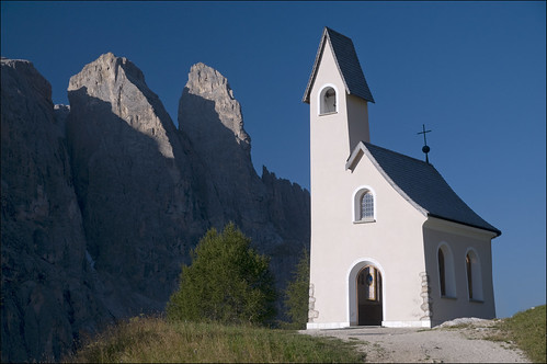
Gardena Pass S. Tyrol, Italy
The Gardena Pass (Italian: Passo Gardena; German: Grödnerjoch; Ladin: Ju de Frara or Jëuf de Frea) (el. 2136 m.) is a high mountain pass in South Tyrol in Italy. There are tourist accommodations on the pass itself. Walkers visit the pass to access the dramatic Dolomite mountains.
It connects Sëlva in the Val Gardena and Corvara in the Val Badia. The road over it comprises part of the famous Sella Ring, in which four linked passes (Gardena, Sella, Pordoi and Campolongo) encircle the spectacular Sella group. The route becomes busy with tourists, motorcyclists and cyclists during the summer.
It connects Sëlva in the Val Gardena and Corvara in the Val Badia. The road over it comprises part of the famous Sella Ring, in which four linked passes (Gardena, Sella, Pordoi and Campolongo) encircle the spectacular Sella group. The route becomes busy with tourists, motorcyclists and cyclists during the summer.
Sunday, September 4, 2011
Valparaiso Chile
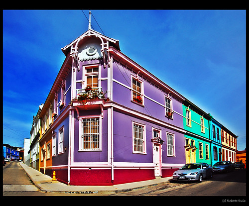
Valparaíso (/ˌvælpəˈraɪzoʊ/, Spanish: [balpaɾaˈiso]) is a city and commune of Chile, center of its third largest conurbation (Greater Valparaíso) and one of the country's most important seaports and an increasing cultural center in the Southwest Pacific hemisphere. The city is the capital of the Valparaíso Province and the Valparaíso Region. Although Santiago is Chile's official capital, the National Congress of Chile was established in Valparaíso in 1990.
Valparaíso played an important geopolitical role in the second half of the 19th century, when the city served as a major stopover for ships traveling between the Atlantic and Pacificoceans by crossing the Straits of Magellan. Always a magnet for European immigrants, Valparaíso mushroomed during its golden age, when the city was known by international sailors as “Little San Francisco” and “The Jewel of the Pacific.”
Examples of Valparaíso’s former glory include Latin America’s oldest stock exchange, the continent’s first volunteer fire department, Chile’s first public library, and the oldest Spanish language newspaper in continuous publication in the world. The opening of the Panama Canal and reduction in ship traffic dealt a staggering blow to Valparaíso, though the city has staged an impressive renaissance in recent years.
Though nearby San Antonio has taken the reins as the country’s most commercially important seaport (greater tonnage moved), the City of Valparaíso remains a vibrant center of Chilean culture, and the Greater Valparaíso metropolitan area (which includes Valparaíso, Viña del Mar, Quilpué and Villa Alemana) has the third largest concentration of population in the country after Greater Santiago and Greater Concepción.
"A journey of a thousand miles must begin with a single step." -- Lao Tzu Copyright © Demetrios the Traveler
Postcards from Belgium... another one from 'Brugge'?? | Flickr - Photo Sharing!
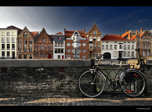
Bruges (Dutch: Brugge) is a town in Flanders, the northern part of Belgium. Relatively cosmopolitan and bourgeois given its compact size, it is one of the best preserved pre-motorised cities in Europe and offers the kind of charms rarely available elsewhere. Bruges is a postcard perfect stop on any tour of Europe.
The historical center is not so big and thus quite walkable. The only mode of public transport inside city is bus. Buses are operated by the Flemish public transport company De Lijn . Taxis on the market place and station cost about €10. Bicycles are easy to rent and make getting around the city very speedy, although the cobblestoned paths can make the rides a little bumpy and uncomfortable.
Some highlights: official site
- Groeninge Museum, Dijver 12, B-8000, [official site]. 7 days 9:30AM-5PM. Known as 'The city museum of Fine Arts', it houses a collection of artworks that span several centuries (14th-20th), focusing mainly on works by painters who lived and worked in Bruges. €8 / €6 (audioguide and ticket Arents House and Forum+ included in the entrance).
- Basilica of the Holy Blood (Heilige Bloed Basiliek), Burg 10, [official site]. Apr-Sep 9:30AM-11:50AM & 2PM-5:50PM, Oct-Mar 10AM-11:50AM & 2PM-3:50PM. A beautiful church on the Burg square. It houses a relic - a vial of blood that is said to be that of Jesus - and was built in the Gothic style. Try and get there early so you can view the chapel when it is quiet and not filled with tourists. And don't forget to visit the chapel underneath, in heavy Romanesque style - a contrast to the lovely light Gothic above. Free.
- Brewery De Halve Maan, Walplein 26, ☎ +31 50 332-697, [official site]. Apr-Oct M-Sa 11:00-16:00, Su 11:00-17:00. This brewery annex beer museum offers a tour of the beer making process. A history of the brewery is provided, as well as an overview of the city from its tower. The tour lasts for 45 minutes and is a good way to get a feel for Belgian beer making. The tours start at the exact turn of the hour, be at least fifteen minutes early as there is a maximum amount of people that can join. The entrance price includes one drink of Brugse Zot or Straffe Hendrik and is served after the tour at the outside terrace or indoor bar. €6 including 1 beer.
- Onze Lieve Vrouwkerk, Mariastraat. A fascinating church with architecture from the Romanesque and Gothic periods. In the east end of the church are very fine tombs of Charles the Bold and his daughter Mary of Burgundy - in contrasting Gothic and Renaissance styles, despite their superficial similarity. The church also houses one of the few Michelangelo sculptures outside of Italy, the "Madonna with child". Free.
- Jerusalem church, [official site]. In a quiet area of the city, a highly unusual church with octagonal tower built by the Adornes brothers, merchants of Italian extraction. It includes a fine black tournai marble tomb, late Gothic stained glass, and a tiny and rather spooky chapel containing an effigy of the dead Christ. The entrance fee also covers the Lace Museum in the former Adornes mansion, where you can see local women and girls learning this traditional craft.
- The Begijnhof. Also known as the convent, between the centre of the station and the city, with white painted small houses and fine plane trees, is a quiet place to walk - groups are discouraged.
- The Hospital of St John, [official site]. 09:30 - 17:00, Closed Mondays. Sint-Janshospitaal contains a museum of six paintings by Hans Memling, within the early medieval hospital buildings. €6 with Bruges card / €8.
- Choco-Story Museum, Wijnzakstraat 2 (Sint-Jansplein), ☎ 050/61.22.37, [official site]. 10AM-5PM. This museum is a must see for chocolate enthusiasts as it describes chocolate's transition from cocoa into chocolate. Its low cost tasty exhibits make it well worth the time (and Belcolade's gently overt marketing). Be sure to stay for the chocolate making exhibition to get some excellent samplers. €6 with Bruges card / €7.
- DiamantMuseum, Katelijnestraat 43, ☎ 050 33 63 26, [official site]. 10:30AM-5:30PM. Diamond museum has a large range of exhibits ranging from mining all the way to polishing and all the history in between. Everyday at 12:15 there is a live polishing demonstration. Individuals €6, Groups €4.5, Students €3.
- The Friet Museum, Vlamingstraat (opposite Academiestraat), [official site]. Check out the world's only frites (fries or chips) museum which tells the story of the humble potato from South America and how it has evolved into a fry. Don't forget to try the tastiest fries cooked by the guy who cooked for the Belgian Royal Family.
Bruges is visited by a huge number of tourists and it sometimes becomes quite annoying, especially around the Markt and Burg squares.
"A journey of a thousand miles must begin with a single step." -- Lao Tzu Copyright © Demetrios the Traveler
Saturday, September 3, 2011
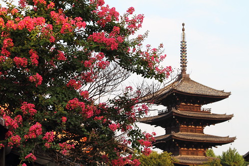
Pagoda of Yasaka in Higashiyama, Kyoto, Japan
Yasaka Shrine (八坂神社, Yasaka Jinja), also known as Gion Shrine, is one of the most famous shrines in Kyoto. Founded over 1350 years ago, the shrine is located between the popular Gion District and Higashiyama District, and is often visited by tourists walking between the two districts.
The shrine's main hall combines the honden (inner sanctuary) and haiden (offering hall) into a single building. In front of it stands a dance stage with hundreds of lanterns that get lit in the evenings. Each lantern bears the name of a local business in return for a donation.
Yasaka Shrine is well known for its summer festival, the Gion Matsuri, which is celebrated every July. Arguably the most famous festival in the whole country, the Gion Matsuri dates back over a thousand years and involves a procession with massive floats and hundreds of participants. The shrine also becomes busy during the cherry blossom season around early April, as the adjacent Maruyama Park is one of the most famous cherry blossom spots in Kyoto.
The shrine's main hall combines the honden (inner sanctuary) and haiden (offering hall) into a single building. In front of it stands a dance stage with hundreds of lanterns that get lit in the evenings. Each lantern bears the name of a local business in return for a donation.
Yasaka Shrine is well known for its summer festival, the Gion Matsuri, which is celebrated every July. Arguably the most famous festival in the whole country, the Gion Matsuri dates back over a thousand years and involves a procession with massive floats and hundreds of participants. The shrine also becomes busy during the cherry blossom season around early April, as the adjacent Maruyama Park is one of the most famous cherry blossom spots in Kyoto.
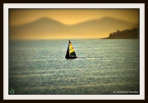
It's Always Summer
It's Always Summer
Heave the anchor short!
Raise main-sail and jib--steer forth,
O little white-hull'd sloop, now speed on really deep waters,
(I will not call it our concluding voyage,
But outset and sure entrance to the truest, best, maturest;)
Depart, depart from solid earth--no more returning to these shores,
Now on for aye our infinite free venture wending,
Spurning all yet tried ports, seas, hawsers, densities, gravitation,
Sail out for good, eidolon yacht of me!
by Walt Whitman
www.quotesandpoem.com/poems/SelectedPoemByTopic/Whitman/S...
Heave the anchor short!
Raise main-sail and jib--steer forth,
O little white-hull'd sloop, now speed on really deep waters,
(I will not call it our concluding voyage,
But outset and sure entrance to the truest, best, maturest;)
Depart, depart from solid earth--no more returning to these shores,
Now on for aye our infinite free venture wending,
Spurning all yet tried ports, seas, hawsers, densities, gravitation,
Sail out for good, eidolon yacht of me!
by Walt Whitman
www.quotesandpoem.com/poems/SelectedPoemByTopic/Whitman/S...
Friday, September 2, 2011
Mount Rushmore South Dakota USA
![last sighting, mount rushmore [L1008246]](http://farm7.static.flickr.com/6207/6104961055_c2e24cac96.jpg)
Mount Rushmore National Memorial is a sculpture carved into the granite face of Mount Rushmore near Keystone, South Dakota, in the United States. Sculpted by Gutzon Borglumand later by his son Lincoln Borglum, Mount Rushmore features 60-foot (18 m) sculptures of the heads of former United States presidents (in order from left to right) George Washington,Thomas Jefferson, Theodore Roosevelt and Abraham Lincoln. The entire memorial covers 1,278.45 acres (5.17 km2) and is 5,725 feet (1,745 m) above sea level.
South Dakota historian Doane Robinson is credited with conceiving the idea of carving the likenesses of famous people into the Black Hills region of South Dakota in order to promote tourism in the region. Robinson's initial idea was to sculpt the Needles; however, Gutzon Borglum rejected the Needles site and chose the larger Mount Rushmore. Borglum also decided the sculpture should have a more national focus, and chose the four presidents whose likenesses would be carved into the mountain. After securing federal funding, construction on the memorial began in 1927, and the presidents' faces were completed between 1934 and 1939. Upon Gutzon Borglum's death in March 1941, his son Lincoln Borglum took over construction. Although the initial concept called for each president to be depicted from head to waist, lack of funding forced construction to end in October 1941.
The U.S. National Park Service took control of the memorial in 1933, while it was still under construction, and manages the memorial to the present day. It attracts approximately two million people annually.
"A journey of a thousand miles must begin with a single step." -- Lao Tzu Copyright © Demetrios the Traveler
Thursday, September 1, 2011
Badshahi Masjid, Lahore, Pakistan

The Badshahi Mosque (Urdu: بادشاھی مسجد) or the 'King's Mosque' in Lahore, commissioned by the sixth Mughal Emperor Aurangzeb in 1671 and completed in 1673, is the second largest mosque in Pakistan and South Asia and the fifth largest mosque in the world. Epitomising the beauty, passion and grandeur of the Mughal era, it is Lahore's most famous landmark and a major tourist attraction.
Capable of accommodating 5,000 worshippers in its main prayer hall and a further 95,000 in its courtyard and porticoes, it remained the largest mosque in the world from 1673 to 1986 (a period of 313 years), when overtaken in size by the completion of the Faisal Mosque in Islamabad. Today, it remains the second largest mosque in Pakistan and South Asia and the fifth largest mosque in the world after the Masjid al-Haram (Grand Mosque) of Mecca, the Al-Masjid al-Nabawi (Prophet's Mosque) in Medina, the Hassan II Mosque in Casablanca and the Faisal Mosque in Islamabad.
To appreciate its large size, the four minarets of the Badshahi Mosque are 13.9 ft (4.2 m) taller than those of the Taj Mahal and the main platform of the Taj Mahal can fit inside the 278,784 sq ft (25,899.9 m2) courtyard of the Badshahi Mosque, which is the largest mosque courtyard in the world.
In 1993, the Government of Pakistan recommended the inclusion of the Badshahi Mosque as a World Heritage Site in UNESCO's World Heritage List, where it has been included in Pakistan's Tentative List for possible nomination to the World Heritage List by UNESCO.
"A journey of a thousand miles must begin with a single step." -- Lao Tzu Copyright © Demetrios the Traveler
Subscribe to:
Posts (Atom)
