Wednesday, December 28, 2011

visit #greece Infographic 2011


ΘΕΜΑ: Στοιχεία και αριθμοί για το 2011:
To VisitGreece.gr και η συνεχόμενα ανοδική πορεία του στο χώρο των μέσων κοινωνικής δικτύωσης
Από τις αρχές του 2010, το www.visitgreece.gr, το επίσημο site προβολής της χώρας μας ως τουριστικός, και όχι μόνο, προορισμός, διαγράφει μια επιτυχημένη πορεία στο χώρο των μέσων κοινωνικής δικτύωσης, με σημαντική παρουσία σε FacebookYouTube και Flickr
Το φθινόπωρο του 2010, προστίθεται στη λίστα των καναλιών προβολής μας και το Twitter.
Από το φθινόπωρο του 2011, επεκτείνουμε τη δραστηριότητά του αυτή στο Foursquare - που δίνει τη δυνατότητα στο χρήστη να εξερευνήσει την Ελλάδα, κάνοντας check in σε εκπληκτικά μέρη και προορισμούς - αλλά και στο Google+, μέσα από το οποίο μπορεί να μοιραστεί φωτογραφίες, βίντεο, συμβουλές αλλά και χρήσιμες πληροφορίες που φωτίζουν τις μοναδικές ομορφιές της χώρας μας.
 Μέσα σε σύντομο σχετικά χρονικό διάστημα και έπειτα από μια αξιοσημείωτη, ανοδική πορεία, καταφέραμε να χτίσουμε μια αμφίδρομη, διαδραστική σχέση με το κοινό, να αναπτύξουμε μια προσωπική επαφή με κάθε επισκέπτη ξεχωριστά, αλλά και να δημιουργήσουμε μια χρηστική πλατφόρμα επικοινωνίας, προσιτή στους δυνητικούς επισκέπτες.
 Για αυτό, φιλοδοξία του Visit Greece είναι να διευρύνει ακόμα περισσότερο τον κύκλο των ανθρώπων που αγαπούν την Ελλάδα και αγκαλιάζουν τη δράση του επίσημου site του Ελληνικού Οργανισμού Τουρισμού, όπως επαγγελματίες ταξιδιωτικοί συντάκτες, travel bloggers αλλά και Έλληνες πολίτες, που με τη σειρά τους θα λειτουργήσουν ως πρεσβευτές της προσπάθειας για την προώθηση της χώρας μας ως μοναδικό τόπο εμπειριών, για κάθε εποχή του χρόνου.
Στην προσπάθεια αυτή λοιπόν, είναι αναγκαίο να συμβάλουμε όλοι, κάθε Έλληνας και κάθε Ελληνίδα. Να αγκαλιάσουμε το επίσημο site μας και τα κανάλια προβολής μας σε όλα τα κοινωνικά μέσα. 
Σας καλούμε να ισχυροποιήσετε την παρουσία του www.visitgreece.gr, κάνοντας followlike+1, και να διαδώσετε το μήνυμα για την προβολή της χώρας μας παντού.
 Στο infographic που θα βρείτε συνημμένο θα έχετε την ευκαιρία να δείτε αναλυτικά την πορεία του www.visitgreece.gr στα μέσα κοινωνικής δικτύωσης για το 2011, αλλά και το περιεχόμενο, τα posts, tweets, photos, videos και tips που αγαπήθηκαν περισσότερο από όλο τον κόσμο που μας παρακολουθεί.
Από Γραφείο Επικοινωνίας
Ελληνικού Οργανισμού Τουρισμού


Infographic 2011, originally uploaded by Visit Greece.

Wednesday, December 21, 2011

December 22 is a Solstice Day in 2011

Media_httpwwwtimeandd_rkdwg

The December solstice occurs when the sun reaches its most southerly declination of -23.5 degrees. In other words, it is when the North Pole is tilted 23.5 degrees away from the sun. Depending on the Gregorian calendar, the December solstice occurs annually on a day between December 20 and December 23. On this date, all places above a latitude of 66.5 degrees north (Arctic Polar Circle) are now in darkness, while locations below a latitude of 66.5 degrees south (Antarctic Polar Circle) receive 24 hours of daylight.

Use the Sunrise and Sunset calculator to calculate the number of daylight hours in many cities worldwide during the December solstice.

The sun is directly overhead on the Tropic of Capricorn in the southern hemisphere during the December solstice. It also marks the longest day of the year in terms of daylight hours for those living south of the equator. Those living or travelling south from the Antarctic Circle towards the South Pole will see the midnight sun during this time of the year.

On the contrary, for an observer in the northern hemisphere, the December solstice marks the day of the year with the least hours of daylight. Those living or traveling north of the Arctic Circle towards the North Pole will not be able to see the sun during this time of the year.

more : via timeanddate.com


Friday, December 9, 2011

Holiday Traveling in Europe [infographic]

So Brits like to holiday in Europe more often than in Texas.

That’s okay with me, the most sought after destination for the British, Spain, is quite the location. The majority of people I know who’ve studied abroad went to Spain and I’ve heard it is a wonderful place.

Although, the mix of balconies, sangria and an inexcusable butchery of the Spanish language tends to lead to the ER for some chaps. Spain takes cake with nearly double of the amount of hospitalizations for UK tourists than any other country in Europe.

The only reason I can think is that they party too hard. France has almost 10 million visits a year from the United Kingdom, but only 217 medical emergencies come out of them. Come on France, Step up! Why would I want to go on a vacation where I’m promised safety, security and a scar-free visit? I wouldn’t. Spain sounds much more exciting and I believe that’s why the British tend to vacation there. 

Media_httpdailyinfogr_qjfhh


Thursday, December 8, 2011

Δήμος Καρπενησίου ... αξέχαστα Χριστούγεννα


377901_233661060037718_187518281318663_559653_1133223347_n


Ο Δήμος Καρπενησίου παρουσιάζει το πρόγραμμα των εκδηλώσεων των Γιορτών Χειμώνα που θα κρατήσουν συντροφιά στους δημότες αλλά και τους επισκέπτες μας καθ'όλη τη διάρκεια των χριστουγεννιάτικων εορτών.

Την παράσταση κλέβει το παγοδρόμιο αλλά και το Βασίλειο των Πάγων που θα στηθούν στην κεντρική πλατεία της πόλης μας...

Σας περιμένουμε όλους για να περάσουμε ανεπανάληπτες στιγμές!


Sunday, November 20, 2011

Greenland Dock , London UK

photo via Roman Gerodimos

Greenland Dock is the oldest of London's riverside wet docks, located in Rotherhithe in the area of the city now known as Docklands. It used to be part of the Surrey Commercial Docks, most of which have by now been filled in. Greenland Dock is now used purely for recreational purposes; it is one of only two functioning enclosed docks on the south bank of the River Thames.


The dock was originally laid out between 1695-99 on land owned by the aristocratic Russell family of the 1st Duke of Bedford. The Russells had been given a portion of land in lower Rotherhithe by a wealthy Streatham landowner, John Howland, as part of a wedding dowry for his daughter Elizabeth, granddaughter of Sir Josiah Child - the dictatorial chairman of the East India Company, who married Wrothesley Russell, the Marquis of Tavistock. They immediately set about "improving" the rural property, obtaining parliamentary permission in 1695 to construct a rectangular dock with an area of about 10 acres (4.0 ha), capable of accommodating around 120 ships. It was named Howland Great Wet Dock in honour of John Howland. Designed by local shipwright, John Wells, the dock was intended to refit East India ships.


more info via Wikipedia


"A journey of a thousand miles must begin with a single step." -- Lao Tzu Copyright © Demetrios the Traveler

Thursday, November 17, 2011

SUGAR LOAF , Rio de Janeiro, Brasil

Sugarloaf Mountain (in Portuguese, Pão de Açúcar), is a peak situated in Rio de Janeiro, Brazil, at the mouth of Guanabara Bay on a peninsula that sticks out into the Atlantic Ocean. Rising 396 metres (1,299 ft) above the harbor, its name is said to refer to its resemblance to the traditional shape of concentrated refined loaf sugar.

Sunday, November 6, 2011

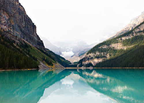
Lake Louise, Albrta Canada


Lake Louise, originally uploaded by mahonyweb.

Lake Louise is a hamlet in Alberta, Canada within Improvement District No. 9 Banff (Banff National Park). It is named for the nearby Lake Louise, which in turn was named after the Princess Louise Caroline Alberta (1848–1939), the fourth daughter of Queen Victoria, and the wife of John Campbell, the 9th Duke of Argyll, who was the Governor General of Canada from 1878 to 1883. The province of Alberta is also named for Princess Louise.

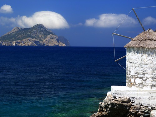
Cycladic scenery Aegean Sea Grece


Cycladic scenery, originally uploaded by Marite2007.

Windmill, cliff and Aegean sea. Aegiali, Amorgos island, Cyclades, Greece

Friday, October 28, 2011

Matera's Heart of Stone | Flickr - Photo Sharing!

Media_httpfarm7static_zpfsr
Basilicata - Italy Matera has gained international fame for its ancient town, the "Sassi di Matera" (meaning "stones of Matera"). The Sassi originate from a prehistoric (troglodyte) settlement, and are suspected to be some of the first human settlements in Italy. The Sassi are houses dug into the calcareous rock itself, which is characteristic of Basilicata and Apulia. Many of these "houses" are really only caverns, and the streets in some parts of the Sassi often are located on the rooftops of other houses. The ancient town grew in height on one slope of the ravine created by a river that is now a small stream. The ravine is known locally as "la Gravina". In the 1950s, the government of Italy forcefully relocated most of the population of the Sassi to areas of the developing modern city. However, people continued to live in the Sassi, and according to the English Fodor's guide: “ Matera is the only place in the world where people can boast to be still living in the same houses of their ancestors of 9,000 years ago. ” Until the late 1980s this was considered an area of poverty, since these houses were, and in most areas still are, mostly unlivable. Current local administration, however, has become more tourism-oriented, and has promoted the re-generation of the Sassi with the aid of the European Union, the government, UNESCO, and Hollywood. Today there are many thriving businesses, pubs, and hotels. en.wikipedia.org/wiki/Matera

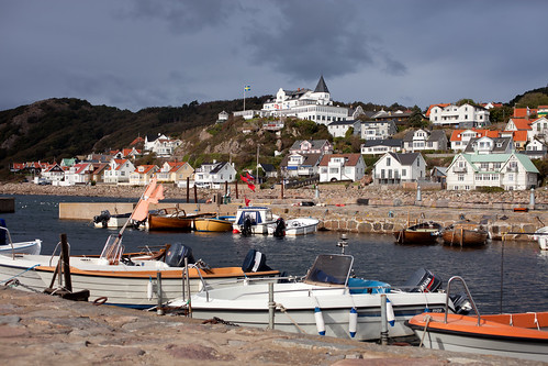
Mölle by the sea, Höganäs, Skåne, Sweden


Mölle by the sea, originally uploaded by Håkan Dahlström.

Mölle is a locality situated in Höganäs Municipality, Skåne County, Sweden with 725 inhabitants in 2005.
It is best known for its scenic harbour and its location adjacent to the Kullaberg Nature Reserve. Its harbour, situated on the Kattegat Strait, provides services for marine fishing, watersports outings and tour excursions along the coast, especially the rocky shore of Kullaberg to the north. Fodor characterizes Mölle as "a small town set in spectacular isolation on the dramatic headland of the Kulla Peninsula".
As a historic seaside resort, Mölle has hosted numerous technical and professional conferences such as: the Swedish Network of European Economists, Joint Swedish-Russian International Workshop on Information Theory; and the Royal Society (United Kingdom) of Tropical Medicine and Hygiene.

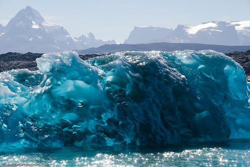
Hypnotic Iceberg


Hypnotic Iceberg, originally uploaded by Marc Shandro.

Another view of the same iceberg I posted a while ago showing more of the surrounding context in Lake Argentina in Los Glaciares National Park. This iceberg is about 4m (12ft) high above the water.

Tuesday, October 25, 2011

Sahara Wondrland

 "A journey of a thousand miles must begin with a single step." -- Lao Tzu Copyright © Demetrios the Traveler

Monday, October 24, 2011

Crete from Space, Aegean Sea, Greece


The Aegean and Libyan Seas in the eastern Mediterranean are split by the island of Crete, which is seen in prominence in this Envisat image.
The image is a collation of three separate passes by the European Space Agency’s Envisat satellite on 11 December 2010, 10 January and 11 March 2011. Each pass was assigned a separate colour – red, green and then blue – and the changes in colour reveal changes in the surface between the three passes.
At the top of the image is the southern portion of the Cyclades island group, including the islands of Milos, Ios, Anafi and Santorini.

Thursday, October 20, 2011

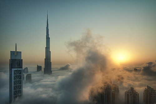
Foggy sunrise in Dubai, UAE


Foggy sunrise in Dubai #1, originally uploaded by momentaryawe.com.

Dubai has a rich collection of buildings and structures of various architectural styles. Many modern interpretations of Islamic architecture can be found here, due to a boom in construction and architectural innovation in the Arab World in general, and in Dubai in particular, supported not only by top Arab or international architectural and engineering design firms such as Al Hashemi and Aedas, but also by top firms of New York and Chicago.[96] As a result of this boom, modern Islamic – and world – architecture has literally been taken to new levels in skyscraper building design and technology. Dubai now boasts more completed or topped-out skyscrapers higher than 2/3 km, 1/3 km, or 1/4 km than any other city. A culmination point was reached in 2010 with the completion of the Burj Khalifa (Khalifa Tower), now by far the world's tallest building at 828 m (2,717 ft). The Burj Khalifa's design is derived from the patterning systems embodied in Islamic architecture, with the triple-lobed footprint of the building based on an abstracted version of the desert flower hymenocallis which is native to the Dubai region. The completion of the Khalifa Tower, following the construction boom that began in the 1980s, accelerated in the 1990s, and took on a rapid pace of construction unparalled in modern human history during the decade of the 2000s, leaving Dubai with the world's tallest skyline as of 4 January 2010

Midnight Sun @ #Iceland

Midnight Sun: A natural phenomenon occurring in the summer months north of the Arctic Circle and south of the Antarctic Circle where the sun never fully sets and remains visible 24 hours a day. This short time lapse film was shot during the Icelandic Midnight Sun in June of 2011. For 17 days I travelled solo around the entire island shooting almost 24 hours, sleeping in the car, and eating whenever I had the time. During my days shooting this film I shot 38,000 images, travelled some 2900 miles, and saw some of the most amazing, beautiful, and indescribable landscapes on the planet. Iceland is absolutely one of the most beautiful and unusual places you could ever imagine. Especially during the Midnight Sun when the quality of light hitting the landscape is very unusual, and very spectacular. Iceland is a landscape photographers paradise and playground, and should be number 1 on every photographers must visit list. Iceland during the Midnight Sun is in sort of a permanent state of sunset. The sun never full sets and travels horizontally across the horizon throughout the night, as can be seen in the opening shot and at the :51 second mark in the video. During the Arctic summer, sunset was at midnight and sunrise was at 3am. The Arctic summer sun provided 24 hours a day of light, with as much as 6 hours daily of "Golden light". Once the sun had set it wouldn't even get dark enough for the stars to come out, and they don't start to reappear until August.  "A journey of a thousand miles must begin with a single step." -- Lao Tzu Copyright © Demetrios the Traveler

Tuesday, October 18, 2011

Hopper Gilgit Pakistan


Rush Lake 4694m.., originally uploaded by M Atif Saeed.
Rush Lake 4694m..

The Hunza-Nagar Valley, the Hunza-Nagar District, is the seventh district of Gilgit-Baltistan of Pakistan. The district comprises Hunza and Nagar. Sikandarabad is the administrative center of this district. Before the announcement of new district, Hunza-Nagar was part of district Gilgit.

Monday, October 17, 2011

How to Stay Healthy When Traveling


Nothing ruins a holiday more than getting sick. While some illnesses are largely unpreventable, being aware of the risks and taking a few precautions before you go can make all the difference. Here are a few basic tips for staying healthy on the road.
Photo by: Gustey.com

Before you go

Research your destination. Are you traveling to a yellow fever zone? Is there a high risk of an infectious disease? Will you be at risk of altitude sickness? The best source of information on traveler’s health is the Centers for Disease Control (CDC) website. If you are still not sure, visit your local doctor. Make sure you do your research several weeks before your leave date as you may require a course of vaccinations. Also, if you’ve been putting off that trip to the dentist, now may be a good time to go!

Packing

A basic first-aid kit is a must. Essentials include band-aids, antiseptic wipes, iodine/antiseptic cream, painkillers, insect repellent, sun cream and any prescription drugs you may be using. You may also want to consider bandages, water purifying tablets, anti-malarials, anti-diarrheal, vitamins and oral hydration sachets. The more health risks your destination and activities pose, the bigger your first aid kit should be!

On the Road

Get lots of rest!
Get lots of rest!
Before you freak out, cancel your plane ticket and refuse to leave the house, take heart, there are a few easy ways of staying healthy while you’re away.
  • Plan your itinerary to give yourself time to adjust to a new place and recover from jet lag. This particularly applies if you are traveling to a high altitude!
  • Be aware of how a change in climate may affect your particular health condition and plan accordingly
  • Make sure you have enough of your own prescription medication to last your trip and pack it in your hand luggage. Keep it in its original packaging to avoid delays at the airport
  • Pack as lightly as possible and be careful when lifting your luggage
  • Be aware of the dangers of the sun – take a hat and high-factor sun cream
  • Stay hydrated. If local water poses a risk, drink bottled water and don’t have drinks with ice
  • Trust your instinct when eating at stalls or restaurants – if they look dodgy they probably are.  It may be prudent to avoid meat and rice if eating at dodgy restaurant is unavoidable!
  • Strengthen your immune system: eat healthily, get enough sleep and exercise
  • Clean cuts well
  • Wash your hands when possible
  • Avoid mosquito prone areas if you can. Cover up, use repellent and a mosquito net when sleeping
  • If bitten by an animal, wash wound well with soap and water and seek medical advice immediately.
  • Take a rain jacket
  • Practice safe sex
  • Get health insurance!
Hope these tips help you stay safe and healthy on your next trip!
Emma McMahon


"Ποταμοῖς τοῖς αὐτοῖς ἐμβαίνομέν τε καὶ οὐκ ἐμβαίνομεν, εἶμέν τε καὶ οὐκ εἶμεν.""We both step and do not step in the same rivers. We are and are not."Heraclitus the Riddler

Prague, Czech Republic

Dear Praha  by Edgar Barany (EdgarBarany)) on 500px.com
Dear Praha by Edgar Barany

Prague is the capital and largest city of the Czech Republic. Situated in the north-west of the country on the Vltava river, the city is home to about 1.3 million people, while its metropolitan area is estimated to have a population of over 2.3 million. The city has a temperate oceanic climate with warm summers and chilly winters.
Prague has been a political, cultural and economic centre of Europe and particularly central Europe during its 1,100 year existence. For centuries, during theGothic and Renaissance eras, Prague was the permanent seat of two Holy Roman Emperors and thus was also the capital of the Holy Roman Empire. Later it was an important city in the Habsburg Monarchy and the Austro-Hungarian Empire, and after World War I became the capital of Czechoslovakia. The city played major roles in theProtestant Reformation, the Thirty Years' War, and in 20th-century history, during both World Wars and the post-war Communist era.
Prague is home to a number of famous cultural attractions, many of which survived the violence and destruction of twentieth century Europe. Main attractions include the following: Prague Castle, the Charles BridgeOld Town Square, the Jewish Quarter, the Lennon Wall, and Petřín hill. Since 1992, the extensive historic centre of Prague has been included in the UNESCOlist of World Heritage Sites.
Prague boasts more than ten major museums, along with countless theatres, galleries, cinemas, and other historical exhibits. Also, Prague is home to a wide range of public and private schools, including the famous Charles University. Its rich history makes it a popular tourist destination, and the city receives more than 4.1 million international visitors annually, as of 2009. Prague is classified as a global city.

more via Wikipedia

"A journey of a thousand miles must begin with a single step." -- Lao Tzu Copyright © Demetrios the Traveler

Sunday, October 16, 2011

Colmar, Alsace, France

Colmar is the third largest city in Alsace and a Jewelry box. You can see a lot of colorful very well-preserved half-timbered houses. Here "La petite Venise" with the Lauch river.

Colmar, die drittgrösste Stadt im Elsass, zeigt sich mit bunt bemalten, sehr gut erhaltenen Fachwerkhäusern von seiner besten Seite. Hier seht ihr das Schmuckkästchen, das Viertel Klein Venedig, am Fluss Lauch.

Colmar (French: Colmar, Alsatian: Colmer, German: Colmar, between 1940-1945 under Nazi rule: Kolmar) is a commune in the Haut-Rhin department in Alsace in north-eastern France. It is the capital of the department. Colmar is also the seat of the highest jurisdiction in Alsace, the appellate court. It is situated along the Alsatian Wine Route and considers itself to be the "Capital of Alsatian Wine" (capitale des vins d'Alsace). In 2006, the city of Colmar had a population of 65,713 and the metropolitan area of Colmar had a population of 120,367. Colmar is the center of the arrondissement of Colmar, which has 144,700 inhabitants in 2006.
Colmar is the home town of the painter and engraver Martin Schongauer and the sculptor Frédéric Bartholdi, who designed the Statue of Liberty. The city is renowned for its well preserved old town, its numerous architectural landmarks and its museums, among which the Unterlinden Museum.
Colmar was founded in the 9th century. This was the location where Charles the Fat held a diet in 884. Colmar was granted the status of a free imperial city of the Holy Roman Empire in 1226. During the Thirty Years' War, the city was taken by the armies of Sweden in 1632, who held it for two years. The city was conquered by France under Louis XIV in 1697.
In 1679 (Treaties of Nijmegen) Colmar was ceded to France. With the rest of Alsace, Colmar was annexed by the newly formed German Empire in 1871 as a result of the Franco-Prussian War. It returned to France after World War I, was annexed by Nazi Germany in 1940, and then reverted to French control after the battle of the "Colmar Pocket" in 1945.
The Colmar Treasure, hidden during the Black Death, was discovered here in 1863.

Colmar is 64 kilometres (40 mi) south-southwest of Strasbourg, on the Lauch River, directly to the east of the Vosges Mountains. It is connected to the Rhine by a canal.

Mostly spared by the destructions of the French Revolution and the wars of 1870-1871, 1914-1918 and 1939-1945, the cityscape of old-town Colmar is homogenous and renowned among tourists. The area crossed by canals of the river Lauch, and which formerly served as the butcher's, tanner's and fishmonger's quarter, is now called "little Venice" (la Petite Venise). Colmar's cityscape (and neighbouring Riquewihr's) served for the design of the Japanese animated film Howl's Moving Castle. (Source: Wikipedia)

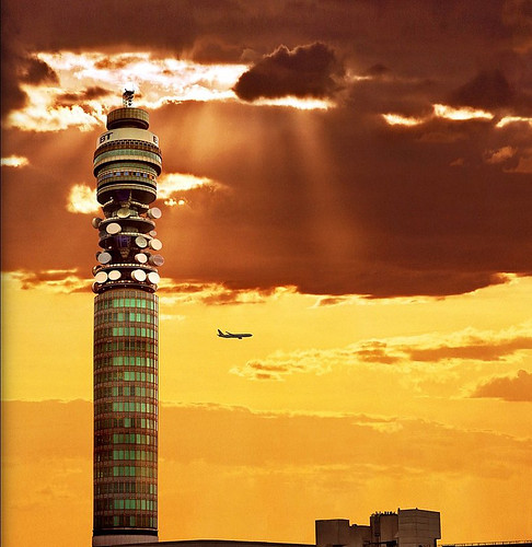
London UK


Keep, originally uploaded by Katarina 2353.

London is the largest urban area and the capital of England and the United Kingdom. An important settlement for two millennia, London's history goes back to its founding by the Romans. Since its settlement, London has been part of many important movements and phenomena throughout history, such as the English Renaissance, the Industrial Revolution, and the Gothic Revival. The city's core, the ancient City of London, still retains its limited medieval boundaries; but since at least the 19th century the name "London" has also referred to the whole metropolis which has developed around it. Today the bulk of this conurbation forms the London region of England and the Greater London administrative area, with its own elected mayor and assembly.

London is one of the world's leading business, financial, and cultural centres, and its influence in politics, education, entertainment, media, fashion and the arts all contribute to its status as a major global city. London boasts four World Heritage Sites: The Palace of Westminster, Westminster Abbey and St. Margaret's Church; the Tower of London; the historic settlement of Greenwich; and the Royal Botanic Gardens, Kew. The city is one of the most popular tourist destinations in the world, and its popularity has increased over the years due to economic growth.

London's diverse population draws from a wide range of peoples, cultures, and religions, and over 300 languages are spoken within the city. As of 2006, it has an official population of 7,512,400 within the boundaries of Greater London and is the most populous municipality in the European Union. As of 2001, the Greater London Urban Area has a population of 8,278,251 and the metropolitan area is estimated to have a total population of between 12 and 14 million. London will be hosting the 2012 Summer Olympics.

en.wikipedia.org/wiki/London

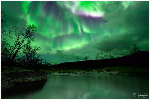
Norwegian Woods


Norwegian Woods, originally uploaded by Ole C. Salomonsen.

Amazing conditions currently from the flow from the sun. Barely time to be home.

Just have to charge the batteries and head out again!

I crawled out on a narrow slippery rock to be able to shoot this. Low standpoint, as low as my tripod allwoed me.

The river was very very calm, I could look straight through the surface to the bottom when the lights lit it up in the complete darkness.

Wednesday, October 12, 2011

Abandoned Casino Constanta Romania


Abandoned Casino, originally uploaded by Bogdan Suditu.


Constanța (Romanian pronunciation: [konˈstant͡sa]; historical names: TomisGreekΚωνστάντια, KonstantiaBulgarianКюстенджа, KyustendzhaTurkishKöstence) is the oldest extant city inRomania, founded around 600 BC. The city is located in the Dobruja region of Romania, on the Black Sea coast. It is the capital of Constanța County and the largest city in the region.
The city of Constanța is one of the most important in Romania, one of four roughly equal-size cities which rank after Bucharest. The Constanța metropolitan area, founded in 2007, comprises 14 localities located at a maximum distance of 30 km (19 mi) from the city, and with 446,595 inhabitants it is the second largest metropolitan area in Romania, after Bucharest.
The Port of Constanța has an area of 39.26 km2 (15.16 sq mi) and a length of about 30 km (19 mi). It is the largest port on the Black Sea, and one of the largest ports in Europe.

Friday, September 30, 2011

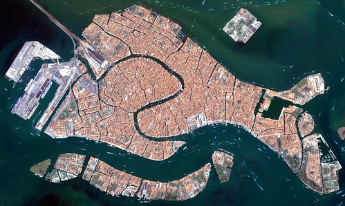
Venice Italy from space.. a Floating city


Earth From Space: Floating city, originally uploaded by europeanspaceagency.


The islands that make up the Italian city of Venice and the surrounding Venetian Lagoon are pictured in this image. Snaking through the central districts is the Grand Canal, with the Santa Lucia train station at its northern end and the Saint Mark Basin at its southern end. Zooming in, we can see water buses and taxis navigating the canal and gondolas docked along the edge. The square island to the north is San Michele. Once a prison island, it became a cemetery when Napoleon’s occupying forces declared burial on the main islands unsanitary.
This image was acquired on 22 June 2008 by Ikonos-2, a commercial satellite that provides panchromatic and multispectral high-resolution imagery. ESA is supporting Ikonos-2 as a Third Party Mission, which means that the Agency uses its multi-mission European ground infrastructure and expertise to acquire, process and distribute data from the satellite to its wide scientific user community.
High resolution versions of this image can be found at: www.esa.int/esaEO/SEM44R0UDSG_index_1.html

Monday, September 26, 2011

Château de Chantilly France

The Château de Chantilly (pronounced: [ʃɑ.to də ʃɑ̃.ti.ji]) is a historic château located in the town of Chantilly, France. It comprises two attached buildings; the Grand Château, destroyed during the French Revolution and rebuilt in the 1870s, and the Petit Château which was built around 1560 for Anne de Montmorency. Owned by the Institut de France, the château houses the Musée Condé, which is one of the finest art galleries in France and is open to the public.

Saturday, September 24, 2011

St. Kilda, Scotland, UK


St Kilda (Scottish Gaelic: Hiort) is an isolated archipelago 64 kilometres (40 mi) west-northwest of North Uist in the North Atlantic Ocean. It contains the westernmost islands of the Outer Hebrides of Scotland. The largest island is Hirta, whose sea cliffs are the highest in the United Kingdom. The islands are administratively a part of the Comhairle nan Eilean Siar local authority area.
St Kilda was permanently inhabited for at least two millennia, with its population probably never exceeding 180 (and certainly no more than 100 after 1851). The entire population was evacuated from Hirta (the only inhabited island) in 1930. Currently, the only year-round residents are defence personnel although a variety of conservation workers, volunteers and scientists spend time there in the summer months.
The origin of the name St Kilda is a matter of conjecture. The islands' human heritage includes numerous unique architectural features from the historic and prehistoric periods, although the earliest written records of island life date from the Late Middle Ages. The medieval village on Hirta was rebuilt in the 19th century, but the influences of religious zeal, illnesses brought by increased external contacts through tourism, and the First World War all contributed to the island's evacuation in 1930. The story of St Kilda has attracted artistic interpretations, including an opera.
The entire archipelago is owned by the National Trust for Scotland. It became one of Scotland's five World Heritage Sites in 1986 and is one of the few in the world to hold joint status for its natural and cultural qualities. Two different early sheep types have survived on these remote islands, the Soay, a Neolithic type, and the Boreray, an Iron Age type. The islands are a breeding ground for many important seabird species including Northern Gannets, Atlantic Puffins, and Northern Fulmars. The St Kilda Wren and St Kilda Field Mouse are endemic subspecies. Parties of volunteers work on the islands in the summer to restore the many ruined buildings that the native St Kildans left behind. They share the island with a small military base established in 1957.

readers

labels and tags

Powered By Blogger