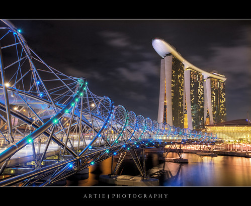
Sunday, July 31, 2011

The DNA of Marina Bay Sands Singapore

The Helix Bridge , previously known as the Double Helix Bridge , is a pedestrian bridge linking Marina Centre with Marina South in the Marina Bay area in Singapore. It was officially opened on 24 April 2010 at 9 pm, however only half was opened due to ongoing construction at the Marina Bay Sands. It is located beside the Benjamin Sheares Bridge and is accompanied by a vehicular bridge, known as the Bayfront Bridge. The entire bridge was opened on 18 July 2010 to complete the entire walkway around Marina Bay.
The bridge complements other major development projects planned in the area, including the highly-anticipated Integrated Resort Marina Bay Sands, Singapore Flyer, Gardens by the Bay and the 438,000 m² business and financial centre which will be ready by 2012.

Saturday, July 30, 2011

Milos, Greece


Milos, Greece, originally uploaded by Matteo Melchior.

Milos (in Greek, Μήλος, classic Greek: Μῆλος – Melos, Doric Greek: Μάλος – Malos), is a volcanic Greek island in the Aegean Sea, just north of the Sea of Crete. Milos is the southwesternmost island in the Cyclades group.
The island is famous for the statue of Aphrodite (the "Venus de Milo", now in the Louvre), and also for statues of the Greek god Asclepius (now in the British Museum) and the Poseidon and an archaic Apollo in Athens. The Municipality of Milos also includes the uninhabited offshore islands of Antimilos and Akradies. The combined land area is 160.147 km² and the 2001 census population was 4,771 inhabitants.
via Wikipedia. http://en.wikipedia.org/wiki/Milos

Thursday, July 28, 2011

The Grand Theatre Ephesus, Turkey


The Grand Theatre 1, originally uploaded by Son of Groucho.
Ephesus (Ancient Greek Ἔφεσος, Ephesos; Turkish Efes) was an ancient Greek city, and later a major Roman city, on the west coast of Asia Minor, near present-day Selçuk, Izmir Province, Turkey. It was one of the twelve cities of the Ionian League during the Classical Greek era. In the Roman period, it was for many years the second largest city of the Roman Empire; ranking behind Rome, the empire's capital.[1][2] Ephesus had a population of more than 250,000 in the 1st century BC, which also made it the second largest city in the world.[2]
The city was famed for the Temple of Artemis (completed around 550 BC), one of the Seven Wonders of the Ancient World. The temple was destroyed in 401 AD by a mob led by St. John Chrysostom.[3] Emperor Constantine I rebuilt much of the city and erected new public baths. The town was again partially destroyed by an earthquake in 614 AD. The city's importance as a commercial center declined as the harbor was slowly silted up by the Cayster River (Küçük Menderes).
Ephesus was one of the seven churches of Asia that are cited in the Book of Revelation.[4] The Gospel of John may have been written here.[5] The city was the site of several 5th century Christian Councils, see Council of Ephesus. It is also the site of a large gladiators' graveyard.
Today's archaeological site lies 3 kilometers southwest of the town of Selçuk, in the Selçuk district of İzmir Province, Turkey. The ruins of Ephesus are a favorite international and local tourist attraction, partly owing to their easy access from Adnan Menderes Airport and via the port of Kuşadası.

{EAV_BLOG_VER:449cf8c121c84f68}

Corsica, France


Corsica (play /ˈkɔːrsɪkə/; French: Corse, IPA: [kɔʁs]; Corsican: Corsica; Italian: Corsica, IPA: [ˈkɔrsika]) is an island in the Mediterranean Sea. It is located west of Italy, southeast of the Frenchmainland, and north of the island of Sardinia.
Corsica is one of the 27 régions of France, although strictly speaking Corsica is designated as a "territorial collectivity" (collectivité territoriale) by law. As a territorial collectivity, it enjoys greater powers than other French régions, but for the most part its status is quite similar. Corsica is referred to as a "région" in common speech, and is almost always listed among the other régions of France. Although the island is separated from the continental mainland by the Ligurian Sea and is closer to Italy than to the French mainland, politically Corsica is part of Metropolitan France. It was once briefly an independent Corsican Republic, until being incorporated into France in 1769. Its culture has both French and Italian elements.
Napoléon Bonaparte was born in Ajaccio, where his ancestral home, Casa Buonaparte, is also located. Corsica is also the birthplace of the singers Tino Rossi and Alizée.
via Wikipedia

Corsica : arrival in Bastia

Corsica - Summer 07 - 02

Corsica - Summer 07 - 03

Corsica sampler


"A journey of a thousand miles must begin with a single step." -- Lao Tzu Copyright © Demetrios the Traveler

Kalkara Creek, Malta


Kalkara Creek, originally uploaded by albireo2006.

Kalkara is a small town in Malta, with a current population of 2,856 (Dec 2009). The name comes from the Latin word for lime (Calce), as there was a lime kiln present there since Roman times. Kalkara forms part of the inner harbour area and although not geographically part of Cottonera, as the three cities of Birgu, Isla and Bormla are known, it is unofficially included in this grouping due to its close proximity.

Wednesday, July 27, 2011

Isa Bey Mosque, Turkey


Isa Bey Mosque, originally uploaded by Son of Groucho.

The İsabey Mosque (Turkish: İsabey Camii), constructed in 1374-1375, is one of the oldest and most impressive works of architectural art remaining from the Anatolian beyliks. The mosque is situated between the Saint Jean Church and the remains of the Temple of Artemis on the skirts of the Ayasluğ Hills at Selçuk, İzmir, formerly Ephesus in Turkey. It was built by the architect Şamlı Dımışklıoğlu Ali in honor of the Aydınoğlu İsa Bey. In the 19th century, it was also used as a caravanserai.
The mosque has two main entrances, to the east and to the west. The western wall has inscriptions and geometric shapes engraved. These walls are covered with marble, whereas the façades on the remaining sides are made of cut stone. It is built asymmetrically on a 48 m by 56 m (157 by 184 ft) base. The rims of its domes (of diameters of 9.4 m and 8.1 m) are decorated with İznik (Nicaea) tiles. 12 round columns stand inside its courtyard encircled with porches. Its brick minaret is built on an octagonal base, and the upper part from the balcony is ruined. The mosque had another minaret on the west, which is totally destroyed now. The mihrab (niche or altar) was moved to another mosque, due to a door opened there. There is an octagonal Seljuk türbe made of stone and bricks, with a pyramid shaped roof, right next to the mosque.

en.wikipedia.org/wiki/%C4%B0sa_Bey_Mosque

Monday, July 25, 2011

Slavonice, Moravia, Czech Republic


Slavonice, originally uploaded by istanbulnorthend.

Slavonice (Czech pronunciation: [ˈslavoɲɪtsɛ]; German: Zlabings) is a town situated in the southwest of Moravia on the border with South Bohemia, Czech Republic, about a kilometre from the Austrian border with about 2,700 inhabitants. While historically the town was in Moravia the town now belongs to the South Bohemian Region.
The town has a traditional medieval renaissance city centre with Sgraffito covered buildings dating from the 14th to 16th centuries, the oldest dating to 1545. The Sgraffito are the second oldest in the Czech Republic, with older existing only in Prague from 1544. The renaissance character of the town is due to a period of extreme wealth in the 14th to 16th century when Slavonice were an important town on the route from Prague to Vienna. When the route was relocated to the north, passing through Znojmo the town's source of wealth dried up as the local farming and forestry activities could never generate enough income. The town is therefore very much preserved in its renaissance look.
The town and the surrounding countryside were lightly fortified in the period leading up to the Second World War. Some of these small bunker řopík complexes have been repaired and refurbished, with mock battles of Wehrmacht and Czechoslovak forces taking place in summer. The area and defences were never used against the Third Reich as the town and region had to be surrendered to the Third Reich following the Munich Agreement.
The original German-speaking population was expelled in June 1945 following the Second World War.
Being so close to the Austrian border, Slavonice was heavily affected by the creation of the Iron Curtain during the period of Communism. The nearby hamlet of Maříž was emptied of its inhabitants during the Communist era in an effort to prevent people from living anywhere near the border with non-Communist Austria (the current inhabitants could stay but no new residents could move in and property could not be sold or inherited).
After the Velvet Revolution and the fall of Communism, Maříž was recolonized by ceramics artists, and Slavonice has once again become a popular destination for Czech tourists and artists. Many small galleries have sprung up as a result of the work of artists and workshops in Slavonice.
Slavonice is very popular not only for its preserved renaissance town centre but also for the underground tunnel system dating back to the 12th century and surrounding countryside, which is unspoiled by industry.
The region is popular with cyclists who can take advantage of a large area known as Czech Canada Česká Kanada, an area that was inaccessible under communism but that now offers a pleasant ride through pine and spruce forests on narrow border-patrol roads where there is very limited car traffic.
The town applied for UNESCO World Heritage protection seeking to become a partner to the nearby UNESCO protected Telč but withdrew its application before a decision was reached.

Infographic: The Social Travel Revolution

Infographic-the-social-travel-revolution-hi-res

Social media can shape the way that we make our decisions on a day-to-day basis and this is seen very much in the travel industry. This great infographic from Swedish social travel startup Tripl demonstrates how interactions through social media are effecting this industry.

A few key points of interest for me are:

  • 72% of all social network users access their social network sites daily while they are travelling
  • 200 million passengers will board GOGO-WIFI flights this year
  • 69% of all travel companies saw traffic growth from Facebook
  • 46% of all travel companies saw traffic growth from Twitter
  • The top 5 airlines have 2,566,000 fans on Facebook
  • 50 million trip reviews have been created for TripAdvisor

This infographic gathers data from major players in the social media field, as well as large travel and data sites like Quantcast.com and TripAdvisor.com

Piscine de Roubaix, Lille, France


Piscine de Roubaix, originally uploaded by .Choco..

In the last few years of the twentieth century the Mayor of Lille in northern France had a quandary. The old swimming pool in the small town of Roubaix had been closed in 1985 due to safety problems.

So, why not simply knock the old building down? What was the problem?

The swimming pool just happened to be a stunningly beautiful example of Art Deco architecture. Time for a peculiarly French solution.
The swimming pool was turned in to a museum. Originally built between 1927 and 1932 by the architect Albert Baert, the swimming pool had served the people of Roubaix for over fifty years and the Roubaisiens, rightly, were very fond of their pool. Yet the health and safety issues meant that it could no longer be used for that purpose. Thinking laterally, why not make it in to a museum?
The problem had been with the vault under the pool. After fifty years of supporting the enormous weight of a pool full of water it was estimated that it would probably collapse if it continued to be used as a pool.If there were bathers in the pool at the moment of collapse that might possibly present an issue for the local council.
So, the repair work was undertaken and ten years ago in October a vast crowd attended the re-opening of La Piscine as it is called. The first year exceeded all expectations. Around 80,000 visitors were anticipated but the museum (the La Piscine-Musée d'Art et d'Industrie André Diligent to give the place its proper name) drew over two hundred thousand.

Sunday, July 24, 2011

Tribute to the Space Shuttle from the European astronauts

Venice - Rio di San Barnaba - Dorsoduro

Dorsoduro includes the highest land areas of the city and also Giudecca island and Isola Sacca Fisola. Its name derives from the Italian for "hard ridge", due to its comparatively high, stable land.
The original heart of the area was the Giudecca Canal, along which building were constructed from the sixth century[citation needed]. By the eleventh century, settlement had spread across to the Grand Canal, while later religious buildings including the Basilica of Santa Maria della Salute and the Zattere quay are now its main landmarks.
In the nineteenth century the Accademia was set up in Dorsoduro and the Ponte dell'Accademia linked it to San Marco, making it an expensive area popular with foreign residents. The western quarter, end and the Giudecca, became industrialised around this time.
Attractions on the main islands include the Peggy Guggenheim Collection, the Palazzo Dario, San Trovaso, San Pantalon, San Nicolò da Tolentino, the Ospedale Giustinian, the Church of San Sebastiano, the Palazzo Ariani, the Palazzo Zenobio, the Church of Santa Maria del Carmelo and Scuola Grande dei Carmini, Campo Santa Margherita, Ca' Foscari, Ca' Rezzonico and Campo San Barnaba.

via wikipedia

Danube above the town of Melk, Austria

Melk (older spelling: Mölk) is a city of Austria, in the federal state of Lower Austria, next to the Wachau valley along the Danube. Melk has a population of 5,222 (as of 2001).
The town is first mentioned as Medilica in 831 in a donation of Louis the German; the name is from a Slavic word for 'border.'
The area around Melk was given to Margrave Leopold I in the year 976 to serve as a buffer between the Magyars (called "Turks" in that time's sources) to east and Bavaria to the west. In 996 mention was first made of an area known as Ostarichi, which is the origin of the word Oesterreich (German for Austria). The bluff which holds the current monastery held a Babenberger castle until the site was given to Benedictine monks from nearby Lambach by Margrave Leopold II in 1089. Melk received market rights in 1227 and became a municipality in 1898. In a very small area, Melk presents a great deal of architectural variety from many centuries.

via wikipedia

Thursday, July 21, 2011

Alpe di Siusi, Alto Adige,Italia

Seiser Alm, (Italian: Alpe di Siusi) is the largest high altitude Alpine meadow in Europe. Located in Italy's South Tyrol province in the Dolomites mountain range, it is a major tourist attraction, known for skiing and hiking.

via Wikipedia

Wednesday, July 20, 2011

Most Beautiful Greek Beach 2011


"A journey of a thousand miles must begin with a single step." -- Lao Tzu Copyright © Demetrios the Traveler

Tuesday, July 19, 2011

Aστυπαλιά


Aστυπαλιά, originally uploaded by Christina Aroni.

Astypalaia (Greek: Αστυπάλαια, pronounced [astiˈpalea]) is a Greek island with 1,238 residents (2001 census). It belongs to the Dodecanese, an island group of twelve major islands in the southeastern Aegean Sea. The Island is 18 km. long, 13 km. wide at the most, and covers an area of 97 km2. Along with numerous smaller uninhabited offshore islets (the largest of which are Sýrna and Ofidoussa), it forms the Municipality of Astypalaia. Astypalaia is part of the Kalymnos peripheral unit.
The coasts of Astypalaia are rocky with many small pebble-strewn beaches. A small band of land of roughly 10 kilometres, almost separates the island in two sections. The capital and the previous main harbour of the island is Astypalaia or Chora, as it is called by the locals. A new harbour has been buildt in Agios Andreas on the mid island from where now the connections are west and east with Piraeus and the other islands of the Dodecanese. Flight connections with Athens from the airport close to Maltezana. The island has also been called in Italian: Stampalia; Ottoman Turkish: استانبوليه İstanbulya.
via Wikipedia

Sunday, July 17, 2011

Richmond London


Richmond London, originally uploaded by doug88888.

Richmond is a town in southwest London, England and is part of the London Borough of Richmond upon Thames. It is located 8.2 miles (13.2 km) west-southwest of Charing Cross. The formation and naming of the town are due to the building of Richmond Palace early in the 16th century. The development of Richmond as a London suburb began with the opening of the railway station in 1846. It was formerly part of the ancient parish of Kingston upon Thames in the county of Surrey and it became a municipal borough in 1890 that was enlarged in 1892 and 1933. It has formed part of Greater London since 1965. Located on a meander of the River Thames, Richmond now forms a significant local commercial centre with a number of parks and open spaces and has a developed retail and night-time economy.

Brisbane, Australia

Brisbane ( /ˈbrɪzbən/), is the capital and most populous city in the Australian state of Queensland and the third most populous city in Australia. Brisbane's metropolitan area has a population of over 2 million and constitutes the core of the South East Queensland agglomeration, encompassing more than 3 million people. The Brisbane central business district stands on the original European settlement and is situated inside a bend of the Brisbane River approximately 23 kilometres from its mouth at Moreton Bay. The metropolitan area extends in all directions along the floodplain of the Brisbane River valley between the bay and the Great Dividing Range. While the metropolitan area is governed by several municipalities, a large proportion of central Brisbane is governed by the Brisbane City Council which is Australia's largest Local Government Area by population.
Brisbane is named after the river on which it sits which, in turn, was named after Sir Thomas Brisbane, the Governor of New South Wales from 1821 to 1825. The first European settlement in Queensland was a penal colony at Redcliffe, 28 kilometres (17 mi) north of the Brisbane central business district, in 1824. That settlement was soon abandoned and moved to North Quay in 1825. Free settlers were permitted from 1842. Brisbane was chosen as the capital when Queensland was proclaimed a separate colony from New South Wales in 1859.
The city played a central role in the Allied campaign during World War II as the South West Pacific headquarters for General Douglas MacArthur. Brisbane has hosted many large cultural and sporting events including the 1982 Commonwealth Games, World Expo '88 and the final Goodwill Games in 2001. Brisbane is the largest economy between Sydney and Singapore and in 2008 it was classified as a gamma world city+ in the World Cities Study Group’s inventory by Loughborough University. It was also rated the 16th most livable city in the world in 2009 by The Economist.


via Wikipedia http://en.wikipedia.org/wiki/Brisbane

Saturday, July 16, 2011

Laikipia Plateau, Kenya


Roving Elephants, originally uploaded by Abercrombie&Kent.

The eastern escarpment of the Rift Valley known as the Laikipia Plateau, is divided into a patchwork of enormous ranches. Over the years with cooperation from their owners, these farms were transformed into game reserves and now contain some of the most exclusive lodges in the remotest parts of Kenya.

Laikipia Wildlife Forum was founded and an enormous wildlife stronghold was born. The Forum hopes that Laikipia will increasingly be seen as Kenya's foremost exclusive destination due to the select nature of its lodges, the important ecosystem with large wildlife populations, and the fact that the plateau is home to more endangered species than anywhere else in East Africa.
The area is extremely scenic with the escarpment giving way to dramatic wooded gorges and tangled riverine thickets. It has been made famous by Kuki Gallman who wrote 'I Dreamed of Africa' about her life in this secluded part of Africa. It is an area unknown to package tourists because all the accommodation is on private land where you are treated more like a house guest than a tourist.

Natural Sand Sculptures, Farafra, Egypt.


Natural Sand Sculptures, originally uploaded by Abercrombie&Kent.

The Farafra depression (Arabic: واحة الفرافرة‎) is the second biggest depression by size located in Western Egypt and the smallest by population, near latitude 27.06° North and longitude 27.97° East. It is located in the Western Desert of Egypt, approximately mid-way between Dakhla and Bahariya.
Farafra has an estimated 5,000 inhabitants (2002) mainly living in the town of Farafra (Arabic: مدينة الفرافرة‎) and is mostly inhabited by the local Bedouins. Parts of the town have complete quarters of traditional architecture, simple, smooth, unadorned, all in mud colour. Local pride has also secured endeavours to secure local culture. Also located near Farafra are the hot springs at Bir Sitta and the El-Mufid lake.
A main geographic attraction of Farafra is its White Desert (known as Sahara el Beyda, with the word sahara meaning a desert). The White Desert of Egypt is located 45 km (30 miles) north of the town of Farafra. The desert has a white, cream color and has massive chalk rock formations that have been created as a result of occasional sandstorm in the area. The Farafra desert is a typical place visited by some schools in Egypt, as a location for camping trips. The Desert was also the featured location in the music video for "Echoes" by the Klaxons.

Guel Parc, Barcelona, spain.


Guel Parc, Barcelona, originally uploaded by BENID.

Park Güell (Catalan: Parc Güell, IPA: [ˈparg ˈɡweʎ]) is a garden complex with architectural elements situated on the hill of el Carmel in the Gràcia district of Barcelona, Catalonia, Spain. It was designed by the Catalan architect Antoni Gaudí and built in the years 1900 to 1914. It is part of the UNESCO World Heritage Site "Works of Antoni Gaudí".

Scituate Lighthouse, Massachusetts, USA


Scituate Lighthouse, originally uploaded by renzodionigi.

Members of the Plymouth Colony, along with newcomers from England, settled the area we now know as Scituate, on Boston's South Shore, in 1627. Its name comes from an Indian word for "cold brook," and refers to a brook that runs into the harbor. The town developed a significant fishing industry by the late eighteenth century, owing to its small but protected harbor, sheltered by Cedar Point to the north and First Cliff to the south. Entering the harbor was difficult because of shallow water and mud flats.

Local citizens petitioned the town's selectmen for a lighthouse in 1807. The selectmen convinced the federal government to appropriate $4,000 in 1810 for the building of a lighthouse at the harbor entrance at Cedar Point. Three men from the nearby town of Hingham built the lighthouse, finishing it in September 1811, two months ahead of schedule. The 25-foot-tall stone tower was accompanied by a one-and-a-half-story keeper's house, an oil vault, and a well.

Friday, July 15, 2011

Durdle Door & Bat's Head, Lulworth. Dorset, UK


Durdle Door & Bat's Head, originally uploaded by Mukumbura.

Durdle Door is a natural limestone arch on the Jurassic Coast near Lulworth in Dorset, England. It is privately owned by the Welds, a family who own 12,000 acres (50 km2) in Dorset in the name of the Lulworth Estate. It is open to the public. The name Durdle is derived from an Old English word 'thirl' meaning bore or drill.
The arch has formed on a concordant coastline where bands of rock run parallel to the shoreline. Here the rock strata are nearly vertical, and the bands of rock are quite narrow. Originally a band of resistant Portland limestone ran along the shore, the same band which can be seen one mile down the coast forming the narrow entrance to Lulworth Cove. Behind this is a 400-foot (120 m) band of weaker rocks which are easily eroded, and behind this is a stronger and much thicker band of chalk, which forms the Purbeck Hills. The limestone and chalk are much closer together here than at Swanage, 10 miles (16 km) to the east, where the distance between them is over 2 miles (3 km). There are at least three reasons for this. First, the beds are highly inclined here, and more gently angled at Swanage. Secondly, some of the beds have been cut out by faulting at Durdle Door; and thirdly, the area around Durdle Door appears to have been unusually shallow, so a much thinner sequence of sediments were deposited here. At Durdle Bay all except a short stretch of the limestone has been completely eroded away by the sea and the remainder forms a small headland where it has protected the clay behind. At the western end this band of limestone has been eroded through, creating the natural arch. Some teams at UNESCO have been working on saving both the arch and the beach which resides by it.
The 400-foot (120 m) isthmus which joins the limestone to the chalk is made of a 50-metre (160 ft) band of Portland limestone, which is less resistant than the Purbeck beds, a narrow and compressed band of Cretaceous clays—Wealden Clay, sands and chert beds—and then narrow bands of Greensand and sandstone. In Man of War Bay, the small bay immediately east of Durdle Door the Portland stone has not been entirely eroded away, and at low tide the band of Portland stone is partially revealed.

Wednesday, July 13, 2011

Old Town in Poznań, Poland


Old Town in Poznań, Poland, originally uploaded by ami.photos.

Poznań [ˈpɔznaɲ] ( listen) (Latin: Posnania; German: Posen; Yiddish: פוזנא or פּױזן Poyzn) is a city on the Warta river in west-central Poland, with a population of 556,022 in June 2009. It is among the oldest cities in Poland, and was one of the most important centres in the early Polish state, whose first rulers were buried at Poznań's cathedral. It is sometimes claimed to be the first capital of the kingdom of Poland.
Poznań is now Poland's fifth largest city. It is the historical capital of the Wielkopolska ("Greater Poland") region, and is currently the administrative capital of the province called Greater Poland Voivodeship.
Poznań is an important centre of trade, industry, and education, and hosts regular international trade fairs. It was the host city for the United Nations Climate Change Conference in December 2008, a key stage in the creation of a successor to the Kyoto Protocol. Poznań was a candidate city for European Capital of Culture in 2016.

Haroué - France


Haroué - France, originally uploaded by MorBCN.

The château de Craon, also known as the château d'Haroué or palais d'Haroué is a French château located in a small valley in the centre of the village of Haroué, in the Saintois, in the département of Meurthe-et-Moselle and the région of Lorraine. It was built between 1720 and 1732 by Germain Boffrand during the period when Lorraine was independent of France, for Marc de Beauvau, prince de Craon, viceroy of Tuscany and constable of Lorraine.
Surprisingly, the architect had to integrate into his plans the four towers and moat of an older medieval château, a consideration for medieval buildings which was unusual for the classicist period. Le château's design also symbolises a year :
365 windows,
52 fireplaces,
12 towers (several included in the buildings),
4 bridges crossing the moat.
The decoration was largely entrusted to artists from Lorraine : Jean Lamour (1698–1771) for the gates, balconies and staircases, Pillement (1698–1771) for the painted decoartion of one of the towers, Barthélemy Guibal (1699–1757), sculptor of the fountains of place Stanislas at Nancy, for the statuary. The park "à la française" was designed by Emilio Terry.
It has since been lived in by the descendants of prince Marc.
The château was classified as a monument historique in 1983.

Monday, July 11, 2011

Coogee, Randwick, New South Wales, Australia


Coogee Pool, originally uploaded by -yury-.

Coogee is a beachside suburb of local government area City of Randwick. It is located 8 kilometres south-east of the Sydney central business district, in the state of New South Wales, Australia. It is also a part of the Eastern Suburbs of Sydney.
The Tasman Sea and Coogee Bay along with Coogee Beach lie towards the eastern side of the suburb. The beach is popular for swimming. The boundaries of Coogee are formed mainly by Clovelly Road, Carrington Road and Rainbow Street, with arbitrary lines drawn to join these thoroughfares to the coast in the north-east and south-east corners.

Saturday, July 9, 2011

Phi Phi Ley Island, Thailand


Phi Phi Ley Island, originally uploaded by Jim Boud.

The Phi Phi Islands (Thai: หมู่เกาะพีพี, Thai pronunciation: [pʰīː pʰīː]) are located in Thailand, between the large island of Phuket and the western Andaman Sea coast of the mainland. The islands are administratively part of Krabi province. Ko Phi Phi Don ("ko" (Thai: เกาะ) meaning "island" in the Thai language) is the largest island of the group, and is the only island with permanent inhabitants, although the beaches of the second largest island, Ko Phi Phi Lee (or "Ko Phi Phi Leh"), are visited by many people as well. The rest of the islands in the group, including Bida Nok, Bida Noi, and Bamboo Island (Ko Mai Phai), are not much more than large limestone rocks jutting out of the sea.
Phi Phi Don was initially populated by Muslim fishermen during the late 1940s, and later became a coconut plantation. The Thai population of Phi Phi Don remains more than 80% Muslim. The actual population however, if counting laborers, especially from the north-east, from the mainland is much more Buddhist these days.
The islands came to worldwide prominence when Ko Phi Phi Leh was used as a location for the 2000 British-American film The Beach. This attracted criticism, with claims that the film company had damaged the island's environment, an accusation the film's makers contest. The film's release was attributed to an increase in tourism to the islands. Phi Phi Leh also houses the 'Viking Cave', from which there is a thriving bird's nest soup industry.
Ko Phi Phi was devastated by the Indian Ocean Tsunami of December 2004, when nearly all of the island's infrastructure was destroyed. As of 2010 most, but not all, of this has been restored.

New Orleans Louisiana USA

New Orleans Balconies
New Orleans ( /njuː ˈɔrliənz/ or /ˈnjuː ɔrˈliːnz/, locally /nuː ˈɔrlənz/ or /ˈnɔrlənz/; French: La Nouvelle-Orléans [la nuvɛlɔʁleɑ̃] ( listen)) is a major United States port and the largest city and metropolitan area in the state of Louisiana. The New Orleans metropolitan area, (New Orleans–Metairie–Kenner) has a population of 1,235,650 as of 2009, the 46th largest in the USA. The New Orleans – Metairie – Bogalusa combined statistical area has a population of 1,360,436 as of 2000. The city/parish alone has a population of 343,829 as of 2010.

Lighthouse, Rethymno harbour, Crete, Greece


Early morning at the harbour, originally uploaded by Theophilos.

Rethymno (Greek: Ρέθυμνο, [ˈreθimno], also Rethimno, Rethymnon, Réthymnon, and Rhíthymnos) is a city of approximately 40,000 people in Greece, the capital of Rethymno peripheral unit in the island of Crete. It was built in antiquity (ancient Rhithymna and Arsinoe), even though was never a competitive Minoan center. It was, however, strong enough to mint its own coins and maintain urban growth. One of these coins is today depicted as the crest of the town with two dolphins in a circle.
This region as a whole is rich with ancient history, most notably through the Minoan civilisation centred at Kydonia east of Rethymno.

Rethymno itself began a period of growth when the Venetian conquerors of the island decided to put an intermediate commercial station between Heraklion and Chania, acquiring its own bishop and nobility in the process. Today's old town (palia poli) is almost entirely built by the Venetians. It is one of the best preserved old towns in Crete.
The town still maintains its old aristocratic appearance, with its buildings dating from the 16th century, arched doorways, stone staircases, Byzantine and Hellenic-Roman remains, the small Venetian harbor and narrow streets. The Venetian Loggia today houses the information office of the Ministry of Culture. A Wine Festival is held there annually at the beginning of July. Another festival is held on 7-8 November, in memory of the destruction of the Arkadi Monastery.
The city's Venetian-era citadel, the Fortezza, is one of the best-preserved castles in Crete. Other monuments include the Neratze mosque (the Municipal Odeon arts centre), the Great Gate (Μεγάλη Πόρτα, Porta Guora), the Piazza Rimondi (Rimondi square) and the Venetian Loggia.
The town was also captured by the Ottoman Turks in 1646 and was ruled by them for almost three centuries. The town (Resmo in Turkish) was the centre of a sanjak during Ottoman rule.
During the Battle of Crete, the Battle of Rethymno was fought between German Paratroopers and Australian and Greek forces. Although initially unsuccessful, the Germans won the battle after receiving reinforcements from Maleme.
Today the city's main income is from tourism, many new facilities having been built in the past 20 years. Agriculture is also notable, especially for olive oil and other Mediterranean products. It is also the base of the Philosophical School and the University Library of the University of Crete and the School of Social and Political Sciences having 8000 students on its University Campus per annum at "Galos", where the Academic Institute of Mediterranean Studies is situated. The city has an Archaeological Museum and a Historical and Folklore Museum.

Kennedy Space Center, Orlando Florida USA


"A journey of a thousand miles must begin with a single step." -- Lao Tzu Copyright © Demetrios the Traveler

Inspired by Iceland


Inspired by Iceland Video from Inspired By Iceland on Vimeo.
www.inspiredbyiceland.com


Iceland is more alive than ever, bursting with energy, activity and hospitality.

Take a look for yourself - click and be inspired by Iceland!


"A journey of a thousand miles must begin with a single step." -- Lao Tzu Copyright © Demetrios the Traveler

Thursday, July 7, 2011

Königssee, St. Bartholomä pier, Bavaria, Germany-Austria.


Summertime in St. Bartholomä, originally uploaded by B℮n.

The Königssee is a lake located in the extreme southeast of the German state of Bavaria, near the border with Austria. It's all part of the Berchtesgaden National Park. Located at a Jurassic rift it was formed by glaciers during the last ice age. It stretches about 7.7 km. The lake similar to a fjord is surrounded by steeply rising flanks of mountains up to 2700 m. The lake is noted for its clear water and is advertised as the cleanest lake in Germany. For this reason, only electric driven passenger ships, rowing and pedal boats have been permitted on the lake since 1909. Due to its picturesque setting, the lake and surrounding parklands are very popular with tourists and hikers. In addition, the lake's position surrounded by sheer rock walls creates an echo, which is known for its clarity. St. Bartholomä, a famous pilgrimage church with a small inn nearby, is located on a peninsula about halfway down the western lakeshore. It named for Saint Bartholomew the Apostle Bartholomäus in German. A first chapel at the lake was built in 1134 from 1697 onwards it has been rebuilt in a Baroque style with a floor plan modelled on Salzburg Cathedral, two onion domes and a red domed roof. St. Bartholomä and the southern edge can only be reached by boat or via hiking trails up the surrounding mountains.

"Mirror, mirror on the wall, what lake's the fairest of them all?" Lake Königssee is what most of our visitors would answer. Hardly surprising, with its crystal-clear emerald-green water and mystifying atmosphere. Innumerable fish swim its depths and its surface reflects the rocky walls of the Watzmann massif. Photo taken the pier at St. Bartholomä.

Lace Batur, Kedisan, Bali, Indonesia


Good morning Kedisan, originally uploaded by tropicaLiving.

Kedisan is a small rural village on the edge of Lake Batur, under the shadow of the magnificent active volcano Mt Batur. The village's income is predominantly farming and the view as you drive down to Kedisan is a magnificent patchwork of the many different crops. There you can find a small floating restaurant and bungalows which offers such romantic hide out place :) ( See more on their website )

Lake Batur itself is the largest lake overshadowed by the active volcano Mount Batur, at the northeast of Bali. Batur Lake is the widest lake in this island. The lake is classified as a "neutral-dilute" lake because there is no known underlying hydrothermal activity, and the abundant rainfall more than quenches any such activity.
There is a hot spring right by the lake. We can enjoy the spectacular "shimmers sheet of blue glass" scenery of Batur Lake from Kintamani. Across the lake, only reachable by boat, lies Trunyan village, where the Bali Aga people live.
The surrounding of the lake is a favorite place for picks self up.
At Batur Lake we can see the scenic view and feel cool atmosphere, all surrounded by the high walls of the crater rim and colorful sulfuric rocks. The place is a great day trips, trekking or just to get away from the daily activity.

Normandie, Rouen, France...

Le Gros Horloge (the Great Clock) is the main medieval symbol of Rouen (France).
The clock is located on a beautiful stone arch which crosses the Rue du Gros Horloge, the famous street in Rouen with beautiful half-timbered houses of the 15, 16 and 17th centuries.
In 1409; a clock face was installed on the archway over a gate in the ancient Roman walls.
The current archway and clock faces, were rebuilt between 1527-1529.
The giant astronomical renaissance clock indicates the hour, day of the week and the phase of the moon.
Rouen is the historic capital city of Normandy, in northern France on the River Seine.
Rouen was one of the largest and most prosperous cities of medieval Europe.
It was in Rouen where Joan of Arc was burnt in 1431.
Rouen is also known for its Notre Dame Cathedral (built from the 12th century).

Thailand Cliché


Thailand Cliché, originally uploaded by Jim Boud.

If you've ever looked at photos of Thailand, chances are you've seen one similar to this. I know this is such a typical shot, but I had to take it nevertheless! This was taken at Maya Bay on Phi Phi Ley island. Apparently this is where the movie "The Beach" with Leonardo Dicaprio was filmed (I've never seen the movie). Although this place is beautiful, it's become a big tourist attraction and was very crowded...I was lucky to get a shot off with no people or speedboats spoiling the view.

Monday, July 4, 2011

Gibraltar


Gibraltar, originally uploaded by Eivind's phone.

Gibraltar ( /dʒɨˈbrɔːltər/) is a British overseas territory located on the southern end of the Iberian Peninsula at the entrance of the Mediterranean. A peninsula with an area of 6.843 square kilometres (2.642 sq mi), it has a northern border with Andalusia, Spain. The Rock of Gibraltar is the major landmark of the region. At its foot is the densely populated city area, home to almost 30,000 Gibraltarians and other nationalities.
An Anglo-Dutch force captured Gibraltar in 1704 during the War of the Spanish Succession. The territory was subsequently ceded to Britain by Spain "in perpetuity" under the Treaty of Utrecht in 1713. It was an important base for the British Royal Navy; today its economy is based largely on tourism, financial services, and shipping.
The sovereignty of Gibraltar is a major point of contention in Anglo-Spanish relations as Spain asserts a claim to the territory. Gibraltarians resoundingly rejected proposals for Spanish sovereignty in referenda held in 1967 and 2002. Under its 2006 constitution Gibraltar governs its own affairs, though some powers, such as defence and foreign relations, remain the responsibility of the UK Government.

readers

labels and tags

Powered By Blogger