Showing posts with label S.AMERICA. Show all posts

Wednesday, May 12, 2010

Sunday, March 21, 2010

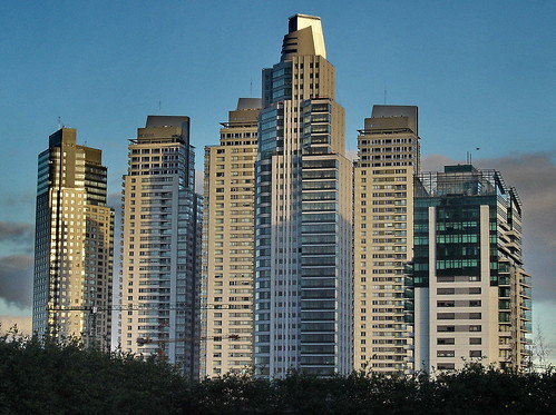
Buenos Aires, Argentina

Buenos Aires is the capital and largest city of Argentina, currently the second-largest metropolitan area in South America, after São Paulo. It is located on the western shore of the estuary of the Río de la Plata, on the southeastern coast of the South American continent. The city of Buenos Aires is not part of Buenos Aires Province, nor is it its capital; rather, it is an autonomous federal district. Greater Buenos Aires is the third-largest conurbation in Latin America, with a population of around 13 million. Buenos Aires is considered an Alpha World City listed by the Loughborough University group's (GaWC) 2008 inventory.
After the internal conflicts of the 19th century, Buenos Aires was federalised and removed from Buenos Aires Province in 1880. The city limits were enlarged to include the former towns of Belgrano and Flores, which are both now neighbourhoods of the city.
Buenos Aires (English: Fair Winds or Good Air (see Names of Buenos Aires)) was originally named after the sanctuary of "Nostra Signora di Bonaria" (Italian for "Our Lady of Bonaria") in Cagliari, Sardinia. In the 1994 constitution the city became autonomous, hence its formal name: Ciudad Autónoma de Buenos Aires, in English, Autonomous City of Buenos Aires. People from Buenos Aires are referred to as porteños (people of the port).

"A journey of a thousand miles must begin with a single step." -- Lao Tzu
Copyright © Demetrios the Traveler


Thursday, September 10, 2009

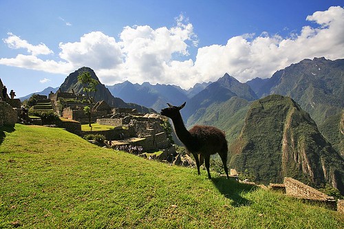
Machu Picchu


Machu Picchu, originally uploaded by maksid.

Φθινοπωρινή Ισημερία έτος 1130 Νότια Αμερική, κορδιλιέρα των Άνδεων.

Ο Ίνκα Μάνκο Ρουπάκ, τέταρτος της Δυναστείας των Μάνκο Κάπακ ενηλικιώνεται…εβδομάδες ολόκληρες, ταξιδεύει, σκαστός από τη πρωτεύουσα του πατερά του, να πάει να βεβαιωθεί αν είναι αλήθεια ο θρύλος…τα ασημένια νερά της Τιτικακα προβάλλουν πίσω από την πλάγια…πρέπει να φτάσει πριν χαράξει…πρέπει να περάσει την λίμνη βράδυ…ο ντόπιος βαρκάρης τον περνά απέναντι, αφού παίρνει το χρυσό βραχιόλι που φορά…να κι όχθη…μόλις πατεί το πόδι του στη στεριά διατάζει τον βαρκάρη να τον περιμένει…απομακρύνεται κατ εκεί που θα βγει ο ήλιος….τα μάτια του προσπαθούν να σκίσουν το λυκαυγές…ανεβαίνει…αρχίζει να φέγγει, κάθεται ανακούρκουδα και περιμένει…η πρώτη ηλιαχτίδα βγαίνει από το πανύψηλο Ιλλιμάνι απέναντι, φωτίζει ακριβώς το κέντρο του οροπεδίου που απλώνεται στα πόδια του…φωτίζει ακριβώς την βάση της Πύλης του Ήλιου που είχαν στήσει τα πανάρχαια χρόνια οι προγονοί του οι Τιουανακο…είναι Φθινοπωρινή ισημερία….έγινε άντρας…στο θερινό ηλιοστάσιο θα γινόταν βασιλιάς….


"A journey of a thousand miles must begin with a single step." -- Lao Tzu
Copyright © Demetrios the Traveler


Digg!


Wednesday, July 15, 2009

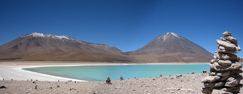
Atakama desert, Chile


Atakama desert, originally uploaded by robmcm.
Lakes in the Atakama desert


The Atacama Desert is a virtually rainless plateau in South America, covering a 966 km (600 mi) strip of land on the Pacific coast of South America, west of the Andes mountains.
The Atacama desert is, according to NASA, National Geographic and many other publications, the driest desert in the world. The rain shadow on the leeward side of the Chilean Coast Range and the Andes, as well as a coastal inversion layer created by the cold offshore Humboldt Current, keep this over 20 million-year-old desert 50 times drier than California's Death Valley.
The Atacama occupies 181,300 square kilometers (70,000 mi²) in northern Chile, composed mostly of salt basins (salares), sand, and lava.


The Atacama is one of the driest places on Earth, and is virtually sterile because it is blocked from moisture on both sides by the Andes mountains and by the Chilean Coast Range. A coastal inversion layer created by the cold Humboldt Current, and the anticyclone of the Pacific are essential to keep the climate of the Atacama dry. The average rainfall in the Chilean region of Antofagasta is just 1 mm per year. Some weather stations in the Atacama have never received rain. Evidence suggests that the Atacama may not have had any significant rainfall from 1570 to 1971.
It is so arid that mountains that reach as high as 6,885 metres (22,590 feet) are completely free of glaciers and, in the southern part from 25°S to 27°S, may have been glacier-free throughout the Quaternary, though permafrost extends down to an altitude of 4,400 metres and is continuous above 5,600 metres. Studies by a group of British scientists have suggested that some river beds have been dry for 120,000 years.
Some locations in the Atacama do receive a marine fog known locally as the Camanchaca, providing sufficient moisture for hypolithic algae, lichens and even some cacti. But in the region that is in the "fog shadow" of the high coastal crest-line, which averages 3,000 m height for about 100 km south of Antofagasta, the soil has been compared to that of Mars. Due to its otherworldly appearance, the Atacama has been used as a location for filming Mars scenes, most notably in the television series Space Odyssey: Voyage to the Planets.
In 2003, a team of researchers published a report in Science magazine titled "Mars-like Soils in the Atacama Desert, Chile, and the Dry Limit of Microbial Life" in which they duplicated the tests used by the Viking 1 and Viking 2 Mars landers to detect life, and were unable to detect any signs in Atacama Desert soil. The region may be unique on Earth in this regard and is being used by NASA to test instruments for future Mars missions. The Team duplicated the Viking tests in Mars-like Earth environments and found that they missed present signs of life in soil samples from Antarctic dry valleys, the Atacama Desert of Chile and Peru, and other locales.
In 2008, the Phoenix Mars Lander detected perchlorates on the surface of Mars at the same site where water was first discovered. Perchlorates are also found in the Atacama and associated nitrate deposits have contained organics, leading to speculation that signs of life on Mars are not incompatible with perchlorates. Alonso de Ercilla described the desert in La Araucana, published in 1569: "Towards Atacama, near the deserted coast, you see a land without men, where there is not a bird, not a beast, nor a tree, nor any vegetation" (quoted Braudel 1984 p 388). The Atacama is also a testing site for the NASA funded Earth-Mars Cave Detection Program.


H έρημος Ατακάμα (Atacama) βρίσκεται στη Χιλή και αποτελεί μία ουσιαστικά άνυδρη πεδιάδα αποτελούμενη από λεκάνες αλάτων, άμμου και ξερής λάβας, εκτεινόμενη από τις Άνδεις έως τον Ειρηνικό Ωκεανό. Έχει ηλικία 15 εκ. ετών και είναι 100 φορές πιο ξηρή από την Κοιλάδα του Θανάτου στην Καλιφόρνια των ΗΠΑ. Η συνολική της επιφάνεια είναι 181,300 τετραγωνικά χιλιόμετρα (μεγαλύτερη της Ελλάδας). Ύψος βροχής 1mm ετησίως.


"A journey of a thousand miles must begin with a single step." -- Lao Tzu
Copyright © Demetrios the Traveler

Thursday, July 9, 2009

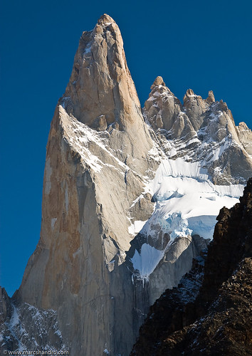
Mount Poincenot, Argentina


Mount Poincenot Argentina, originally uploaded by Marc Shandro.
A granite spire of the Mount Fitz Roy massif in southern Argentina.
You're looking at about 800 meters of vertical granite here.
Cerro Fitz Roy or Monte Fitz Roy, is a mountain ('cerro') located near the El Chaltén village, in the Southern Patagonian Ice Field, inPatagonia, on the border between Argentina and Chile. It is also sometimes called Cerro Chaltén, after the Tehuelche (Aonikenk) word meaning "smoking mountain," due to a cloud that usually forms in the top of the mountain. However it was only one of a number of peaks the Tehuelche called Chaltén.
As he describes in his book, "Viaje a la Patagonia Austral", Francisco Moreno first saw the mountain on 2 March 1877. Since the native inhabitants also called other mountains Chaltén, he named it Fitz Roy, in honour of Robert FitzRoy, who as captain of the Beagle had travelled up the Santa Cruz River in 1834 and charted large parts of the Patagonian coast.
It has been agreed by the two countries that the international border detours eastwards to pass over the main summit, but a large part of the border to the south of the summit, as far as Cerro Murallón remains undefined .
The mountain is the symbol of the Argentine Santa Cruz Province, which includes its representation on its coat of arms.
It was first climbed in 1952 by French alpinists Lionel Terray and Guido Magnone.
The mountain has a reputation of being "ultimate," despite its average height (although being the highest peak in the Los Glaciares park, it is less than half the Himalayan giants), because the sheer granite faces present long stretches of arduous technical climbing. In addition, the weather in the area is exceptionally inclement and treacherous. It also attracts many photographers thanks to its otherworldly shape.
The area, while still fairly inaccessible, was even more isolated until the recent development of El Chalten village and El Calafateinternational airport. The mountain climb, however, remains extremely difficult and is the preserve of very experienced climbers. Today, when a hundred people may summit Mount Everest in a single day, Cerro Chaltén may only be successfully ascended once a year.
Cerro Fitz Roy is the basis for the Patagonia logo following Yvon Chouinard's 3rd ascent and subsequent film in 1968.


"A journey of a thousand miles must begin with a single step." -- Lao Tzu
Copyright © Demetrios the Traveler


Digg!


Saturday, March 21, 2009

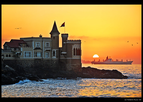
Castillo Wulff, Chile


Atardecer en el Castillo Wulff, originally uploaded by B'Rob.
Centenary Castle Wulff of Viña del Mar is always a good subject for photography. It caught me composition of this late afternoon. I really love this place.

For this residence construction in above mentioned place Wulff had to request a special law that was allowing its constructuin since sea shores belong to Chile State. Areas were acquired by Wulff in 1904, taking effect construction of this chalet between 1905 and 1906 giving end to the building in 1906.

Naval Museum occupied these dependences until ends of 1990 decade, when it is implemented there the Sea Culture Museum.

Castle remains uninhabited a brief time until Municipality recovers it and at present, its spaces have given content to Local Municipality Patrimony Unit.

Thursday, September 25, 2008

Peru a mystery land... Περού η χώρα των θρύλων.


Η ονομασία Περού προέρχεται από το όνομα του Birú, ενός τοπικού άρχοντα στον Κόλπο του Σεν Μιγκέλ στον Παναμά στις αρχές του 16ου αιώνα. Όταν οι κτήσεις του προσπελάστηκαν από Ισπανούς εξερευνητές το 1522, ήταν το νοτιότερο κομμάτι του Νέου Κόσμου. Έτσι, ο Φρανσίσκο Πιζάρο ονόμασε τις νοτιότερες περιοχές Περού. Το ισπανικό Στέμμα κατέστησε νόμιμη την ονομασία το 1529, όταν κατέστησε την Αυτοκρατορία των Ίνκας επαρχία του Περού.
Το Περού (Perú), είναι χώρα στη νότια Αμερική. Συνορεύει βόρεια με τον Ισημερινό και την Κολομβία, ανατολικά με τη Βραζιλία, νοτιοανατολικά με τη Βολιβία, νότια με τη Χιλή και δυτικά με τον Ειρηνικό Ωκεανό. Το Περού είναι μια χαρακτηριστική χώρα της περιοχής των Άνδεων. Έχει έκταση 1.300.000 τ.χλμ. , δηλαδή 10 φορές μεγαλύτερη από την έκταση της Ελλάδας και έχει 22.000.000 κατοίκους.
Οι περουβιανές πόλεις είναι πολυπολιτισμικές με έναν πλούσιο πολιτισμό και ιστορία που είναι αποτέλεσμα της σύγκρουσης του πολιτισμού των Άνδεων με αυτό των Ισπανών αποίκων. Παγκοσμίως η χώρα είναι γνωστή ως το κέντρο του πολιτισμού των Ίνκας.
Η Δημοκρατία του Περού είναι προεδρική. Πρόεδρος είναι, από το 2006, ο Άλαν Γκαρσία. Πρωθυπουργός είναι ο Χόρχε ντελ Καστίγιο.

"A journey of a thousand miles must begin with a single step." -- Lao Tzu
Copyright © Demetrios the Traveler


Digg!


Sunday, June 1, 2008

uncontacted tribes.... "Αγριες", αγνωστες φυλές στον Αμαζόνιο

Πάνω από εκατό φυλές σε όλο τον κόσμο, έχουν επιλέξει την απομόνωση και την απόρριψη κάθε επαφής με τον «έξω κόσμο».
Είναι οι πιο τρωτοί λαοί στον πλανήτη.
Πολλοί από αυτούς «ζουν» σε μια διαρκή φυγή, από τους εισβολείς του εδάφους τους από αποίκους, εμπόρους ξυλείας, εταιρείες πετρελαίου και τα οργανωμένα κοπάδια βοοειδών. Έχουν δει συχνά τους φίλους τους και τις οικογένειες τους να πεθαίνουν στα χέρια των ξένων, στις "μη καταγγελθείσες σφαγές" ή τις επιδημίες που έφερε η «επαφή».

Τα μέλη μιας από τις τελευταίες «άγριες» φυλές, φωτογραφήθηκαν από τον αέρα κοντά στα σύνορα Βραζιλίας-Περού. Οι φωτογραφίες λήφθηκαν κατά τη διάρκεια πτήσεων πάνω από ένα από τα πιο απομακρυσμένα μέρη του τροπικού δάσους της Αμαζονίας στην Acre της Βραζιλίας.

«Κάναμε αρκετές υπερπτήσεις πάνω από το χωρίο για να παρουσιάσουμε τα σπίτια τους, για να δείξουμε ότι βρίσκονται εκεί, για να αποδείξουμε ότι υπάρχουν», είπε ο ειδικός στις άγνωστες φυλές José Carlos dos Reis Meirelles Júnior, που εργάζεται για την FUNAI, το τμήμα υποθέσεων με τους Ινδιάνους της Βραζιλιάνικης κυβέρνησης. Κλείνοντας την συνέντευξη του είπε: «Αυτό είναι πολύ σημαντικό επειδή υπάρχουν μερικοί που αμφιβάλλουν για την ύπαρξή τους.»


"A journey of a thousand miles must begin with a single step." -- Lao Tzu
Copyright © Demetrios the Traveler


Digg!

Wednesday, March 5, 2008

Στις ανεμοδαρμένες Άνδεις,

ενα αρκετα κατατοπιστικο αρθρο εδω:


"A journey of a thousand miles must begin with a single step." -- Lao Tzu
Copyright © Demetrios the Traveler

Saturday, February 16, 2008

let the journey begin ...το ταξίδι αρχίζει

ήρθε η ώρα
time comes


journey beggins

το ταξίδι αρχίζει


στα ωραιότερα μέρη

to the most picturesque places

historic cities

ιστορικές πόλεις

ταξίδια στο διάστημα

or orbiting the globe


to earth's paradise places

σε παραδεισένια μέρη

ταξιδέψτε με την φαντασία σας ή πραγματικά

travel with your fantasy or for real

will be here to assit you with info & travel tips

θα είμαστε εδώ να σας δώσουμε πληροφορίες και προτάσεις

"A journey of a thousand miles must begin with a single step." -- Lao Tzu
Copyright © Demetrios the Traveler

readers

labels and tags

Powered By Blogger