
The Hunyad Castle (Romanian: Castelul Huniazilor or Castelul Corvineştilor, Hungarian: Vajdahunyad vára) is a Gothic-Renaissance castle in Hunedoara (Transylvania), present-day Romania.
The castle is a relic of the Hunyadi dynasty. In 1409, the castle was given to John Hunyadi's father, Voyk, by Sigismund, king of Hungary, as severance. The castle was restored between 1446 and 1453 by his son John Hunyadi. It was built mainly in Gothic style, but has Renaissance architectural elements. It features tall and strong defense towers, an interior yard and a drawbridge. Built over the site of an older fortification and on a rock above the small river Zlaşti, the castle is a large and imposing building with tall and diversely colored roofs, towers and myriad windows and balconies adorned with stone carvings.
The current castle is the result of a fanciful restoration campaign undertaken after a disastrous fire and many decades of total neglect. It has been noted that modern "architects projected to it their own wistful interpretations of how a great Gothic castle should look"
From Wikipedia, the free encyclopedia
Monday, March 28, 2011
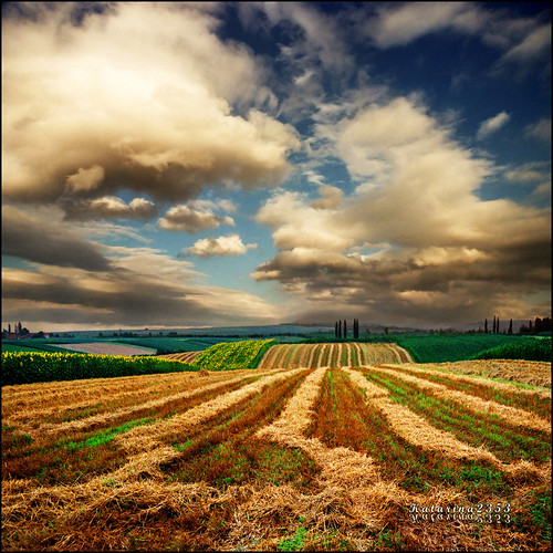
Hunyad Castle, Hunedoara - Romania
Saturday, March 26, 2011
the Pannonian Plain, Central Europe
The Pannonian Plain is a large plain in Central Europe that remained when the Pliocene Pannonian Sea dried out. It is a geomorphological subsystem of the Alps-Himalaya system.
The river Danube divides the plain roughly in half.
The plain is divided among Austria, Bosnia and Herzegovina, Croatia, the Czech Republic, Hungary, Romania, Serbia, Slovakia, Slovenia and Ukraine.
The plain is roughly bounded by the Carpathian mountains, the Alps, the Dinaric Alps and the Balkan mountains.
Although rain is not plentiful, it usually falls when necessary and the plain is a major agricultural area; it is sometimes said that these fields of rich loamy loess soil could feed the whole of Europe. For its early settlers, the plain offered few sources of metals or stone. Thus when archaeologists come upon objects of obsidian or chert, copper or gold, they have almost unparalleled opportunities to interpret ancient pathways of trade.
The precursor to the present plain was a shallow sea that reached its greatest extent during the Pliocene, when three to four kilometres of sediments were deposited.
The plain was named after the Pannonians, a northern Illyrian tribe. Various different peoples inhabited the plain during its history. In the first century BC, the eastern parts of the plain belonged to the Dacian state, and in the first century AD its western parts were subsumed into the Roman Empire. The Roman province named Pannonia was established in the area, and the city of Sirmium, today Sremska Mitrovica, Serbia, became one of the four capital cities of the Roman Empire in the 3rd century.
en.wikipedia.org/wiki/Pannonian_Plain
Las Vegas, Nevada USA
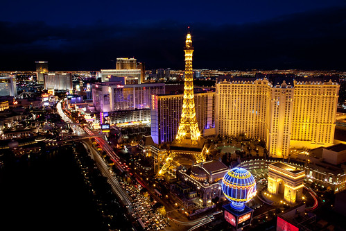
Las Vegas (pronounced /lɑːs ˈveɪɡəs/) is the most populous city in Nevada, United States, the seat of Clark County, and an internationally renowned major resort city for gambling, shopping and fine dining. Las Vegas, which bills itself as The Entertainment Capital of the World, is famous for the number of casino resorts and associated entertainment. A growing retirement and family city, it is the 28th most populous city in the United States with an estimated population by the U.S. Census Bureau of 583,756 as of 2010. The 2010 population estimate of the Las Vegas metropolitan area was 1,951,269.
Established in 1905, Las Vegas officially became a city in 1911. With the growth that followed, at the close of the century Las Vegas was the most populous American city founded in the 20th century (a distinction held by Chicago in the 19th century). The city's tolerance for various forms of adult entertainment earned it the title of Sin City, and this image has made Las Vegas a popular setting for films and television programs. There are numerous outdoor lighting displays on Fremont Street, as well as elsewhere in the city.
The name Las Vegas is often applied to unincorporated areas that surround the city, especially the resort areas on and near the Las Vegas Strip. The 4.2 mi (6.8 km) stretch of Las Vegas Boulevard known as the Strip is mainly in the unincorporated communities of Paradise and Winchester, while a small portion overlaps into Las Vegas and the unincorporated community of Enterprise.
Malta - Mdina

Mdina, Città Vecchia, or Città Notabile, (English: Notabile, or Imdina) is the old capital of Malta. Mdina is a medieval walled town situated on a hill in the centre of the island. Punic remains uncovered beyond the city’s walls suggest the importance of the general region to Malta’s Phoenician settlers. Mdina is commonly called the "Silent City" by natives and visitors. The town is still confined within its walls, and has a population of less than three hundred, but it is contiguous with the village of Rabat, which takes its name from the Arabic word for suburb, and has a population of over 11,000.
more @ wikipedia
Santorini, Greece
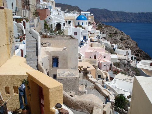
Santorini (Greek: Σαντορίνη, pronounced [sadoˈrini]), officially Thera (alternative spelling Thira, Greek Θήρα [ˈθira]) is a volcanic island located in the southern Aegean Sea, about 200 km (120 mi) southeast from Greece's mainland. It is the largest island of a small, circular archipelago which bears the same name. It forms the southernmost member of the Cyclades group of islands, with an area of approximately 73 km2 (28 sq mi) and a 2001 census population of 13,670. It is composed of the Municipality of Thira (pop. 12,440) and the Community of Oía (Οία, pop. 1,230, which includes 268 inhabitants resident on the offshore island of Therasia, lying to the west). These have a total land area of 90.623 km2 (34.990 sq mi), which also includes the uninhabited islands of Nea Kameni, Palaia Kameni, Aspronisi, and Christiana (all part of the Municipality of Thira).
Santorini is essentially what remains of an enormous volcanic explosion, destroying the earliest settlements on what was formerly a single island, and leading to the creation of the current geological caldera.
A giant central lagoon, more or less rectangular, and measuring about 12 by 7 km (7.5 by 4.3 mi), is surrounded by 300 m (980 ft) high steep cliffs on three sides. The island slopes downward from the cliffs to the surrounding Aegean Sea. On the fourth side, the lagoon is separated from the sea by another much smaller island called Therasia; the lagoon merges with the sea in two places, in the northwest and southwest. The water in the centre of the lagoon is nearly 400 m (1,300 ft) deep, thus making it a safe harbour for all kinds of shipping. The island's harbours all lie in the lagoon and there are no ports on the outer perimeter of the island; the capital, Fira, clings to the top of the cliff looking down on the lagoon. The volcanic rocks present from the prior eruptions feature olivine and have a notably small presence of hornblende.
It is the most active volcanic centre in the South Aegean Volcanic Arc, though what remains today is chiefly a water-filled caldera. The volcanic arc is approximately 500 km long and 20–40 km wide. The region first became volcanically active around 3–4 million years ago though volcanism on Thera began around 2 million years ago with the extrusion of dacitic lavas from vents around the region of Akrotiri.
The island is the site of one of the largest volcanic eruptions in recorded history: the Minoan eruption (sometimes called the Thera eruption), which occurred some 3,600 years ago at the height of the Minoan civilization. The eruption left a large caldera surrounded by volcanic ash deposits hundreds of feet deep and may have led indirectly to the collapse of the Minoan civilization on the island of Crete, 110 km (68 mi) to the south, through the creation of a gigantic tsunami. This theory is not, however, supported by chronology, in that the collapse of the Minoan civilization did not occur concurrently with the date of the Tsunami; that happened some 90 years later.[citation needed] Another popular theory holds that the Thera eruption is the source of the legend of Atlantis.
via From Wikipedia, the free encyclopedia
Friday, March 25, 2011
Tour Eiffel........ Paris France
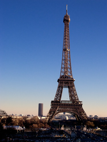
The Eiffel Tower (French: La Tour Eiffel, [tuʁ ɛfɛl], nickname La dame de fer, the iron lady) is an iron lattice tower located on the Champ de Mars in Paris. Built in 1889, it has become both a global icon of France and one of the most recognizable structures in the world. The tower is the tallest building in Paris and the most-visited paid monument in the world; millions of people ascend it every year. Named for its designer, engineer Gustave Eiffel, the tower was built as the entrance arch to the 1889 World's Fair.
The tower stands 324 metres (1,063 ft) tall, about the same height as an 81-story building. Upon its completion, it surpassed the Washington Monument to assume the title of tallest man-made structure in the world, a title it held for 41 years, until the Chrysler Building in New York City was built in 1930; however, due to the addition in 1957 of the antenna, the tower is now taller than the Chrysler Building. Not including broadcast antennas, it is the second-tallest structure in France after the 2004 Millau Viaduct.
The tower has three levels for visitors. Tickets can be purchased to ascend, by stairs or lift, to the first and second levels. The walk to the first level is over 300 steps, as is the walk from the first to the second level. The third and highest level is accessible only by elevator. Both the first and second levels feature restaurants.
The tower has become the most prominent symbol of both Paris and France, often in the establishing shot of films set in the city.
Indus,Skardu, Pakistan.
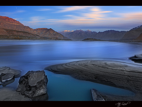
The Indus River (Sanskrit: Sarasvati, Sindhu; Hindi: सिंधु नदी, Sindhu nadī; Avestan: Harauhuti; Urdu: دریائے سندھ, daryā-e sindh; Sindhi: سنڌو Sindhu; Punjabi: سندھ Sindh; Hindko: سندھ Sindh; Avestan: Hapta Hindu; Pashto: اباسين Abāsin "Water of Sindh"; Pashto: السند Al-Sind; Tibetan: སེང་གེ།་གཙང་པོ; Wylie: Sênggê Zangbo "Lion River"; Chinese: 森格藏布/狮泉河/印度河; pinyin: Sēngé Zàngbù/Shīquán Hé/Yìndù Hé; Greek: Ινδός Indós; Turki: Nilab) is a major river which flows through Pakistan.
Originating in the Tibetan plateau of western China in the vicinity of Lake Mansarovar in Tibet Autonomous Region, the river runs a course through the Ladakh district of Jammu and Kashmir and then enters Pakistan via the Northern Areas (Gilgit-Baltistan), flowing through the North in a southerly direction along the entire length of Pakistan, to merge into the Arabian Sea near the port city of Karachi in Sindh. The total length of the river is 3,180 kilometers (1,976 miles) and it is Pakistan's longest river.
The river has a total drainage area exceeding 1,165,000 square kilometers (450,000 square miles). The river's estimated annual flow stands at around 207 cubic kilometers, making it the twenty-first largest river in the world in terms of annual flow. Beginning at the heights of the world with glaciers, the river feeds the ecosystem of temperate forests, plains and arid countryside. Together with the rivers Jhelum, Chenab, Ravi, Sutlej, Beas and two tributaries from the Khyber Pakhtunkhwa and Afghanistan, the Indus forms the Sapta Sindhu (Seven Rivers) delta of Pakistan.
The Indus has formed a natural boundary between the Indian Subcontinent and its frontier with the Iranian Plateau, a region which includes Pakistan's Balochistan, Khyber Pakhtunkhwa as well as Afghanistan, Tajikistan and Iran. It has been crossed by the armies of Alexander the Great - His Macedonian forces retreated along the southern course of the river at the end of the Asian campaign after conquering what is now Pakistan and joining it to the Hellenic Empire. The Indus plains have also been under the domination of the Persian empire and the Kushan empire. The Muslim armies of Muhammad bin Qasim, Mahmud of Ghazni, Mohammed Ghori, Tamerlane and Babur also crossed the river to strike into the inner regions of Punjab and further south east.
city by the sea Thessaloniki Greece
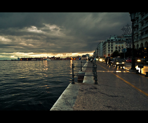
Thessaloniki , is the capital of the region of Central Macedonia, and is, at about a million inhabitants, the second largest city in the country. More importantly, it is a city with a continuous 3,000 year history, preserving relics of its Roman, Byzantine and Ottoman past and of its formerly dominant Jewish population. Its Byzantine churches, in particular, are included in UNESCO's World Heritage list.
http://www.britannica.com/EBchecked/topic/591866/Thessaloniki
Kuzguncuk, Intanbul Turkey

Kuzguncuk is a neighborhood in the Üsküdar district on the Asian side of the Bosphorus in Istanbul, Turkey. The neighborhood is centered on a valley opening to the Bosphorus and is somewhat isolated from the rest of the city, being surrounded by nature preserves, cemeteries, and a military installation. It is a quiet neighborhood with streets lined with antique wooden houses. In the past, it was the home of many Jewish, Armenian, and Greek Istanbulites and very few Muslims. Today, the exact opposite is the case.
Kuzguncuk is bordered on the north by Beylerbeyi, on the east by Burhaniye, on the south by İcadiye and Sultantepe, and on the west by the Bosphorus. On the other side of the Bosphorus is Beşiktaş.
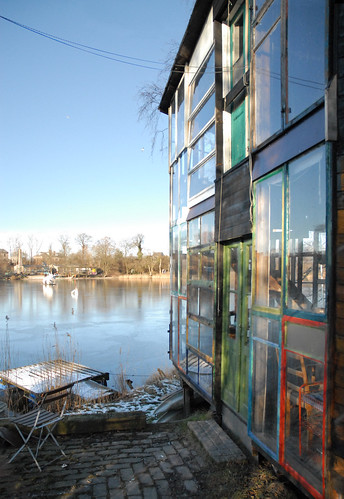
San Francisco from Sausalito, California, USA

Sausalito is a San Francisco Bay Area city, located in Marin County, California, United States. Sausalito is located 8 miles (13 km) south-southeast of San Rafael, at an elevation of 13 feet (4 m). The population was 7,330 as of the year 2000 census. The community is situated near the northern end of the Golden Gate Bridge, and prior to the building of that bridge served as a terminus for rail, car and ferry traffic. Developed rapidly as a shipbuilding center in World War II, the city's industrial character gave way in postwar years to a reputation as a wealthy and artistic enclave, a picturesque residential community (incorporating large numbers of houseboats), and a tourist destination. It is adjacent to, and largely bounded by, the protected spaces of the Golden Gate National Recreation Area.
RUE RIVOLI (París), France
Rue de Rivoli (French pronunciation: [ʁy də ʁivɔli]) is one of the most famous streets of Paris, a commercial street whose shops include the most fashionable names in the world. It bears the name of Napoleon's early victory against the Austrian army, at the battle of Rivoli, fought January 14 and 15, 1797. The rue de Rivoli marked a transitional compromise between an urbanism of prestige monuments and aristocratic squares, and the forms of modern town planning by official regulation.
The new street that Napoleon Bonaparte pierced through the heart of Paris took for one side the north wing of the Louvre, which Napoleon extended, and the Tuileries Gardens. For the first time ever, a handsome, regular, wide street would face the north wing of the old palace. Napoleon's original section of the street opened up eastward from the Place de la Concorde. Builders on the north side of the Place Louis XV, as it then was named, between rue de Mondovi and rue Saint-Florentin, had been constrained by letters patent in 1757 and 1758 to follow a single façade plan. The result was a pleasing uniformity, and Napoleon's planners extended a similar program, which has resulted in the famous arcaded facades that extend for almost a mile.
The restored Bourbon King Charles X continued the rue de Rivoli eastwards from the Louvre, as did King Louis-Philippe. Finally, Emperor Napoleon III extended it on into the 17th-century quarter of the Marais (see: Right Bank). Beneath the rue de Rivoli runs one of the main brick-vaulted oval-sectioned sewers of Paris' much-imitated system, with its sidewalks for the sewerworkers.
In 1852, opposite the wing of the Louvre, Baron Haussmann enlarged the Place du Palais-Royal that is centered on the baroque Palais Royal, built for Cardinal Richelieu in 1624 and willed to the royal family, with its garden surrounded by chic commercial arcades. At the rear of the garden is the older branch of the Bibliothèque Nationale, in rue Richelieu.
North of the rue de Rivoli, at the point where the Grands Boulevards crossed an enormous new square, the new opera house was built. The Opera Garnier is a magnificent monument to the construction of the Second Empire. Just behind the opera house can be found the largest department stores, like the Galeries Lafayette and Printemps.
East along the rue de Rivoli, at the Place des Pyramides, is the gilded statue of Joan of Arc situated close to where she was wounded at the Saint-Honoré Gate in her unsuccessful attack on English-held Paris on September 8, 1429. A little further along, towards the Place de la Concorde, the rue de Castiglione leads to the Place Vendôme, with its Vendôme Column surmounted by the effigy of Napoleon Bonaparte. He began the building of the street in 1802; it was completed in 1865.[1] A plaque at no. 144 commemorates the assassination there of the Huguenot leader Admiral Gaspard de Coligny in the St. Bartholomew's Day massacre of 1572.
Library in Bloom
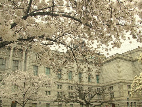
Washington DC's Tidal Basin cherry blossoms are far from being the only cherry blossoms in the city. The U.S. Capitol grounds include many blooming cherry trees and the Library of Congress grounds have several trees as well. Also on the Library grounds are star magnolia trees and a gorgeous Chinese white magnolia. A glimpse of those white blooms (too small a glimpse, I'm sorry to say) can be seen on the far right side of this photo to which I added some texture to make up for today's gloomy light.
The Library of Congress is the research library of the United States Congress, de facto national library of the United States, and the oldest federal cultural institution in the United States. Located in three buildings in Washington, D.C., it is the largest library in the world by shelf space and number of books. The head of the Library is the Librarian of Congress, currently James H. Billington.
The Library of Congress was built by Congress in 1800, and was housed in the United States Capitol for most of the 19th century. After much of the original collection had been destroyed during the War of 1812, Thomas Jefferson sold 6,487 books, his entire personal collection, to the library in 1815. After a period of decline during the mid-19th century the Library of Congress began to grow rapidly in both size and importance after the American Civil War, culminating in the construction of a separate library building and the transference of all copyright deposit holdings to the Library. During the rapid expansion of the 20th century the Library of Congress assumed a preeminent public role, becoming a "library of last resort" and expanding its mission for the benefit of scholars and the American people.
The Library's primary mission is researching inquiries made by members of Congress through the Congressional Research Service. Although it is open to the public, only Members of Congress, Supreme Court justices and other high-ranking government officials may check out books. As the de facto national library, the Library of Congress promotes literacy and American literature through projects such as the American Folklife Center, American Memory, Center for the Book and Poet Laureate.
Castello del Valentino
The Castle of Valentino (Italian Castello del Valentino) is an historic building in the north-west Italian city of Turin. It is located in Valentino Park, and is the seat of the Architecture Faculty of the Polytechnic University of Turin. It is one of the Residences of the Royal House of Savoy included in the list of UNESCO World Heritage Sites in 1997.
[edit]
Thursday, March 24, 2011
Bergen Bryggen, Norway

Bryggen (Norwegian for the Wharf), also known as Tyskebryggen (the German Wharf) is a series of Hanseatic commercial buildings lining the eastern side of the fjord coming into Bergen, Norway. Bryggen has since 1979 been on the UNESCO list for World Cultural Heritage sites. The name has the same origin as the Flemish city of Brugge.
The city of Bergen was founded in 1070. The area of the present Bryggen constitutes the oldest part of the city. Around 1360 a Kontor of the Hanseatic League was established there, and as the town developed into an important trading centre, the wharfs were improved. The buildings of Bryggen were gradually taken over by the Hanseatic merchants. The warehouses were filled with goods, particularly fish from northern Norway, and cereal from Europe.
Throughout history, Bergen has experienced many fires, since, traditionally, most houses were made from wood. This was also the case for Bryggen, and as of today, around a quarter dates back to the time after 1702, when the older wharfside warehouses and administrative buildings burned down. The rest predominantly consists of younger structures, although there are some stone cellars that date back to the 15th century.
Parts of Bryggen were destroyed in a fire in 1955. This area was used for the construction of Bryggen museum containing archeological remains, plus some old-style wooden houses, these being the six leftmost houses on the panoramic picture below. Controversially, a brick hotel was also raised on the premises, which is seen behind these six houses.
Today, Bryggen houses tourist, souvenir, and gift shops, in addition to restaurants, pubs and museums.
Wednesday, March 23, 2011
Lights of Trastevere,Rome ITALY
Trastevere is rione XIII of Rome, on the west bank of the Tiber, south of Vatican City. Its name comes from the Latin trans Tiberim, meaning literally "beyond the Tiber". The correct pronunciation is "tras-TEH-ve-ray", with the accent on the second syllable. Its logo is a golden head of a lion on a red background, the meaning of which is uncertain. To the north, Trastevere borders on to the XIV rione, Borgo.
From Wikipedia, the free encyclopedia
Super Moon over Pittsburgh, Pennsylvania, USA

Pittsburgh (pronounced /ˈpɪtsbərɡ/) is the second-largest city in the U.S. Commonwealth of Pennsylvania and the county seat of Allegheny County. Regionally, it anchors the largest urban area of Appalachia and the Ohio River Valley, and nationally, it is the 22nd-largest urban area in the United States. The population of the city in 2010 was 305,704, while that of the seven-county metropolitan area stood at 2,356,285. Downtown Pittsburgh retains substantial economic influence, ranking at 25th in the nation for jobs within the urban core and 6th in job density. The characteristic shape of Pittsburgh's central business district is a triangular tract carved by the confluence of the Allegheny and Monongahela rivers, which form the Ohio River. The city features 151 high-rise buildings, 446 bridges, two inclined railways, and a pre-revolutionary fortification. Pittsburgh is known colloquially as "The City of Bridges" and "The Steel City" for its many bridges and former steel manufacturing base.
While the city is historically known for its steel industry, today its economy is largely based on healthcare, education, technology, robotics, and financial services. The downturn of the steel industry left no steel mills within the City of Pittsburgh and only two remaining mills in the county. By contrast, the region supports 1,600 technology companies, ranging from a Google campus to small startups.[4] The city has redeveloped abandoned industrial sites with new housing, shopping and offices, such as SouthSide Works and Bakery Square.
While Pittsburgh faced an economic crisis in the 1980s as the regional steel industry waned, modern Pittsburgh is economically strong. The housing market is relatively stable despite a national subprime mortgage crisis, and Pittsburgh added jobs in 2008 even as the national economy entered a significant jobs recession. This positive economic trend is in contrast to the 1980s, when Pittsburgh lost its manufacturing base in steel and electronics, and corporate jobs in the oil (Gulf Oil), electronics (Westinghouse), chemical (Koppers) and defense (Rockwell International) industries.\
From Wikipedia, the free encyclopedia
Torres del Paine, Chile. Colorful Sky over Spectacular Peaks
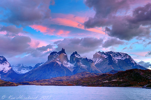
The Cordillera del Paine is a small but spectacular mountain group in Torres del Paine National Park in Chilean Patagonia. It is located 400 km (244 miles) north of Punta Arenas, and about 2,500 km south of the Chilean capital Santiago. It belongs to the Commune of Torres del Paine in Última Esperanza Province of Magallanes y Antártica Chilena Region. No accurate surveys have been published, and published elevations have been claimed to be seriously inflated, so the elevations given on this page are all approximate
more @ wikipedia
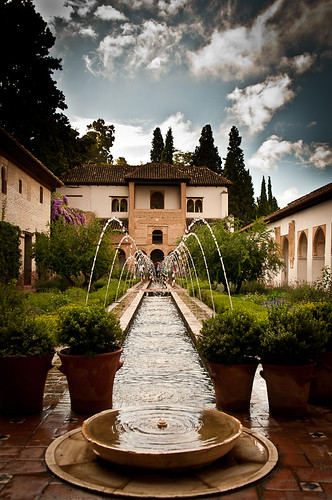
Sunday, March 20, 2011
Generalife, Granada, Andalusia, Spain
.
.
The Palacio de Generalife (Arabic: Jannat al-'Arif - Architect's Garden) was the summer palace and country estate of the Nasrid Emirs (Kings) of the Emirate of Granada in Al-Andalus, now beside the city of Granada in the autonomous community of Andalusia, Spain.
The palace and gardens were built during the reign of Muhammad III (1302–1309) and redecorated shortly after by Abu I-Walid Isma'il (1313–1324).
The complex consists of the Patio de la Acequia (Court of the Water Channel or Water-Garden Courtyard), which has a long pool framed by flowerbeds, fountains, colonnades and pavilions, and the Jardín de la Sultana (Sultana's Garden or Courtyard of the Cypress). The former is thought to best preserve the style of the medieval Persian garden in Al-Andalus.
Originally the palace was linked to the Alhambra by a covered walkway across the ravine that now divides them. The Generalife is one of the oldest surviving Moorish gardens.
The present-day gardens were started in 1931 and completed by Francisco Prieto Moreno in 1951. The walkways are paved in traditional Granadian style with a mosaic of pebbles: white ones from the River Darro and black ones from the River Genil.
The Generalife is a UNESCO World Heritage Site in Granada, along with the Alhambra palace and gardens, and the Albayzín district.
Saturday, March 19, 2011
The Classic View , Monument Valley. Utah USA

Friday, March 18, 2011
Sarlat -France

Sarlat - Frankreich - Middle age - Le Moyen-Âge - Medioevo - france, originally uploaded by Ela2007.
History
Sarlat is a medieval town that developed around a large Benedictine abbeyofCarolingian origin. The medieval Sarlat Cathedral is dedicated to Saint Sacerdos.
Portable still at Sarlat
Because modern history has largely passed it by, Sarlat has remained preserved and one of the towns most representative of 14th century France. It owes its current status on France's Tentative List for future nomination as a UNESCO World Heritage site to the enthusiasm of writer, resistance fighter and politician André Malraux, who, as Minister of Culture (1960-1969), restored the town and many other sites of historic significance throughout France. The centre of the old town consists of impeccably restored stone buildings and is largely car-free.
Sunday, March 13, 2011
Christiania Copenhagen, Denmark
Christiania, also known as Freetown Christiania (Danish: Fristaden Christiania) is a self-proclaimed autonomous neighbourhood of about 850 residents, covering 34 hectares (85 acres) in the borough of Christianshavn in the Danish capital Copenhagen. Civic authorities in Copenhagen regard Christiania as a large commune, but the area has a unique status in that it is regulated by a special law, the Christiania Law of 1989 which transfers parts of the supervision of the area from the municipality of Copenhagen to the state.
Christiania has been a source of controversy since its creation in a squatted military area in 1971. Its cannabis trade was tolerated by authorities until 2004. Since then, measures for normalising the legal status of the community have led to conflicts, and negotiations are ongoing.

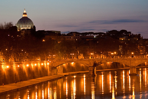
Venice Accademia , when Grand Canal is a sleep, Italy
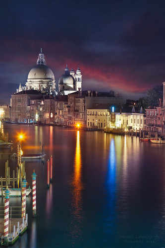
Looking towards southern end of Grand Canal and Chiesa della Salute - Church of Santa Maria della Salute.
In October of 1630, after nearly a third of Venice's 150,000 citizens had been killed by plague, the Venetian Senate made an offer to God: "Stop the plague, and we'll build a church to honor the Virgin Mary."
I was looking for something for the competition and the subject is “ Night “ and I wondered off to Venice. It seams that every time I open files from Venice I find something that I missed before.
What I miss the most it the Venice itself. I would love to go back
(Ósvör in Bolungarvík) Iceland
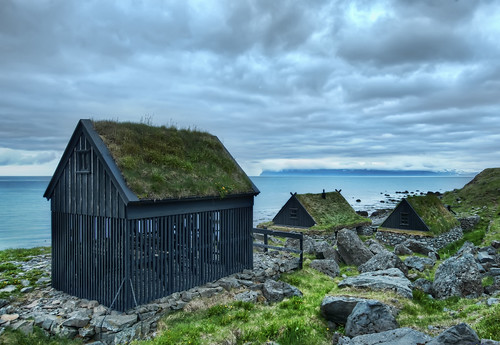
While in the northwest fjords, I came across these little huts with intermittent slats. This is where the fisherman hang the fish to dry in the incessant sea-winds that blow up the coast. Pretty cool, eh?
Wednesday, March 9, 2011
The Matterhorn, Zermatt, Golden peak

The individual pieces of the chocolate bar Toblerone are claimed by its maker Kraft to be formed in the likeness of the Matterhorn.
Zermatt (French: Praborgne) is a municipality in the district of Visp in the German-speaking section of the canton of Valais in Switzerland.
It is located at the northern base of the Matterhorn in the Pennine Alps, about 10 km from the border with Italy.
Zermatt has a permanent population of around 5,500 people, although the actual population varies considerably through the seasons as tourists come and go. The village is situated at the end of Mattertal, a north-facing valley, at an altitude of 1,620m (5,315ft). The valley is a dead end; although the border with Italy is close, it cannot be crossed by road, as it traverses a glacier at an altitude of over 3,000m. Zermatt is the starting point of the Patrouille des Glaciers and the Haute Route.
en.wikipedia.org/wiki/Matterhorn
en.wikipedia.org/wiki/Zermatt
The Alps (French: Alpes; German: Alpen; Italian: Alpi; Romansh: Alps; Slovene: Alpe) is the name for one of the great mountain range systems of Europe, stretching from Austria and Slovenia in the east, through Italy, Switzerland, Liechtenstein and Germany to France in the west. The word "Alps" was taken via French from Latin Alpes (meaning "the Alps"), which may be influenced by the Latin words albus (white) or altus (high) or more likely a Latin rendering of a Celtic or Ligurian original.
The highest mountain in the Alps is Mont Blanc, at 4,808 metres (15,774 ft), on the Italian-French border. All the main peaks of the Alps can be found in the list of mountains of the Alps and list of Alpine peaks by prominence.
The Alps are generally divided into the Western Alps and the Eastern Alps. The division is along the line between Lake Constance and Lake Como, following the Rhine. The Western Alps are higher, but their central chain is shorter and curved; they are located in Italy, France and Switzerland. The Eastern Alps (main ridge system elongated and broad) belong to Austria, Germany, Italy, Liechtenstein, Slovenia and Switzerland.
The Alps are a classic example of what happens when a temperate area at lower altitude gives way to higher elevation terrain. Elevations around the world which have cold climates similar to those found in polar areas have been called alpine. A rise from sea level into the upper regions of the atmosphere causes the temperature to decrease. The effect of mountain chains on prevailing winds is to carry warm air belonging to the lower region into an upper zone, where it expands in volume at the cost of a proportionate loss of heat, often accompanied by the precipitation of moisture in the form of snow or rain.
en.wikipedia.org/wiki/Alps
Tuesday, March 8, 2011
park Guell ...Barcelona Spain
BCN-Gaudí-Park Güell from mylapse on Vimeo.
"A journey of a thousand miles must begin with a single step." -- Lao Tzu Copyright © Demetrios the Traveler
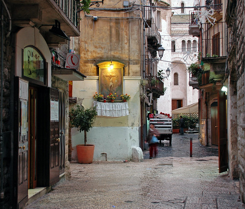
Bari Antica... Italy
Sunday, March 6, 2011
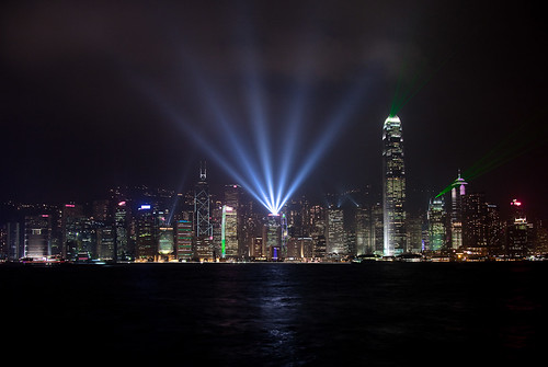
Hong Kong - Best skyline ever
Hanalei Bonfire - Kauai, Hawaii USA
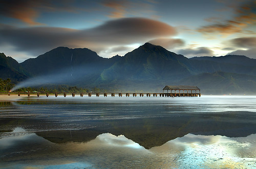
Hanalei is a small town on the north shore of the island of Kauai. It has a 3-mile wide perfect crescent of sandy shoreline with the rainiest mountains in the world right behind them. While it rains about 100 inches per year in Hanalei, it rains about 600 inches per year on Mt. Waialeale, about 5 miles behind the peak on the left.
Even with all of the rain, days are usually sunny in Hanalei with maybe 1-2 hours of rain mostly at night. The mountains in this image range from 3,000 to 5,000 feet in height. This shot can only be done with a medium tide and this effect only lasts for a few minutes before another wave moves in.
Here, I attempted to show one of the waterfalls in the reflection. It took about 15 minutes of fiddling around before I finally got it right. All these elements combine to create a thickness to the atmosphere that makes me feel like I'm right back on the beach every time I view this image
Saturday, March 5, 2011
The Old Pier, North Queensferry, Fife Scotland, UK

I love Paris
"A journey of a thousand miles must begin with a single step." -- Lao Tzu Copyright © Demetrios the Traveler
people are not strange!
Thursday, March 3, 2011
Castle on the Rocks ,Castle Lichtenstein, Germany
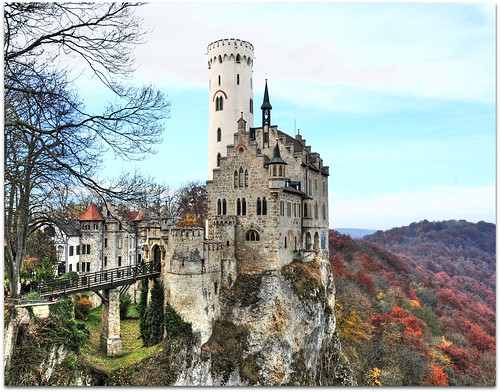
near Reutlingen in autumn environs / Germany
Lichtenstein Castle is situated on a cliff located near Honau in the Swabian Alb, Baden-Württemberg, Germany. Its self-descriptive name in English means "light (colored) stone."
Historically there has been a castle on the site since around 1200. It was twice destroyed, once in the Reichskriegs war of 1311 and again by the city-state of Reutlingen in 1381. The castle was not reconstructed and subsequently fell to ruin.
In 1802 the land came into the hands of King Frederick I of Württemberg, who built a hunting lodge there. By 1837 the land had passed to his nephew Duke Wilhelm of Urach, Count of Württemberg, who, inspired by Wilhelm Hauff's novel Lichtenstein [1], added the current castle in 1840–42. The romantic Neo-Gothic design of the castle was created by the architect Carl Alexander Heideloff.
Today the castle is still owned by the Dukes of Urach, but is open to visitors. The castle contains a large collection of historic weapons and armour.
