The Church of John the Baptist featured in the film "Mamma Mia":
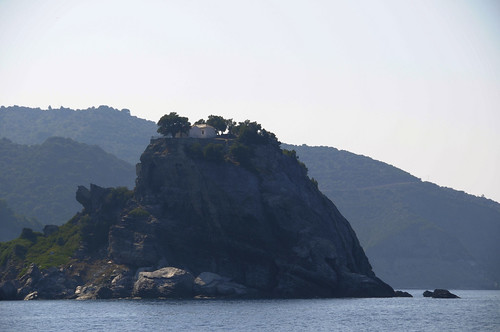
This small church became famous where scenes of the Hollywood movie "Mamma Mia" (2007) were filmed there. In fact, the wedding scenes were shot in that church. The impressive rock is linked to the island with a narrow path and people have to climb 110 stairs to get to the top. A small beach is located above the rock and it gets pretty crowded in summer. The interior of the church has beautiful icons and old ecclesiastical items.
Saturday, July 31, 2010
The "Mamma Mia" Church, Skopelos Greece
Monday, July 19, 2010
Lake Louise, Alberta Canada

Lake Louise is a lake in Alberta, Canada. The glacial lake is located in Banff National Park, 5 km (3 mi) from the hamlet of Lake Louise and the Trans-Canada Highway.
Lake Louise is named after the Princess Louise Caroline Alberta (1848–1939), the fourth daughter of Queen Victoria and the wife of the Marquess of Lorne, who was the Governor General of Canada from 1878 to 1883.
The emerald colour of the water comes from rock flour carried into the lake by melt-water from the glaciers that overlook the lake. The lake has a surface of 0.8 km2 (0.3 sq mi) and is drained through the 3 km long Louise Creek into the Bow River.
The eastern shore of the lake is dominated by Chateau Lake Louise, one of Canada's grand railway hotels, a luxury resort hotel built in the early decades of the 20th century by the Canadian Pacific Railway.
Downtown, Dallas, Texas, USA
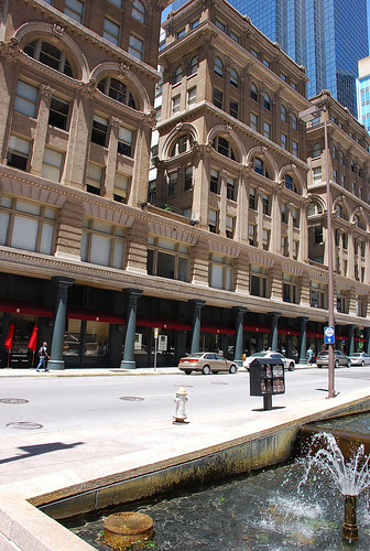
Dallas (pronounced /ˈdæləs/) is the third-largest city in Texas and the ninth-largest in the United States. As of June 22, 2010 the population of Dallas was at 1.3 million according to the US Census Bureau. The city is the largest economic center of the 12-county Dallas–Fort Worth–Arlington metropolitan area that according to the March 2010 U.S. Census Bureau release, had a population of 6.45 million as of July 2009. The metropolitan area is the fourth-largest metropolitan area in the United States.
Founded in 1841 and formally incorporated as a city in February, 1856, the city's economy is primarily based on banking, commerce, telecommunications, computer technology, energy, and transportation, home to several Fortune 500 companies.Located in North Texas and a major city in the American South, Dallas is the core of the largest inland metropolitan area in the United States that lacks any navigable link to the sea. The city's prominence arose from its historical importance as a center for the oil and cotton industries, its position along numerous railroad lines, a strong industrial and financial sector, and its status as a major inland port (due largely to the presence of Dallas/Fort Worth International Airport, one of the largest and busiest in the world). It was rated as a beta world city by the Globalization and World Cities Study Group & Network.
Itanos beach, Crete, Greece
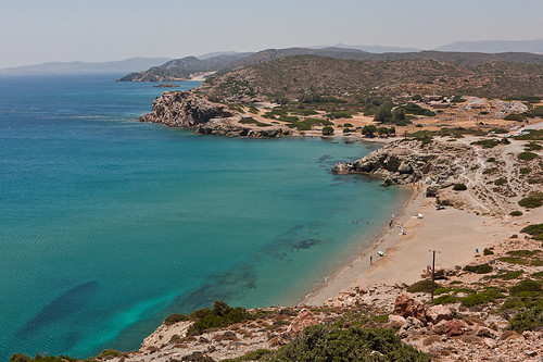
Itanos (Greek: Ίτανος) is a municipality in the Lasithi prefecture, Crete, Greece named after the ancient Cretan city Utana (cf. Linear B u-ta-ni-yo [KN E 749]). Population 2,514 (2001). The seat of the municipality is in Palaiokastro.
Kavala, Macedonia, Greece
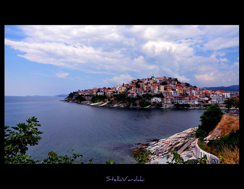
Kavala (Greek: Καβάλα), is the second largest city in northern Greece, the principal seaport of eastern Macedonia and the capital of Kavala prefecture. It is situated on the Bay of Kavala, across from the island of Thasos.
source and more info: @ http://en.wikipedia.org/wiki/Kavala
Saturday, July 17, 2010
Paris ~ Ontario, Canada

Paris has often been referred to as "The prettiest little town in Ontario" and it does have some beautiful vistas.
This is a rather famous view of the water front but I have never been here when it was early morning and the sun was hitting the walls.
The fog adds a nice extra dimension that balances the modern changes being made to the buildings farther down.
Thursday, July 15, 2010
Neil Armstrong’s First Steps on the Moon
Armstrong was born on August 5, 1930 in Wapakoneta, Ohio. At an early age, he was fascinated by airplanes. On his sixteenth birthday, Armstrong was issued a pilot’s license and he even built a small wind tunnel in his basement where he did experiments on model planes. After two years at Purdue University he was called to active duty with the Navy where he flew 78 combat missions during the Korean War. When he returned from the war he completed his degree in aeronautical engineering. He then became a test pilot at the NCAA High Speed Flight Station at Edwards Air Force Base in California. In September 1962, Armstrong became America’s first civilian astronaut and began training in Houston, Texas. He was an alternate command pilot for the Gemini 5 and was command pilot for Gemini 8 in 1966 where he fixed a malfunction that made the vehicle go out of control, landing within 1.1 nautical miles of the intended landing point. He went back to his training and was an alternate for Gemini 11 but he impressed those who would choose the first crew to go to the moon. In January 1969 he was chosen as commander of the Apollo 11 mission that would land on the moon. Armstrong, Michael Collins and Edwin “Buzz” Aldrin lifted off from the Kennedy Space Center at 9:32am on July 16, 1969. Their successful journey took four days and they landed on the moon on July 20 with the world watching and listening on TV and radio. At 10:56pm Armstrong became the first person to set foot on the moon, saying “That’s one small step for (a) man, one giant leap for mankind.” Armstrong and Aldrin spent two hours walking on the moon, deploying a seismograph and wind particle collector and collecting rock and soil samples.
The Guides
Armstrong and the other members of the Apollo 11 team were guided from the ground by a group of hundreds of flight controllers, each of whom responsible for a single operation of the vehicle. They were headed by Flight Director, Gene Kranz, who was also the Flight Director for Gemini 4 and odd-numbered Apollo missions, most notably he was responsible for bringing Apollo 13 home safely.
"A journey of a thousand miles must begin with a single step." -- Lao Tzu Copyright © Demetrios the Traveler
White Sands, New Mexico, USA
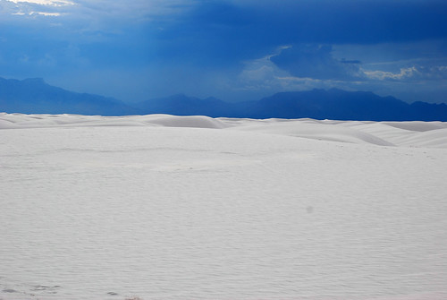
The desert is located in Tularosa Basin New Mexico. Its white sands are not composed of quartz, unlike most desert sands, but of gypsum and calcium sulfate. Unlike other desert sands, it is cool to the touch, due to the high rate of evaporation of surface moisture and the fact that the sands reflect, rather than absorb, the sun's rays. At 1185 meters above sea level, there are approximately 442 total square kilometers of dune fields and is known to be the world's largest surface deposit of gypsum.[3]
Gypsum is one of the most common mineral compounds found on Earth but is rarely seen on the surface, as it dissolves easily in water. The origin of this desert dates back to around 100 million years ago, during which it was covered by a shallow sea. As its waters gradually receded, saltwater lakes were left behind, which eventually evaporated in the sun. In addition to the salt, gypsum was also laid down in thick deposits on the old seabed.
The Sacramento and San Andres Mountains, with the Tularosa Basin between them, took shape approximately 250 million years ago. Giant upheavals in the Earth's crust distorted the land along with the gypsum deposits, forcing them high into the air about 70 million years ago.[4] Rainfall and melt water came from the mountains causing the gypsum to percolate out and the concentrated solutions were washed down the mountainsides. The gypsum solution accumulated in Lake Lucero, the lowest part of the Tularosa Basin. Water in the lake does not have any means of escaping except by evaporation, which leaves behind thin layers of crystallized gypsum, or selenite. Weathering then reduced these crystals to fine, sandy grains. Winds then carried the grains farther up the basin, and the grains piled in steep dunes that often reach as high as 15 m (50 ft). The winds carved more dunes and, while at the same time, carried small amounts of the gypsum grains by distances of up to 9 m (30 ft) a year.
This constant movement still occurs today, and with the added alkaline and the little amount of rainfall makes it difficult for plants to grow here leaving the desert desolate as it appears today.
source: Wikipedia
Monday, July 12, 2010

Thursday, July 8, 2010
Shoreham, near Sevenoaks, Kent, UK
Shoreham is a village and civil parish in the valley of the River Darent six miles north of Sevenoaks in Kent: it is in the District of Sevenoaks. The parish includes the settlements of Badgers Mount and Well Hill.
The probable derivation of the name is estate at the foot of a steep slope. Steep slope was from the Saxon word scor. pronounced shor, but written sore by Norman scribes.
The village of Shoreham contains four traditional independent pubs: Ye Olde George Inne, The King's Arms, The Two Brewers and the Crown; with another in nearby Twitton.
sources: various Wikipedia, Brittanica etc
more info @: http://www.hopshop.co.uk/
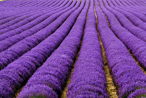
Lavender
The use of lavender has been recorded for more than 2,500 years. Egyptians, Phoenicians and the people of Arabia used lavender as a perfume -- and also for mummification, by wrapping the dead in lavender-dipped shrouds. In ancient Greece, lavender was called "nardus," "nard," or "spikenard" (named for the Syrian city of Naarda) and was used as a cure for everything from insomnia and aching backs to insanity. By Roman times, lavender had already become a prized commodity. Lavender flowers were sold to ancient Romans for 100 denarii per pound -- equivalent to a full month's wage for a farm laborer -- and were used to scent the water in Roman baths. In fact, the baths served as the root of the plant's current name. "Lavender" is derived from the Latin lavare, meaning, "to wash." Romans also used lavender as a perfume, insect repellent and flavoring. They even added dried lavender to their smoking mixtures.
Few plants are burdened with as much folklore and legend as lavender. Some of the stories are contradictory, or at least historically out of sync. One legend says the plant gained its perfume when the Virgin Mary dried the clothes of the baby Jesus on a bush, which from then on was aromatic. However, even before that, Cleopatra was said to use the scent to seduce Julius Caesar and Mark Antony. Another favorite piece of folklore is that if lavender flowers are placed between bed sheets, spouses will never quarrel.
This is a field at Castle Farm,
Saint-Rémy-de-Provence, France.
The village of St. Rémy is pretty and picturesque, and the old Gallo-Roman interior is circled by the remnants of the circular 14th-century wall and the protective circle of buildings.
Located on the plains at the northern edge of the Alpilles, 20 km south of Avignon, this is where Van Gogh painted Starry Night, Nostradamus was born and Dr Albert Schweitzer was prisoner.
The most obvious remains of the 14th-century protective wall are the old portes, still in use today as the entrance ways into the ancient center of old Saint Remy. The old center is circled by a ring-road of boulevards, small enough that you can walk around the circumference in 20-30 minutes.
The ancient Porte du Trou (or Portail Trou de l'Orme) [photo-5] is on the northen edge of the old town. Entering here, you would walk down Rue Nostradamus, and find the Nostradamus fountain [photo-9].
At the opposite end of the old town, the Portail Saint-Paul [photo-4] gives entrance from the south, onto Rue de la Commune leading in to the main Place Pelissier where the town hall (mairie) is located.
The dolphin fountain (photo) from the beginning of the 19th century is located in the shaded square in front of the Mairie. That lovely building (larger photo, 22k) is from the 16th century and is on the site of an old convent.
Saint Remy is a busy, active village, with a good selection of restaurants and hotels for the traveller. Among the shops in the old village are a few with some regional pottery, including some beautiful sunflower plates no doubt influenced by Van Gogh [who lived here].
The road between St. Rémy and the autoroute (at Cavaillon, 17 km to the east) is a scenic drive out of the past: the road is lined by plane trees that are lovely and give beautiful shade during the summer, yet menacing for the imprudent driver.
Market Day
Wednesday is a major market day in Saint Rémy-de-Provence. The market spreads across parking areas and squares around the northern and western parts of the Boulevards ringing the old town of St Rémy. If you like markets, crowds, and an active experience, Wednesday is a great day to visit. Cafés and restaurants tend to be crowded around lunch time, but the atmosphere is good.
There's a smaller market on Saturdays, with food only.
Residents more recent than the Romans include Dr. Schweitzer, Dr. Nostradamus and Van Gogh.
Nostradamus, known in ancient France as an outstanding physician and elsewhere in the world as prophet, was born here on the rue Hoche.
Doctor Albert Schweitzer was "hospitalized" here in 1917-18, for the remainder of the war. He wasn't so much ill as German. He took advantage of his "hospitalization" to write The Decay and the Restoration of Civilization and Civilization and Ethics, part of his philosophical study of civilization.
Vincent Van Gogh had been living in Arles during 1888-89. In May 1889 he was voluntarily confined in the Asylum of Saint-Paul-de-Mausole beside Saint-Rémy. During this period of his life he painted two of his most notable works: Starry Night and Self-Portrait. He was released from the hospital in May 1890 and left for Auvers-sur-Oise, near Paris. He shot himself on 27 July 1890 and died two days later.
Paparazzi Notes (accuracy accidental). Caroline of Monaco lives here, and the late Princess Diana bought a place
source & more info @: http://www.beyond.fr/villages/st-remy-de-provence-france.html
Gourdon's Garden - Provence - France
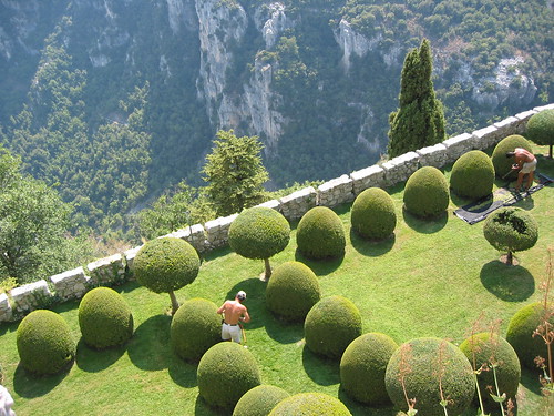
The Castle of Gourdon is close by Saint Paul de Vence - Provence, on the top of mountain. Its gardens were designed by Le Notre, Louix XIV's gardener who also did Versailles park. The picture shows the very precise hard work done by the gardeners, resulting in the geometrical shapes of the trees and golf like lawn, AND the view of the impressive canyon below the garden. When taking the shot, I deliberately choosed to frame it in those two parts (garden and canyon with the white wall being the middle line). The two gardeners, feeling the heat of the summer season, add a human touch to the picture.
Provence in general, St Paul de Vence and Gourdon in particular are great places to visit and photograph.
Collegebrug, Kortrijk, Belgium
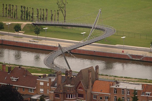
The College Bridge - with a length of 207meter over the Leie - winds between Diksmuidekaai and the corner of the Ijzer- and Damkaai. The cost of this steel bicycle and pedestrian bridge is up 4.1 million euros.
Subscribe to:
Posts (Atom)
