, in the Corse-du-Sud department of France. Its inhabitants are called Bonifaciens, feminine Bonifaciennes. The commune in this case is identical to the canton and is the largest commune of Corsica.
Bonifacio is located directly on the Mediterranean Sea, separated from Sardinia by the Strait of Bonifacio. It is a city placed on the best and only major harbor of the southern coast and also is a commune covering a somewhat larger region including the offshore Isles Lavezzi, giving it the distinction of being the southernmost commune in Metropolitan France. The commune is bordered on the northwest by the canton of Figari and has a short border on the northeast with the canton of Porto-Vecchio. The combined border runs approximately from the Golfe de Ventilegne on the west to the mouth of the Golfu di Sant'Amanza on the east. The coastline circumscribed by the two points is about 75 kilometres (47 mi). Highway N198 runs north along the east coast and N196 along the west.
The islands are part of the French portion, 794.6-square-kilometre (196,300-acre), of the international Bouches de Bonifacio ("Strait of Bonifacio") marine park, a nature reserve, signed into legal existence by France and Italy in 1993 for the protection of the strait against passage of ships bearing dangerous chemicals, and implemented in France by a ministerial decree of 1999 detailing the land to be included in the réserve naturelle de Bouches de Bonifacio for the preservation of wild birds, other fauna and flora, fish and nature in general.
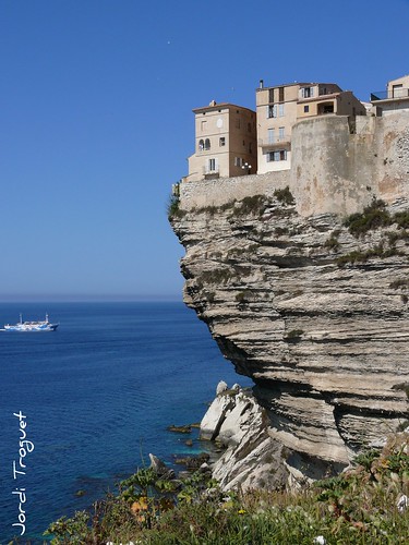
The southern coast in the vicinity of Bonifacio is an outcrop of chalk-white limetone, precipitous and sculpted into unusual shapes by the ocean. Slightly further inland the limestone adjoins the granite of which the two islands, Sardinia and Corsica, are formed. The port of Bonifacio is placed on the Bay of Bonifacio, a drowned ravine of a fjord-like appearance separated from the ocean by a finger-like promontory 1,500 meters (4,900 ft) long and 200 meters (660 ft) wide. In prehistoric post-glacial times when sea levels were low and the islands were connected, the ravine was part of a valley leading to upland Corsica. The maximum draught supported by the harbor is 3.5 meters (11 ft), more than ample for ancient ships and modern small vessels.
The city of Bonifacio is split into two sections. The vieille ville (old town), or la Haute Ville (the Upper city), on the site of a citadel, is located on the promontory overlooking the Mediterranean Sea. The citadel was built in the 9th century with the foundation of the city. The Citadel has been reconstructed and renovated many times since its construction and most recently was an administrative center for the French Foreign Legion. Today it is more of a museum. Historically most of the inhabitants have resided in the Haute ville under the immediate protection of the citadel. The harbor facilities and residential areas below, la marine, line the narrow shelf of the inlet and extend for some distance up the valley, giving the settlement a linear appearance and creating a third residential section limited by St. Julien on the east.
The city and its fortifications also extend for some distance along the cliff-tops, which are at about 70 meters (230 ft) elevation. The cliffs have been undercut by the ocean so that the buildings, which have been placed on the very lip of the precipice, appear to overhang it. The appearance from the sea is of a white city gleaming in the sun and suspended over the rough waters below.
source: http://en.wikipedia.org/wiki/Bonifacio
Bonifacio is located directly on the Mediterranean Sea, separated from Sardinia by the Strait of Bonifacio. It is a city placed on the best and only major harbor of the southern coast and also is a commune covering a somewhat larger region including the offshore Isles Lavezzi, giving it the distinction of being the southernmost commune in Metropolitan France. The commune is bordered on the northwest by the canton of Figari and has a short border on the northeast with the canton of Porto-Vecchio. The combined border runs approximately from the Golfe de Ventilegne on the west to the mouth of the Golfu di Sant'Amanza on the east. The coastline circumscribed by the two points is about 75 kilometres (47 mi). Highway N198 runs north along the east coast and N196 along the west.
The islands are part of the French portion, 794.6-square-kilometre (196,300-acre), of the international Bouches de Bonifacio ("Strait of Bonifacio") marine park, a nature reserve, signed into legal existence by France and Italy in 1993 for the protection of the strait against passage of ships bearing dangerous chemicals, and implemented in France by a ministerial decree of 1999 detailing the land to be included in the réserve naturelle de Bouches de Bonifacio for the preservation of wild birds, other fauna and flora, fish and nature in general.
The southern coast in the vicinity of Bonifacio is an outcrop of chalk-white limetone, precipitous and sculpted into unusual shapes by the ocean. Slightly further inland the limestone adjoins the granite of which the two islands, Sardinia and Corsica, are formed. The port of Bonifacio is placed on the Bay of Bonifacio, a drowned ravine of a fjord-like appearance separated from the ocean by a finger-like promontory 1,500 meters (4,900 ft) long and 200 meters (660 ft) wide. In prehistoric post-glacial times when sea levels were low and the islands were connected, the ravine was part of a valley leading to upland Corsica. The maximum draught supported by the harbor is 3.5 meters (11 ft), more than ample for ancient ships and modern small vessels.
The city of Bonifacio is split into two sections. The vieille ville (old town), or la Haute Ville (the Upper city), on the site of a citadel, is located on the promontory overlooking the Mediterranean Sea. The citadel was built in the 9th century with the foundation of the city. The Citadel has been reconstructed and renovated many times since its construction and most recently was an administrative center for the French Foreign Legion. Today it is more of a museum. Historically most of the inhabitants have resided in the Haute ville under the immediate protection of the citadel. The harbor facilities and residential areas below, la marine, line the narrow shelf of the inlet and extend for some distance up the valley, giving the settlement a linear appearance and creating a third residential section limited by St. Julien on the east.
The city and its fortifications also extend for some distance along the cliff-tops, which are at about 70 meters (230 ft) elevation. The cliffs have been undercut by the ocean so that the buildings, which have been placed on the very lip of the precipice, appear to overhang it. The appearance from the sea is of a white city gleaming in the sun and suspended over the rough waters below.
source: http://en.wikipedia.org/wiki/Bonifacio

No comments:
Post a Comment