Adventures of a traveling blogger
View more presentations from Preetam Rai.
"A journey of a thousand miles must begin with a single step." -- Lao Tzu
Copyright © Demetrios the Traveler
Harrisburg is the capital of the Commonwealth of Pennsylvania, in the United States of America. As of the 2000 census, the city had a population of 48,950, making it the ninth largest city in Pennsylvania, after Philadelphia, Pittsburgh, Allentown, Erie, Reading, Scranton, Bethlehem and Lancaster.
Harrisburg is the county seat of Dauphin County and lies on the east bank of the Susquehanna River, 105 miles (169 km) west-northwest of Philadelphia. The Harrisburg-Carlisle Metropolitan Statistical Area, which includes Dauphin, Cumberland, and Perry counties, had a population of 509,074 in 2000. A July 1, 2007 estimate placed the population at 528,892, making it the fifth largest Metropolitan Statistical Area in Pennsylvania after Philadelphia, Pittsburgh, Allentown-Bethlehem-Easton (the Lehigh Valley), and Scranton-Wilkes Barre. The Harrisburg-Carlisle-Lebanon Combined Statistical Area, including both the Harrisburg-Carlisle and Lebanon Metropolitan Statistical Areas, had an estimated population of 656,781 in 2007.
Harrisburg played a notable role in American history during the Westward Migration, the American Civil War, and the Industrial Revolution. During part of the 19th century, the building of the Pennsylvania Canal and later the Pennsylvania Railroad allowed Harrisburg to become one of the most industrialized cities in the Northeastern United States. The U.S. Navy ship USS Harrisburg, which served from 1918 to 1919 at the end of World War I, was named in honor of the city.
In the mid-to-late 20th century, the city's economic fortunes have fluctuated with its major industries consisting of government, heavy manufacturing including the production of steel, agriculture (the greater Harrisburg area is at the heart of the fertile Pennsylvania Dutch Country), and food services (nearby Hershey is home of the chocolate maker, located just 10 miles east of Harrisburg).
In 1981, following contractions in the steel and dairy industries, Harrisburg was declared the second most distressed city in the nation. The city subsequently experienced a resurgence under its former mayor Stephen R. Reed, with nearly $3 billion in new investment realized during his lengthy tenure.
The Pennsylvania Farm Show, the largest free indoor agriculture exposition in the United States, was first held in Harrisburg in 1917 and has been held there every January since then. Harrisburg also hosts an annual outdoor sports show, the largest of its kind in North America, as well as an auto show, which features a large static display of new as well as classic cars and is renowned nation-wide. Harrisburg is also known for the infamous Three Mile Island accident, which occurred in 1979 in nearby Middletown.
THE CLIFFS OF MOHER
on the west coast of Ireland are one of the most outstanding coastal features of Ireland and bigest Tourist Attraction. The cliffs are located just south from the Village of Doolin. Rising slowly from Doolin they ascend to over 700 feet (213 metres) stretching south for nerarly five miles (8km) to Hags head.
Being almost vertical, their sheer drop into the heaving Atlantic ocean is a haven for sea birds. One can see the Aran Islands, Galway Bay, as well as The Twelve Pins and the Maum Turk Mountains to the north in Connemara and Loop Head to the South, the top is never tiresome.
The Cliffs of Moher is home to a hugh number of nesting seabirds. These include the Atlantic Puffin, Razorbuill, Chough and Common Gull. The area is designated as a Refuge for Fauna since 1988 and as a Special Protection Area for Birds (SPA) under the EU Birds Directive in 1989.

 travel
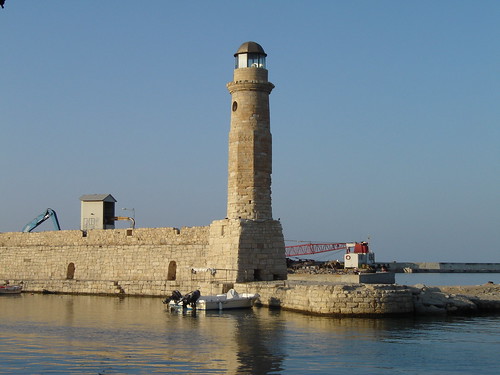
Rethymno (Greek: Ρέθυμνο, pronounced ['reθimno], also Rethimno, Rethymnon, Réthymnon, and Rhíthymnos) is a city of approximately 40,000 people in Greece, the capital of Rethymno Prefecture in the island of Crete. It was built in antiquity (ancient Rhithymna and Arsinoe), even though was never a competitive Minoan center. It was, however, strong enough to mint its own coins and maintain urban growth. One of these coins is today depicted as the crest of the town with two dolphins in a circle.
This region as a whole is rich with ancient history, most notably through the Minoan civilisation centred at Kydonia east of Rethymno.
Rethymno itself began a period of growth when the Venetian conquerors of the island decided to put an intermediate commercial station between Heraklion and Chania, acquiring its own bishop and nobility in the process. Today's old town (palia poli) is almost entirely built by Venetians. It is one of the best preserved old towns in Crete.
The town still maintains its old aristocratic appearance, with its buildings dating from the 16th century, arched doorways, stone staircases, Byzantine and Hellenic-Roman remains, small Venetian harbor and narrow streets. The Venetian Loggia today houses the information office of the ministry of culture. The Wine Festival is held there annually at the beginning of July. Another festival is held on 7-8th of November, in memory of the destruction of Arkadi Monastery.
It has a large Venetian castle called the Fortezza, one of the best preserved castles in Crete. Other monuments include the Neratze mosque (the Municipal Odeon arts centre), the Great Gate (megali porta, Porta Guora), the Piazza Rimondi (Rimondi square) and the Venetian Loggia.
As part of the Crete, the town was also captured by Turks in 1600s and ruled more than 3 centuries. Turkish version of Rethymnon is Resmo. It was sanjak centre in Crete (Girit) Province during Ottoman rule.
Today its main income is from tourism, many new facilities having been built in the past 20 years. Agriculture is also notable, especially for olive oil and other Mediterranean products. It is also the base of the Philosophical School and the University Library of the University of Crete and the School of Social and Political Sciences having 8000 students on its University Campus per annum at "Galos", where the Academic Institute of Mediterranean Studies is situated. The city has an Archaeological Museum.
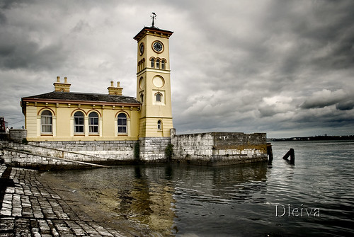
Cobh (pronounced /ˈkoʊv/; Irish: An Cóbh, "cove") is a sheltered seaport town on the south coast of County Cork, Ireland with a approx population of around 28,639.
The locality, which had had several different Irish-language names, was first referred to as Cove ("The Cove of Cork") in 1750. It was renamed Queenstown in 1849 to commemorate a visit by Queen Victoria and so remained until the name Cobh (closer to the Irish spelling) was restored in 1922 with the foundation of the Irish Free State.
Cobh is located on the south shore of the Great Island in Cork Harbour, (reputed to be the second largest natural harbour in the world), on south-facing slopes overlooking the entrance to the harbour. Facing the town of Cobh are Spike Island and Haulbowline Island. On a high point in the town stands the Cobh Cathedral, St. Colman's, seat of the diocese of Cloyne.
Puerto José Banús, more commonly known as Puerto Banús is a marina in Marbella, Spain on the Costa del Sol. It was built in 1970 by José Banús, a local property developer, as a luxury marina and shopping complex for the jet-set and the super rich.
The lavish opening of the complex in May 1970 was attended by, amongst others, the Aga Khan, film director Roman Polanski, Playboy founder Hugh Hefner, Dr. Christian Barnard (pioneer of the heart transplant), and Prince Rainier and Princess Grace of Monaco. A youthful Julio Iglesias was contracted to sing for the guests for the enormous sum of 125,000 pesetas. An army of 300 waiters from Seville served 50 pounds of beluga caviar to the 1,700 guests.
The focal point of Puerto Banus is the marina. It has berths for 915 boats, including those of the King of Saudi Arabia and several of the world's wealthiest individuals. Behind the harbour lie streets filled with bars, boutiques and nightclubs.
The marina has slips for boats and ships from 8 to 50 meters. Its surface area is 15 hectares, and its depth ranges from 3 to 6 meters within the marina, with 7.5 meters at its entrance. There is beach on each side of the marina. Many of the yachts moored within can enjoy an unobstructed view of La Concha mountain, one of the coast's landmarks.
José Banús himself was a developer with real estate holdings all along the coast. He was an intimate of Francisco Franco's and was called el constructor del régimen ("the regime's builder").
A three-ton statue of a rhinoceros by Salvador Dalí was placed in Puerto Banús in 2004. Officially known as Rinoceronte vestido con puntillas ("Rhinoceros dressed in lace"), Dalí created the sculpture in 1956 following the filming of his surrealist movie La aventura prodigiosa de la encajera y el rinoceronte ("The prodigious adventure of the lacemaker and the rhinoceros") in 1954.
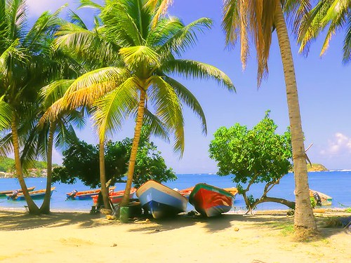
travelMartinique is an island in the eastern Caribbean Sea, with a land area of 1,128 km2 (436 sq mi). It is an overseas region of France, consisting of a single overseas department. To the northwest lies Dominica, to the south St Lucia, and to the southeast Barbados. As with the other overseas departments, Martinique is one of the twenty-six regions of France (being an overseas region) and an integral part of the Republic.
As part of France, Martinique is part of the European Union, and its currency is the euro. Its official language is French, although many of its inhabitants also speak Antillean Creole (Créole Martiniquais). Martinique is pictured on all euro banknotes, on the reverse at the bottom of each note, right of the Greek ΕΥΡΩ (EURO) next to the denomination.
travel Diamond Rock (Rocher du Diamant) is a 175 meter (574 feet) high basalt island located south of Fort-de-France, the main port of the Caribbean island of Martinique.
The uninhabited island is about three kilometers from Pointe Diamant. The island gets its name from the reflections that its sides cast at certain hours of the day, which evoke images of a precious stone. Its claim to fame is the role that it played in the Napoleonic Wars.
The rock is a volcanic plug, a remnant of the strong volcanic activity that affected the region some one million years ago.
However, a Captain Hansen of the Norwegian steamship Talsiman reported that on 13 May, 1902, he observed what he took to be a volcanic eruption from a hole in the rock. This was at the time of the devastating volcanic eruption Mount Pelée that destroyed Saint-Pierre. Hansen did not investigate further.
Like the other 47 islets that circle Martinique, the Rock has its own ecological characteristics. It is sunnier than the main island, drier, and subject to a long seasonal dry period. Today it is covered in undergrowth and cacti.
Relatively inaccessible and inhospitable, the island is uninhabited, which has permitted it to remain a sanctuary for a species that had been believed to be extinct.
A nature survey has suggested that Diamond Rock is probably the last refuge for a species of reptile once endemic to Martinique, the Couress grass snake (Liophis cursor).
Below water the Diamond Rock cavern, a deep triangular cave, is a popular attraction for scuba divers. The cave is said to contain prolific quantities of beautiful sea fans and corals, though strong currents make diving the island a risky venture.
The author John Fine reports that while diving he found one of the Rock's cannon that the French had toppled from the summit.
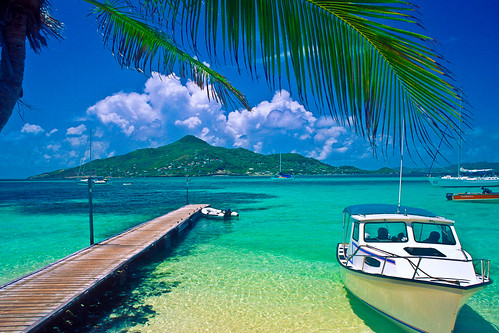
travel Petit St. Vincent, known locally as PSV, is an island 40 statute miles (60 km) south of St. Vincent in the Grenadine islands. It consists of softly rolling hills spread over 113 acres (46 ha) surrounded mostly by two miles (3 km) of white sand beaches.
The island is privately owned. In the 1960s, friends Hazen Richardson and Douglas Terman discovered the island while sailing, and conceived the idea of making it an exclusive resort. Richardson oversaw the construction of the resort and operated it for 40 years; Terman went on to become a novelist.
PSV consists of 22 cottages and a central dining room, with staff housing and other support structures. It is a resort for a particular kind of person; the cottages are not air-conditioned, and have neither televisions nor telephones. However, the food, service, and other amenities are of a very high quality. Guests can take all meals in their cottages, and are otherwise guaranteed total privacy should they wish it.
Owner Haze Richardson died in a swimming accident in Costa Rica on Saturday February 2, 2008. His wife, Lynn Richardson, plans to continue managing the resort.
http://www.psvresort.com
travel Ghazanchetsots Cathedral (Armenian: Սուրբ Ամենափրկիչ Ղազանչեցոց Եկեղեցի), also known as the Cathedral of Christ the Savior and the Shushi Cathedral, is an Armenian church located in Shushi, Nagorno-Karabakh. It was built between 1868 and 1887 and has a facade of white limestone. Its architect, Simon Ter-Hakobyan, intended the church to resemble Etchmiadzin Cathedral. In front of the west entrance is a freestanding three-story bell tower, constructed in 1858. Large statues of angels blowing trumpets stood at each corner of the bell tower's second story. However, they were destroyed during the Nagorno-Karabakh War when Shushi was under Azeri control.
The cathedral has seen a number of uses over the years. Its use as a functioning church ended after the Shusha pogrom of 1920. During the Soviet period period it was used as a granary, and then as a garage. During the Nagorno-Karabakh War, Azerbaijani forces used the cathedral as a GRAD munitions storehouse until May 1992, when Shushi was captured by Armenian forces. In the years after that capture the church was repaired and renovated. Replica angel statues were made to replace the destroyed originals; an image of one forms part of the coat-of-arms of Shushi. In 1998 it was re-consecrated as a church, and it is the main cathedral and headquarters of the Armenian Apostolic Church's Diocese of Artsakh.
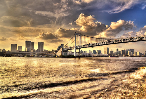
travelTokyo Bay (東京湾 Tōkyō-wan?) is a bay in the southern Kantō region of Japan. Its old name was Edo Bay (江戸湾 Edo-wan?).
Tokyo Bay is surrounded by the Boso Peninsula (Chiba Prefecture) to the east and the Miura Peninsula (Kanagawa Prefecture) to the west. In a narrow sense, Tokyo Bay is the area north of the straight line formed by the Cape Kannon (観音崎 Kannon-zaki?) on the Miura Peninsula on one end and Cape Futtsu (富津岬 Futtsu-misaki?) on the Boso Peninsula on the other end. This area covers about 922 km². Tokyo Bay in a broad sense includes also the Uraga Channel. The total area would then be 1320 km².
Tokyo Bay includes about 249 km² of reclaimed land area.
The only natural island in the Bay is Monkey Island (猿島 Saru-shima?), Yokosuka, Kanagawa. There are however many artificial islands that were built as naval fortification during the Meiji and Taishō period.
[edit]Islands
Dream Island (Yume No Shima)
Odaiba
Saru Island (the only natural one)
Heiwa Island ja:平和島
Katsushima ja:勝島
Showa Island ja:昭和島
Keihin Island ja:京浜島
Hakkeijima
Higashi Ogijima ja:東扇島
Tokyo International Airport
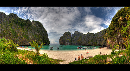
travel Ko Phi Phi Leh (or Ko Phi Phi Ley) is an island of the Phi Phi archipelago, in the Andaman Sea. It belongs to the Krabi province of Thailand.
Mahya Bay (or Maya Bay) is popular for diving, and has become even more popular after the 2000 movie The Beach was filmed there. According to the Lonely Planet's Thailand guidebook, the 2004 tsunami dramatically improved the look of Maya Bay. This was due to the fact that the high waves had cleaned up the beach and removed all the landscaping the Fox production team had added.
Controversy arose during the making of the film The Beach due to 20th Century Fox bulldozing and rescaping of the natural beach setting of Ko Phi Phi Leh to make it more "paradise-like". The production altered some sand dunes and cleared some coconut trees and grass to widen the beach. Fox set aside a fund to reconstruct and return the beach to its natural state, however lawsuits were filed as many believed the damage to the ecosystem is permanent and restoration attempts failed.
The lawsuits dragged on for years. In 2006, Thailand's Supreme Court upheld an appeal court ruling that the filming had harmed the environment and ordered that damage assessments be made. Defendants in the case included 20th Century Fox and some Thai government officials.
Prior to 2004, the island had avoided development. However, it is now a part of Phi Phi National Park and has since begun to see the beginnings of development and some clearing of natural plant life. There are current plans to build bungalows on the island and as of 2004 an entry-fee of 40 Baht has been charged; as of February 2007 the charge for private visitors has been raised to Bt200 per person. There are now permanent basic facilities on the island - toilets, a snack bar and camping sites.
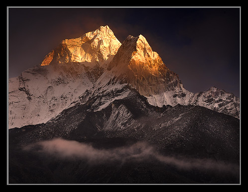
travel Ama Dablam is a mountain in the Himalaya range of eastern Nepal. The main peak is 6,812 metres (22,349 ft), the lower western peak is 5,563 metres (18,251 ft). Ama Dablam means "Mother's necklace"; the long ridges on each side like the arms of a mother (ama) protecting her child, and the hanging glacier thought of as the dablam, the traditional double-pendant containing pictures of the gods, worn by Sherpa women. For several days, Ama Dablam dominates the eastern sky for anyone trekking to Mount Everest basecamp.
Ama Dablam was first climbed on March 13, 1961 by Mike Gill (NZ), Barry Bishop (USA), Mike Ward (UK) and Wally Romanes (NZ) via the Southwest Ridge. They were well-acclimated to altitude, having wintered over at 5800 meters near the base of the peak as part of the Silver Hut Scientific Expedition of 1960-61, led by Sir Edmund Hillary.
Ama Dablam is the third most popular Himalayan peak for permitted expeditions. The most popular route by far is the Southwest Ridge (right skyline in the photo).
Climbers typically set up three camps along the ridge with camp 3 just below and to the right of the hanging glacier, the Dablam. Any ice that calves off the glacier typically goes left, away from the camp. However, a 2006 avalanche proved otherwise.
A climbing permit and a liaison officer are required when attempting Ama Dablam. As with Mt. Everest, the best climbing months are April-May (before the monsoon) and September-October.
travel The Rideau Canal (French: Canal Rideau), also known as the Rideau Waterway, connects the city of Ottawa, Ontario, Canada on the Ottawa River to the city of Kingston, Ontario on Lake Ontario. The canal was opened in 1832 as a precaution in case of war with the United States and is still in use today, with most of its original structures intact.
The canal system uses sections of major rivers, including the Rideau and the Cataraqui, as well as some lakes. It is the oldest continuously operated canal system in North America, and in 2007, it was registered as a UNESCO World Heritage Site.
It is operated today by Parks Canada as a recreational waterway. The locks on the system open for navigation in mid-May and close in mid-October.
travel







Nuremberg Castle: the three castles that tower over the city including central burgraves' castle, with Free Reich's buildings to the east, the Imperial castle to the west.
Heilig-Geist-Spital. In the centre of the city, on the bank of the river Pegnitz, stands the Hospital of the Holy Spirit. Founded in 1332, this is one of the largest hospitals of the Middle Ages. Lepers were kept here at some distance from the other patients. It now houses elderly persons and a restaurant.
Hauptmarkt, which provides a picturesque setting and famous market for gingerbread. Nuremberg's star attraction is the Gothic Schöner Brunnen (Beautiful Fountain) which was erected around 1385 but subsequently replaced with a replica (the original fountain is kept in the Germanisches Nationalmuseum). The unchanged Renaissance bridge Fleischbrücke crosses the Pegnitz nearby.
The following churches are located inside the city walls: St. Sebaldus Church, St. Lorenz, Frauenkirche (Our Lady's Church), Saint Klara, Saint Martha, Saint Jakob, Saint Egidien, and Saint Elisabeth.
Gothic St Lorenz-Kirche (St. Lorenz church, St. Lorenz), one of the most important buildings in Nuremberg. The main body was built around 1270-1350.
The church of the former Katharinenkloster is preserved as a ruin, the charterhouse (Kartause) is integrated into the building of the Germanisches Nationalmuseum and the choir of the former Franziskanerkirche is part of a modern building.
The Walburga Chapel and the Romanesque Doppelkapelle (Chapel with two floors) are part of Nuremberg Castle.
The Johannisfriedhof is a medieval cemetery, containing many old graves (Albrecht Dürer, Willibald Pirckheimer, and others). The Rochusfriedhof or the Wöhrder Kirchhof are near the Old Town.
The Tiergarten Nürnberg is a zoo stretching over more than 60 ha in the Nürnberger Reichswald. It is the home of Flocke, an orphan polar bear cub who in 2008 became a major attraction and a figure of a large publicity campaign for Nuremberg's metropolitan region.
There is also a medieval market just inside the city walls, selling handcrafted goods.
The German National Railways Museum (German) (an Anchor Point of ERIH, The European Route of Industrial Heritage) is located in Nuremberg.
The Nuremberg Ring (now welded within an iron fence) is said to bring good luck to those that touch it.
The Nazi party rally grounds with the documentation-centre.