Tuesday, July 8, 2014

#Parga #Epirus, #western #Greece


In
antiquity the area was inhabited the Greek tribe of the Thesprotians. The
ancient town Toryne was probably located here.[3] The village of Parga stands
from the early 13th century. It was originally built on top of the mountain
"Pezovolo". In 1360 the Pargians in order to avoid the attacks of the
Magrebins transferred the village to its present location. During that period,
with the help of the Normans who held the island of Corfu, the fortress of
Parga was built. In 1401 a treaty was signed with the Venetians, and the rule
of Ionian Islands passed to them. The Venetians respected the lifestyle of
Pargians who provided in turn, invaluable assistance to the fleet of the
Venetians. At the same time Pargians fought by the side of their compatriots to
throw off Ottoman rule. As Parga was the only free Christian village of Epirus,
it was a perfect refuge for persecuted fighters and their families. In 1797 the
area, along with the Ionian Islands and Parga, fell into the hands of the
French, and in 1800 proclaimed free city status with broad authority under the
protection of the Sublime Porte. In 1815, with the fortunes of the French
failing, the citizens of Parga revolted against French rule and sought the
protection of the British.
In 1817,
following a treaty between Britain and the Ottoman Empire, the British granted
Parga to the Ottomans. This resulted in the Good Friday of 1819 where 4,000
Pargians having with them the ashes of the bones of their ancestors, their
sacred images, flags and a handful of soil from their homeland, exiled
themselves in the British protecturate of Corfu where they settled. The former
citizens of Parga never ceased to dream of returning to a free country and to
participate actively in the struggle for liberation. But they had to wait
almost 100 years for this. Parga and the rest of Epirus was liberated from the
Ottoman rule on 1913 following the victory of Greece in the Balkan Wars.
From
Wikipedia, the free encyclopedia

'via Blog this'


"A journey of a thousand miles must begin with a single step." -- Lao Tzu Copyright © Demetrios the Traveler

Eltz Castle, Moselle River, between Koblenz and Trier, Germany.


Website : www.burg-eltz.de
Eltz Castle
(German: Burg Eltz) is a medieval castle nestled in the hills above the Moselle
River between Koblenz and Trier, Germany. It is still owned by a branch of the
same family that lived there in the 12th century, 33 generations ago. The
Rübenach and Rodendorf families' homes in the castle are open to the public,
while the Kempenich branch of the family uses the other third of the castle.
The Palace of Bürresheim (Schloss Bürresheim), the Castle of Eltz and the
Castle of Lissingen are the only castles on the left bank of the Rhine in
Rhineland-Palatinate which have never been destroyed.
The castle
is a so-called Ganerbenburg, or castle belonging to a community of joint heirs.
This is a castle divided into several parts, which belong to different families
or different branches of a family; this usually occurs when multiple owners of
one or more territories jointly build a castle to house themselves. Only a very
rich medieval European lord could afford to build a castle on his land; many of
them only owned one village, or even only a part of a village. This was an
insufficient base to afford a castle. Such lords lived in a knight's house,
which was a simple house, scarcely bigger than those of his tenants. In some
parts of the Holy Roman Empire of the German Nation, inheritance law required
that the estate be divided between all successors. These successors, each of
whose individual inheritance was too small to build a castle of his own, could
build a castle together, where each owned one separate part for housing and all
of them together shared the defensive fortification. In the case of Eltz, the
family comprised three branches and the existing castle was enhanced with three
separate complexes of buildings.
The main
part of the castle consists of the family portions. At up to eight stories,
these eight towers reach heights of between 30 and 40 meters. They are
fortified with strong exterior walls; to the yard they present a partial
framework. About 100 members of the owners' families lived in the over 100
rooms of the castle.
Platteltz,
a Romanesque keep, is the oldest part of the castle. In 1472 the Rübenach
house, built in the Late Gothic style, was completed. Remarkable are the
Rübenach Lower Hall, a living room, and the Rübenach bedchamber with its
opulently decorated walls.
Between
1490 and 1540, the Rodendorf house was constructed, also in Late Gothic style.
It contains the vaulted "banner-room".
The
Kempenich houses were finished about 1530. Every room of this part of the
castle could be heated; in contrast, other castles might only have one or two
heated rooms. From 1965 to 1992, an engraving of Eltz Castle was used on the
German 500 Deutsche Mark note.

From
Wikipedia, the free encyclopedia


'via Blog this'

"A journey of a thousand miles must begin with a single step." -- Lao Tzu Copyright © Demetrios the Traveler
Friday, May 16, 2014

"Visit Greece" featuring Alkistis Protopsalti (Greek)


"A journey of a thousand miles must begin with a single step." -- Lao Tzu Copyright © Demetrios the Traveler

Friday, April 25, 2014

Greek Tourism. An eternal journey!


Tourism. Greece's oldest industry... an industry of dreams. 
1914. The 1st National Tourism Organization.
Greece's fame spreads around the world!!!
10.000 tourists in 1914
17,5 million in 2014
Greece, a small piece of heaven on earth.

http://www.visitgreece.gr
Directed Script: Andonis Theocharis Kioukas 
Produced: QKas productions 
Text: Donald Morgan Nielsen
Music: ©Dimitris Papadimitriou 


"A journey of a thousand miles must begin with a single step." -- Lao Tzu Copyright © Demetrios the Traveler

Saturday, March 22, 2014

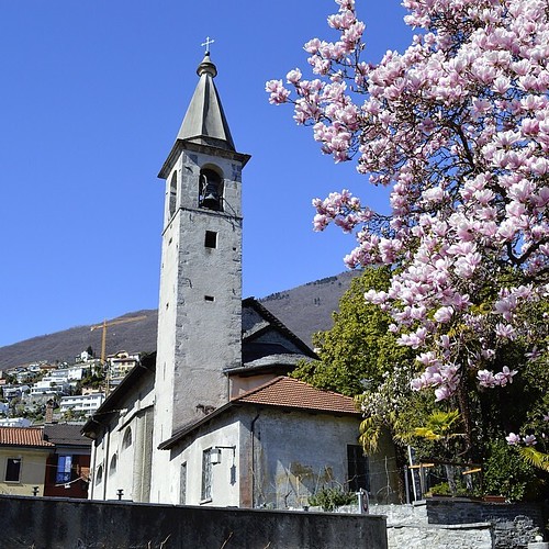
Locarno, Canton of Ticino, CH

There are nine Swiss heritage site of national significance in Locarno. Three of the sites are churches; the church of S. Francesco and former convent, the church of S. Maria Assunta (new church) and house of the canons and the church of S. Maria in Selva with Cemetery. The Castello Visconteo complex (part of which may have been designed by Leonardo da Vinci) is on the list. Two schools, the Ai Saleggi primary school and the Secondary School at via Dr. G. Varesi 30, as well as the Cantonal Library are also listed. The last two are the Pinacoteca comunale Casa Rusca at piazza Sant’Antonio and the Casorella at Via Bartolomeo Rusca 5 make up the rest of the list. The entire city of Locarno is listed on the Inventory of Swiss Heritage Site

Temple of Hephaistos in the Ancient Agora of Athens, Greece

The Temple of Hephaestus, also known as the Hephaisteion or earlier as the Theseion, is a well-preserved Greek temple; it remains standing largely as built. It is a Doric peripteral temple, and is located at the north-west side of the Agora of Athens, on top of the Agoraios Kolonos hill. From the 7th century until 1834, it served as the Greek Orthodox church of St. George Akamates.
Hephaestus was the patron god of metal working and craftsmanship. There were numerous potters' workshops and metal-working shops in the vicinity of the temple, as befits the temple's honoree. Archaeological evidence suggests that there was no earlier building on the site except for a small sanctuary that was burned when the Persians occupied Athens in 480 BC. The name Theseion or Temple of Theseus was attributed to the monument under the assumption it housed the remains of the Athenian hero Theseus, brought back to the city from the island of Skyros by Kimon in 475 BC, but refuted after inscriptions from within the temple associated it firmly with Hephaestus.

Construction

After the battle of Plataea, the Greeks swore never to rebuild their sanctuaries destroyed by the Persians during their invasion of Greece, but to leave them in ruins, as a perpetual reminder of the war. The Athenians directed their funds towards rebuilding their economy and strengthening their influence in the Delian League. When Pericles came to power, he envisioned a grand plan for transforming Athens into the centre of Greek power and culture. Construction started in 449 BC, and some scholars believe the building not to have been completed for some three decades, funds and workers having been redirected towards the Parthenon. The western frieze was completed between 445-440 BC, while the eastern frieze, the western pediment and several changes in the building's interior are dated by these scholars to 435-430 BC, largely on stylistic grounds. It was only during the Peace of Nicias (421-415 BC) that the roof was completed and the cult images were installed. The temple was officially inaugurated in 416-415 BC.

Saturday, March 8, 2014

Fraserburgh, Scotland, GB


Storm 14-14 [Explored], originally uploaded by linlaw39.

The town has had a local lifeboat on service since 1806 which was run privately by the local Harbour Board until the first RNLI operated station opened in 1858. This was the first official RNLI station opened in Scotland. Throughout the 20th century, Fraserburgh suffered three lifeboat disasters. First, in 1918, the 'Lady Rothes' capsized while assisting H.M. Drifter Eminent. Coxswain Andrew Noble and Acting Second Coxswain Andrew Faquhar drowned. Second, on the 9th February 1953, six crew members lost their lives when the lifeboat capsized while escorting fishing vessels to the harbour. On this occasion Coxswain Andrew Ritchie, Mechanic George Duthie, Bowman Charles Tait, Assistant Mechanic James Noble and Crew Members John Crawford and John Buchan all lost their lives - the only survivor was Charles Tait. Lastly, on 21 January 1970 while on service to the Danish fishing vessel Opal, the lifeboat The Duchess of Kent capsized with the loss of five of her crew of six. Those killed were Coxswain John Stephen, Mechanic Frederick Kirkness and Crew Members William Hadden, James RS Buchan and James Buchan.[6] In 2009, a local campaign was started to raise £40,000 to erect an official monument to the 14 men who lost their lives whilst serving on the Fraserburgh Lifeboat. Coxswain Victor Sutherland announced in June 2010 that the total had been achieved. The monument was unveiled by Flora Fraser, 21st Lady Saltoun, in August 2010 .

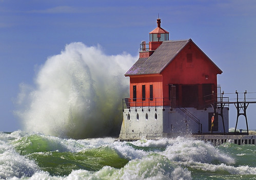
Grand Haven Lighthouse, Michigan, USA

A set of range lights built in 1905 to mark the entrance to the Grand River at Grand Haven, Michigan. The lights are set on a concrete breakwater extending into Lake Michigan on the south side of the river mouth. Because of the early importance of the Grand Haven harbor, a lighthouse was built here as early as 1839 Inner - A red, conical steel plate 51-foot tower fabricated by the American Bridge Company in 1905. The original Sixth Order Lens was given to the City and replaced by a plastic lens. The original Sixth Order lens was given to the City of Grand Haven when a plastic lens was installed.

Pierhead (outer) - is the original fog signal building built in 1875 which was moved to end of breakwater in 1905 after the pier had been extended several times. The red, wood frame structure was sheathed in corrugated iron in 1922.

The story-and-a-half building once housed the boilers to run the fog signal. It has a unique, massive concrete V-shaped front facing Lake Michigan, that is designed to protect the building from the fury of lake storms. This concrete gives the building the appearance of a ship's bow. The octagonal lantern is fitted with a plastic lens.

An elevated catwalk connects the two lights, but now stops short of running all the way to the beach. When the lights were manned by keepers, the catwalk was used to move from the shore in heavy weather.

The concrete breakwater is nice place to walk and fish, except when Lake Michigan is blowing. The buildings are not open to the public on these active aids to navigation. The U.S. Coast Guard Station-Grand Haven is responsible for maintaining this light and 15 lighthouses on the West Michigan lakeshore.

The lights are located at the end of South Harbor Drive in Grand Haven.

© Copyright 2010 John McCormick , All Rights Reserved.

Wednesday, February 26, 2014

Street at #Preveza, #Epirus #Greece


Greece - Street at Preveza, originally uploaded by massonth.

Today Preveza is a commercial harbour and tourist hub, with a marina, 4 Museums, two cinemas, an open theatre, a music Hall (OASIS), many clubs, taverns and cafes, benefiting from its proximity to the nearby Aktion National Airport and the nearby island of Lefkada, a major tourist destination. There are in the city University of Financial (TEI) and Commercial Navy Academy. The Aktio-Preveza Immersed Tunnel, opened on 2002, is an important work of infrastructure for what has traditionally been a remote and underdeveloped region, and links Preveza to Actium (Greek: Άκτιο, Aktio) on the southern shore of the Ambracian Gulf, greatly shortening the distance of the trip to Lefkada.

Greece Parga


Greece Parga, originally uploaded by massonth.

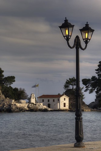
Parga and the surrounding areas have many restaurants and seaside taverns serving fresh fish and unique local recipes. The character of the city is lively and modern but also with intense elements of the past. Place for daily meetings is the main road in front of the port, where every evening you can enjoy the sunset, while the sun disappears in the Ionian Sea, between the Castle and the Island of Virgin Mary. The entertainment in Parga begins early in the morning and never stops. With idyllic walks and tours, with small stoned paths and traditional good food. Even when the daylight doesn’t reflect in the Ionian sea, Parga has many surprises for you and as long as the night is coming around the city reveals to you picturesque taverns by the sea or inside the small paths, tranquil and lounge places for your drink, but also and vigorous and entertaining rhythms for those who seek this kind of entertainment. In Parga and the wider region you could enjoy many sports, marine and other, since there are facilities for diving, water skiing, fishing, wind – surfing, hiking, bird watching, rafting, mountain biking, paragliding and horse riding.

Tuesday, February 25, 2014

Καρναβάλι Σοχού

Καρναβάλι Σοχού

Colours of #Kozani, #Macedonia #Greece


Colours of Kozani, originally uploaded by Faddoush.

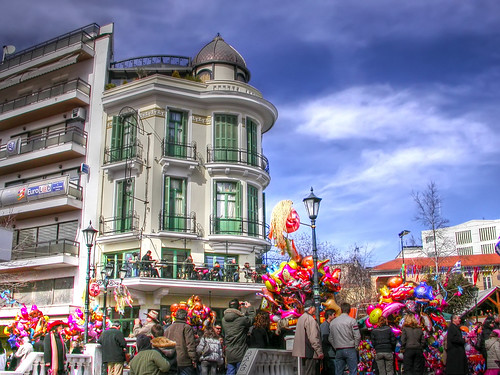
From our last trip to Kozani (city in Greece) during the carnivals, there were beautiful colours everywhere and it was a nice warm day.

#Greece

on the way to Spetsesgreek flagHydra portRio BridgeAre You Readyfluorescent Monastiraki
vacation mode is ONon the way to Porosrespectit is timeHydraunder the sun
stairway to heavenballoon1hot afternoonI wish I ...branchy snowfresh
Monastiraki and the blimpwinter 2008 on the way to Lesvoswinter 2008 arrivalaug 2004 athensakropolisGreece: Sea Sun & Culture

Greece, a set on Flickr.

a set on Flickr!

Glossa, #Messinia, #Peloponnese, #Greece


Messinia | Glossa, originally uploaded by Visit Greece.

Messinia: featuring luxurious resorts and boutique guest houses, high mountains and mellow olive groves, historical sites of all ages and of course amazing beaches of all kinds.

Τhis corner of the Peloponnese has it all!

Tuesday, February 11, 2014

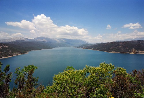
Υδροηλεκτρικός Σταθμός Πουρναρίου, Ποταμός Άραχθος, Τεχνητή λίμνη

Το φράγμα Πουρνάρι Ι βρίσκεται τεσσεράμισι χιλιόμετρα πάνω από την Άρτα και η κατασκευή του έγινε για τους εξής λόγους: Παραγωγή ηλεκτρικής ενέργειας στις αιχμές ενεργειακής ζήτησης, ανάσχαιση πλημμύρων ,ποθήκευση νερού για τις αρδευτικές ανάγκες του κάμπου.
Το φράγμα δόθηκε σε λειτουργία το 1981, έχει 450 μέτρα πλάτος στη βάση του, 580 μέτρα μέγιστο μήκος και 107 μέτρα ύψος. Αποτελεί το δεύτερο μεγαλύτερο φράγμα στην Ελλάδα (μετά από αυτό του Μούρνου) και συγκρατεί τα νερά του Άραχθου ελέγχοντας και τη ροή του ποταμού, ο οποίος και περνά μέσα από την ιστορική πόλη της Άρτας μερικά μόλις χιλιόμετρα νοτιοανατολικά.
Η λίμνη έχει επιφάνεια 18.3 τ.χλμ., μέγιστο μήκος τα 17.7 χλμ. και μέγιστο πλάτος τα 7.3 χλμ.
Επίσημες αναφορές για το βάθος της λίμνης δεν υπάρχουν και οποιαδήποτε υπόθεση θα μπορούσε να είναι λανθασμένη. Το υψόμετρο της λίμνης είναι περί τα 140 μέτρα.

Monday, February 10, 2014

Under the Bridge Downtown


Under the Bridge Downtown, originally uploaded by Jim Boud.
Underneath Old Sandridge Rail Bridge, Melbourne, Australia

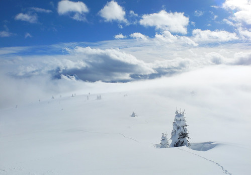
Dolomite winter


Dolomite winter, originally uploaded by bingleyman2.

Those trees are the tops of trees buried under 2 metres of snow. The tracks are animal tracks, snow impossible to walk on for mere humans.

Saturday, February 1, 2014

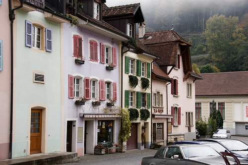
Saint Ursanne - Schweiz


Saint Ursanne - Schweiz, originally uploaded by jochan58.

Saint Ursanne (population approximately 1,000) is a city and a former municipality of the district of Porrentruy in the canton of Jura, Switzerland which has preserved its medieval character. The city contains many historical curiosities, including collegiate churches, a cloister, ruins of a castle, and a hermitage. The River Doubs makes a loop by Saint-Ursanne before flowing into France. Since 2009 Saint Ursanne is a part of the new municipality Clos du Doubs. Additionally, the city is famous for the medieval festival which it organizes each summer.
Its name refers to Saint Ursicinus, a seventh-century monk who built a monastery here.

Friday, January 31, 2014

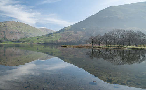
Brothers water, Lake District, Cumbria UK


Brotherswater, originally uploaded by bingleyman2.

Brothers Water is in the Hartsop valley and is a small lake in the eastern region of the English Lake District, in the county of Cumbria. Once called Broad Water, it lies at the northern end of Kirkstone Pass, affording picturesque views on the descent towards Patterdale.
Dorothy Wordsworth, having left William sitting on Cow Bridge, walked beside the lake on 16 April 1802, delighted with ‘...the boughs of the bare old trees, the simplicity of the mountains, and the exquisite beauty of the path...the gentle flowing of the stream, the glittering, lively lake, green fields without a living creature to be seen on them.’ The lake is not among the most popular of the National Park, being shallow and full of reeds. Water lilies bloom in July, providing colour.
The name Broad Water was changed in the 19th century after two brothers drowned there.
To the north east of Brothers Water is the village of Hartsop, which has several 17th-century stone farm buildings and cottages. Some of the buildings still contain spinning rooms where villagers would have made their own clothing, selling any surplus in the local market towns.
The word Hartsop means "valley of the deer", which would have lived in the woodlands of the lower areas of the surrounding fells.
A walk through woodland skirts the western shore.
From its northern end the walk leads to Patterdale. Southward it heads over Kirkstone Pass to Ambleside.
On the western side of Brothers Water is Hartsop Hall. The 16th-century building passed to Sir John Lowther in the 17th century. The village of Hartsop lies near the northeast corner of the lake. Brothers Water may be classified in either of two ways: as one of the Lake District's smallest lakes or one of its largest tarns.
The lake is home to a trout population and harbours a rare species of fish, the schelly.

Saturday, January 25, 2014

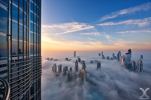
Cloud City


Cloud City, originally uploaded by DanielKHC.

“It’s so exciting to watch a big city look like a big jewel, with so many millions of lights shining on buildings nearby,” Daniel says. “You can spend the whole night shooting there — shooting wide, shooting with a tele[photo] lens or close to a building, etc.,” Daniel explains. “At the end of any rooftop session, you can walk away with hundreds of different shots, and it’s incredible.”

It helps that he isn’t afraid of heights. Daniel, however, does encounter dangerous and unpredictable situations on his shoots.

Old Town of Tallinn | From Toompea hill

Twisting cobblestone lanes and iron street lamps. Gothic spires and medieval markets. Cappuccino and Wi-Fi. This is the city's famous Old Town. If you're looking for that mix of historic ambience and cutting-edge culture that defines Tallinn, you'll find it here.

Built up from the 13th to 16th centuries, when Tallinn – or Reval as it was known then – was a thriving member of the Hanseatic trade league, this enclosed neighbourhood of colourful, gabled houses, half-hidden courtyards and grandiose churches is, quite rightly, the city's biggest tourist draw. And the fact that it's all neatly packaged within a mostly-intact city wall and dotted with guard towers gives it an extra dose of fairytale charm.

Tallinn Old Town is listed in the UNESCO World Heritage List. The aim of the 3d.tallinn.ee is to allow anyone interested in this Medieval pearl to access the Old Town by using 3D computing technology.
Read more and download the application from here.

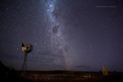
Milky Way


Milky Way, originally uploaded by john white photos.

The Milky Way is the galaxy that contains our Solar System. Its name "milky" is derived from its appearance as a dim glowing band arching across the night sky in which the naked eye cannot distinguish individual stars. The term "Milky Way" is a translation of the Latin via lactea, from the Greek γαλαξίας κύκλος (galaxías kýklos, "milky circle"). From the Earth, the Milky Way appears like a band because its disk-shaped structure is viewed from within the Galaxy. Galileo Galilei first resolved the band of light into individual stars with his telescope in 1610. In the past, astronomers thought that all of the stars in the universe were contained inside of the Milky Way. Following the 1920 Great Debate between the astronomers Harlow Shapley and Heber Curtis, observations by Edwin Hubble definitively showed that the Milky Way is just one of many galaxies.
The Milky Way is a barred spiral galaxy some 100,000–120,000 light-years in diameter which contains 100–400 billion stars. It may contain at least as many planets as well. The Solar System is located within the disk, about 27,000 light-years away from the Galactic Center, on the inner edge of a spiral-shaped concentration of gas and dust called the Orion–Cygnus Arm. The stars in the inner ≈10,000 light-years form a bulge and one or more bars that radiate from the bulge. The very center is marked by an intense radio source named Sagittarius A* which is likely to be a supermassive black hole.
Stars and gases at a wide range of distances from the Galactic center orbit at approximately 220 kilometers per second. The constant rotation speed contradicts the laws of Keplerian dynamics and suggests that much of the mass of the Milky Way does not emit or absorb electromagnetic radiation. This mass has been given the name "dark matter". The rotational period is about 240 million years at the position of the Sun. The Galaxy as a whole is moving at a velocity of approximately 600 km per second with respect to extragalactic frames of reference. The oldest known star in the Galaxy is at least 13.6 billion years old and thus must have formed shortly after the Big Bang. Surrounded by several smaller satellite galaxies, the Milky Way is part of the Local Group of galaxies, which forms a subcomponent of the Virgo Supercluster.

Kansas City, Missouri USA.


IMG_1273, originally uploaded by KingDavid73.

Downtown is the historic center of Kansas City, located entirely within Kansas City, Missouri, and containing the original town site, business districts and residential neighborhoods of the city. Downtown is bounded by the Missouri River on the north, the state line on the west, 31st Street on the south and the Blue River on the east. Downtown includes the central business district and its buildings which form the city's skyline. The downtown loop is formed by Interstates 670, 70, and 35. Within the downtown loop are many of the tall buildings and skyscrapers forming the city's skyline. Also within the downtown loop are small, distinct neighborhoods such as Quality Hill, the Garment District, the Financial District, the Convention Center District, and the Power and Light District.
Other neighborhoods within Downtown are the River Market and Columbus Park, both located between the downtown loop and the Missouri River. Between the downtown loop and the state line are Westside neighborhood and the West Bottoms, located at the bottom of the bluff adjacent to Kaw Point. East of the loop are the 18th & Vine District, the North Bottoms, East Bottoms, Northeast, and Pendleton Heights. South of the loop is the Crossroads District, Union Hill, Crown Center, Hospital Hill, Longfellow, Wendell Phillips, and Washington Wheatley.
The Kansas City Convention Center, Municipal Auditorium, City Hall, Lyric Theater, Midland Theater, Ilus Davis Park, and Barney Allis Plaza are located within the central business district inside the downtown loop. The Sprint Center and the College Basketball Experience are located within Power & Light District, also within the downtown loop. The Kauffman Center for the Performing Arts is perched upon a high point immediately south of the downtown loop. South of the loop is the Crossroads District, Union Station, Crown Center, the National World War I Museum, Liberty Memorial, Penn Valley Park, Truman Medical Center, Children's Mercy Hospital, and the 18th & Vine District. North of the loop are City Market within the River Market and Richard L. Berkeley Riverfront Park. West of the loop within the West Bottoms are Kemper Arena and Hale Arena.

Monday, January 20, 2014

Alex Thomson attempts the Keel Walk


O Alex Thomson κάνει τον stuntman και επιχειρεί αυτό που αποκαλεί "Ο περίπατος της καρίνας", ένα κατόρθωμα που έχει γίνει διαβόητο σε όλο τον κόσμο, χάρη στην εικόνα του Alex να «περπατά» με κοστούμι στην καρίνα του 20 μέτρων σκάφους του HUGO BOSS, που πλέει με ταχύτητα και μεγάλη κλίση. Το σκάφος είναι 8 τόνων φτιαγμένο από ανθρακονήματα.


"A journey of a thousand miles must begin with a single step." -- Lao Tzu Copyright © Demetrios the Traveler
Saturday, January 18, 2014

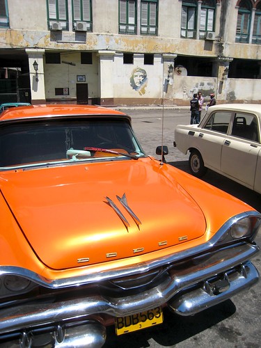
Yank tank, Cuba Orange


Cuba Orange, originally uploaded by @Doug88888.

Yank tank or máquina are the words used to describe the many classic cars (for example: 1957 Chevrolet, 1953 Ford, 1958 Dodge, etc.) present in Cuba with an estimated 60,000 of them still driving the roads today. In 1962 a United States embargo against Cuba was introduced, effectively cutting trade between the two countries. This meant that the cars in Cuba could no longer receive new replacement parts when something broke. Currently, the only way to keep these cars on the road today is by using Cuban ingenuity to adapt household products and Soviet technology into these vehicles. If a car is unable to be repaired at the time, the car is usually either “parked” for future repair or “parted out” (to produce extra income for the owner’s family) so that other cars can remain on the road. During the years of Soviet Union influence on Cuba, Ladas, Moskvitchs and Volgas became the main cars imported by the communist regime, mainly for state use. As a result of these internal economic restrictions, to this day there is no such thing as a new or used private European or Asian automotive dealership branch in Cuba for independent purchasing by regular Cubans.
Wednesday, January 8, 2014

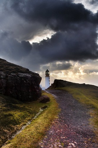
Rua Reidh Lighthouse

Built in 1912 by David A Stevenson, Rua Reidh Lighthouse, near Gairloch, stands at the entrance to Loch Ewe, at one of the most dramatic locations on the north-west coast of Scotland, with stunning views across the Minch to the Isle of Skye, the Shiant Isles and the Outer Hebrides.

It’s still a working lighthouse, but the original Lighthouse Keepers' Quarters are now privately owned and run as guest accommodation. We welcome our guests as we would our own family and friends – in a relaxed, sociable atmosphere where you can make yourself at home. You will have the companionship of other guests from around the world in our comfortable lounge and conservatory, and we invite our guests to join us for a home cooked supper in a friendly dinner party setting every evening.
We're at the end of a single track private road, three miles from the nearest house - you won't hear any traffic noise here, just the cries of the seabirds and the sound of the waves. If you love remote places, walking, wildlife, peace and solitude, it's an unforgettable, unique and unusual place to stay.

readers

labels and tags

Powered By Blogger