From Wikipedia, the free encyclopedia
Lisbon's public transport network is extremely far-reaching and reliable and has its metro as its main artery, connecting the city centre with the upper and eastern districts, and now reaching the suburbs. Ambitious expansion projects will increase the network by almost one third, connecting the airport, and the northern and western districts. Bus, funicular and tram services have been supplied by the Companhia de Carris de Ferro de Lisboa (Carris), for over a century.
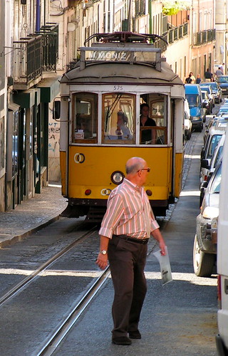
A traditional form of public transport in Lisbon is the tram. Originally introduced in the 19th century, the trams were originally imported from the USA and called americanos. The original trams can still be seen in the Museu da Carris (the Public Transport Museum) (Carris). Other than on the modern Line 15, the Lisbon tramway system still employs small (four wheel) vehicles of a design dating from the early part of the twentieth century. These distinctive yellow trams are one of the tourist icons of modern Lisbon, and their size is well suited to the steep hills and narrow streets of the central city.
There are other commuter bus services from the city: Vimeca, Rodoviaria de Lisboa, Transportes Sul do Tejo, Boa Viagem, Barraqueiro are the main ones, operating from different terminals in the city.
There are four commuter train lines departing from Lisbon: the Cascais, Sintra and Azambuja lines (operated by Comboios de Portugal (CP)), as well as a fourth line to Setúbal (operated by Fertagus) crossing the Tagus river over the 25 de Abril Bridge. A separate CP line to Setúbal ends at the southern bank of the Tagus and requires ferry transfer to reach Lisbon. The major railway stations are Santa Apolónia, Rossio, Gare do Oriente and Cais do Sodré.
The city does not offer a light rail service (tram line 15, although running with new and faster trams does not fall onto this category), but there are plans to build some lines with this service around the city (but not into the city itself).
The city is connected to the far side of the Tagus by two important bridges:
The 25 de Abril Bridge, inaugurated (as Ponte Salazar) on August 6, 1966, and later renamed after the date of the Carnation Revolution, was the longest suspension bridge in Europe. Because of its similar coloring, it is often compared to the Golden Gate Bridge in San Francisco, USA. In fact, it was built by the same company (American Bridge Company) that constructed the San Francisco-Oakland Bay Bridge and not the Golden Gate, also explaining its similarity in design to the former.
The Vasco da Gama Bridge, inaugurated on May 1998 is, at 17.2 km (10.7 mi), the longest bridge in Europe.
Another way of crossing the river is by taking the ferry. The company is Transtejo-Soflusa, which operates from different points in the city to Cacilhas, Seixal, Montijo, Porto Brandão and Trafaria under the brand Transtejo and to Barreiro under the brand Soflusa.
Lisbon is connected to its suburbs and the rest of Portugal by an extensive motorway network. There are three circular motorways around the city; the 2ª Circular, the CRIL and the CREL.
The Portela Airport is located within the city limits. TAP and Portugalia have their hubs here, and flights are available to Europe, Africa, and the Americas.
Sunday, October 31, 2010
Lisbon Portugal
Etna volcano, Sicily, Italy
[from wikipedia]
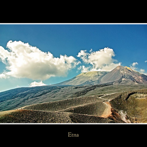
Mount Etna (Αἴτνη (Aítnē) in Classical Greek, Aetna in Latin, also known as Muncibeddu (beautiful mountain) in Sicilian and Mongibello in Italian (from the Latin mons and the Arabic gibel, both meaning mountain[3]) is an active stratovolcano on the east coast of Sicily, close to Messina and Catania. Its Arabic name was Jebel Utlamat ("the Mountain of Fire").
According to Adrian Room’s book Placenames of the World, the name Etna is said to have originated from a Phoenician word attuna meaning “furnace.” He dismisses the theory that Etna is from a Greek source meaning “I burn.”
It is the largest active volcano in Europe, currently standing 3,329 metres (10,922 ft) high, though this varies with summit eruptions; the mountain is 21 m (69 ft) lower now than it was in 1981. It is the highest mountain in Italy south of the Alps. Etna covers an area of 1,190 km² (460 sq mi) with a basal circumference of 140 km. This makes it by far the largest of the three active volcanoes in Italy, being about two and a half times the height of the next largest, Mount Vesuvius. Only Mount Teide in Tenerife surpasses it in the whole of the European region.
In Greek Mythology, the deadly monster Typhon was trapped under this mountain by Zeus, the god of the sky.
Mount Etna is one of the most active volcanoes in the world and is in an almost constant state of activity. The fertile volcanic soils support extensive agriculture, with vineyards and orchards spread across the lower slopes of the mountain and the broad Plain of Catania to the south.
Due to its history of recent activity and nearby population, Mount Etna has been designated a Decade Volcano by the United Nations.
La Seu, Palma, Majorca, Spain
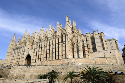
In 1901, fifty years after a restoration of the Cathedral had started, Antoni Gaudí was invited to take over the project. While some of his ideas were adopted - moving the choir stalls from the middle nave to be closer to the altar, as well as a large canopy - Gaudí abandoned his work in 1914 after an argument with the contractor. The planned changes were essentially cosmetic rather than structural, and the project was cancelled soon after.
source http://en.wikipedia.org/wiki/Palma_Cathedral
Friday, October 29, 2010
Waking up @ Matterhorn... Switzerland
The Matterhorn (German), Cervino (Italian) or Cervin (French), is a mountain in the Pennine Alps. With its 4,478 metres (14,692 ft) high summit, lying on the border between Switzerland and Italy, it is one of the highest peaks in the Alps and its 1,200 metres (3,937 ft) north face is one of the Great north faces of the Alps.
The individual pieces of the chocolate bar Toblerone are claimed by its maker Kraft to be formed in the likeness of the Matterhorn.
Zermatt (French: Praborgne) is a municipality in the district of Visp in the German-speaking section of the canton of Valais in Switzerland.
It is located at the northern base of the Matterhorn in the Pennine Alps, about 10 km from the border with Italy.
Zermatt has a permanent population of around 5,500 people, although the actual population varies considerably through the seasons as tourists come and go. The village is situated at the end of Mattertal, a north-facing valley, at an altitude of 1,620m (5,315ft). The valley is a dead end; although the border with Italy is close, it cannot be crossed by road, as it traverses a glacier at an altitude of over 3,000m. Zermatt is the starting point of the Patrouille des Glaciers and the Haute Route.
en.wikipedia.org/wiki/Matterhorn
en.wikipedia.org/wiki/Zermatt
Urmu Gölü - lake Urmia, IRAN
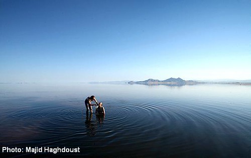
Urmu Gölü-lake urmia-اورمو گولو-دریاچه ارومیه-اورمیه-Urmiye-Orumiyeh, originally uploaded by urmuli.
The city lies on an altitude of 1,330 m above sea level on the Shahar Chaye river (City River). Urmia is the 10th populated city in iran and 2nd of Azerbaijanian Turks provinces after Tabriz. Urmia is the trade center for a fertile agricultural region where fruit (Specially Apple and Grape) and Tobacco are grown.
An important town by the 9th cent. Urmia was seized by the Oghuz Turks (11th cent.), sacked by the Seljuk Turks (1184), and later occupied a number of times by the Ottoman Turks.The name Urmia or Urmu is thought to have come from Sumerian tongue, the earliest known civilization in the world located in southern Mesopotamia. Ur was a principle Sumerian city. Some believe the name is derived from Syriac. Ur, meaning "cradle," and mia, meaning "water".
Hence, Urmia, situated by a lake and surrounded by rivers, would be the cradle of water.The population of Urmia is predominantly Azerbaijanian Turks (over 90%), but with Kurdish,Assyrian and Armenian minorities.
Tuesday, October 26, 2010
Zero Gravity Airplane Seating

While its garish yellow crocodile skin might not be your upholstery of choice (it was intended to be eye-catching at a recent exhibition), the Zero Gravity recliner is the latest in airplane seating and is one seriously comfy ride.
Created by B/E Aerospace, the Zero Gravity seat elevates your knees above your heart to increase circulation flow, reducing the risk of deep vein thrombosis. And the larger angle between your pelvis and back probably makes it more comfortable than even your bed at home. No word yet on which airline will introduce it first, although early-adopting passengers will most certainly have to pony up for a business- or first-class ticket to try it.
We like this a whole lot more than industry plans to test "standing seats."
Tuesday, October 19, 2010
HELMHAUS in Zurich Switzerland
HELMHAUS in Zurich Switzerland
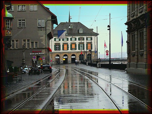
I took this for its reflection on the wet street
The houses to the left (guild house) and the right (town hall) date from approx. 1700
Most of the interesting sights are in the old town around the river and lakefront.
Grossmünster, Zwingliplatz, . Old Romanesque church, symbol of reformed Zurich, where reformer Huldrych Zwingli was appointed the people's priest in 1519. Tower 2CHF.
Fraumünster, Kämbelgasse 2, . Old Gothic church (former convent) with window paintings made by Marc Chagall.
Landesmuseum, Museumstrasse 2, ☎ +41 44 218 65 11, . Tu-Su 10AM-5PM and most public holidays including M. The biggest Swiss history museum. You can also learn about the various traditions of the cantons comprising Switzerland. It's currently undergoing major refurbishment works until 2009 though many exhibitions are still open.
Kunsthaus, ☎ +41 44 253 84 84, . One of the major Swiss art museums. Its specialities are modern sculpturer Giacometti and the surrealist 18th Century painter Fuseli, both Swiss. Entry is free to the main collection Wednesdays.
Schanzengraben. A small canal that used to be part of the city fortifications between Limmat and Sihl. From the main station, go to Gessnerallee, find the stairways down to the tiny creek, and walk all the way to the lake.
Rietberg Museum, Gablerstrasse 15, ☎ +41 (0)44 206 31 31, [20]. One of Europe's best collections of Asian art (mainly Indian drawings).
Langstrasse. Red light district of Zürich, with more drug dealers and police than usual, but interesting because even this most notorious spot in Switzerland is so clean and safe. The area is the most overtly multicultural spot of the town. In recent years, ateliers and stylish bars start to coexist side by side to the about 15 strip clubs.
Zoo, Zürichbergstrasse 221, ☎ +41 44 254 25 05, [21]. With the new Masoala Rainforest Hall, the Zoo is really worth a visit!
Lake Promenade. Especially during summer, the lake is a beautiful place to spend the evening or the weekend. Starting from Bellevue, the boardwalk goes for about three kilometers along the lake towards Tiefenbrunnen. About halfway from Bellevue there is a meadow where you will find thousands of people on a sunny day.
Chinese Garden, ☎ +41 44 435 21 11,. This small but beautiful Chinese garden was offered to the city of Zurich by the Chinese city of Kunming as symbol of gratitude after Zurich helped Kunming with technical knowledge.
Le Corbusier House, (near Chinese Garden),. A beautiful, modern villa planned by the famous Swiss architect. The visiting hours are very limited (i.e. one day / week only in the summer) and entry is expensive. Additionally, there is a legal battle between the city (owner) and the long time tenant.
Lindenhof. The hill in the heart of the old town. A beautiful view of the city and one time location of a Roman fort.
Niederdorf. The old town offers beautiful alleys, restaurants and shopping mainly aimed at younger consumers. In the evenings, people visit the Niederdorf's many bars.
Bahnhofstrasse. One of the busiest and best known shopping streets in the world. Highly refined. Certainly a must-see for every tourist in Zurich! (see below).
Museum Buehrle, Zollikerstrasse 172, ☎ +41 44 422 00 86, [24]. A rich private art collection worth visiting - although a little less rich after a recent brazen robbery in broad daylight. Call ahead, as it's currently not open during regular hours.
Jacob Coffee Museum, Seefeldquai 17, ☎ +41 44 388 61 51, [25]. An original museum which describes the evolution of coffee and different aspects of the culture that has developed around it.
Zurich West. This modern quarter used to be an industrial one, but modern urban developments made it into a center of vibrant night life.
source: http://wikitravel.org/en/Zurich
Tuesday, October 12, 2010
The Unseen Sea, SF, California USA
The Unseen Sea from Simon Christen on Vimeo.
A collection of time lapses I took around the San Francisco Bay Area roughly shot over the period of one year.
Please watch in HD Find more of my work on my website www.simonchristen.com or on my flickr account Music by Nick Cave - Mary's Song from the Soundtrack of "Assassination of Jesse James"Monday, October 11, 2010
The Internet Is Still Not For Everyone – woorkup.com

It radically changed the way we all interact and it has become the main medium of mass communication of our (if not all) time. Nevertheless it is used by just a few. How and why the Internet is still a technology available to less than 29% of the global population.
10 incredible Easter Island photos

10 incredible photos of the ancient Moai (man-made giants) which are scattered around Easter Island. Photographed by James Craig who visited the island in 2006 for a year. Easter Island is one of the most isolated places on earth, located 2,300 miles of the coast of Chile and 1,100 miles from Tahiti.
awesome!
Tuesday, October 5, 2010
readers
labels and tags
- #travel (1)
- 2011 solstice (1)
- ABU DHABI (1)
- Acadia (1)
- Acropolis (1)
- ACTION DAY (3)
- ADRIATIC SEA (1)
- adventure (1)
- ADVENTURES (45)
- AEGEAN (21)
- Aegean Sea (2)
- AFRICA (11)
- AGRA (1)
- agriculture (1)
- AIRLINERS (7)
- airplane (2)
- airplane seating (2)
- AIRPORTS (2)
- AIX EN PROVENCE (1)
- ALASKA (3)
- ALHAMBRA (1)
- ALICANTE (1)
- ALSACE (2)
- AMALFI (2)
- amazing (2)
- AMAZONIA (1)
- AMERICAS (113)
- AMORGOS (1)
- AMSTERDAM (3)
- Anafi (1)
- ancient greece (1)
- Ancient Greek language (2)
- ANDALUCIA (2)
- ANDES (2)
- angle (1)
- Anglo-Canadian (1)
- ANTARCTICA (3)
- ANTWERP (2)
- archipeelago (1)
- ARCHITECTURE WONDERS (86)
- ARCTIC (8)
- arctic ice (2)
- arctic ocean (1)
- ARGENTINA (3)
- ARGOS (1)
- Ariadnae (1)
- ARIZONA (2)
- articles (2)
- Artisanal olive oils (1)
- ASIA (95)
- ASIA MINOR (2)
- asklepios (1)
- ASPEN (1)
- ASTANA (1)
- astronomy (1)
- astrophotography (3)
- Athenian Democracy (2)
- ATHENS (23)
- ATHOS (2)
- ATLANTIC OCEAN (3)
- atmosphere (5)
- ATTIKI (3)
- AUCKLAND (1)
- aurora borealis (3)
- AUSTRALIA (7)
- AUSTRIA (4)
- autumn (2)
- Autumnal (1)
- AVEIRO (1)
- awesome (2)
- BAJA (1)
- BALI (3)
- BALLOONING (5)
- BALTIC STATES (1)
- BAMBERG (3)
- BARBADOS (2)
- BARCELONA (4)
- BARI (1)
- BAVARIA (2)
- bay area (1)
- beach getaway (1)
- BEACONS (2)
- beautiful destination (2)
- BEIJING (9)
- BELGIUM (5)
- BELIZE (1)
- BERLIN (2)
- BERNE (1)
- BHUTAN (1)
- BIG CITIES (16)
- BIRMINGHAM (1)
- BLED (1)
- blog (1)
- bloggers (1)
- BONIFACIO (2)
- BORA BORA (1)
- BORNEO (2)
- BOSTON (2)
- BOTANICAL (1)
- Bourbon str (1)
- BRAN (1)
- BRASOV (2)
- BRAZIL (2)
- BRETAGNE (2)
- BRIDGE (7)
- BRIGHTON (2)
- British (2)
- BRITISH COLUMBIA (1)
- BRITTANY (1)
- Bruges (1)
- BUCHAREST (1)
- BUDAPEST (2)
- BUDGET TOUR (9)
- BUENOS AIRES (1)
- BULGARIA (2)
- CALDERA (2)
- calendar (1)
- CALGARY (1)
- CALIFORNIA (7)
- CAMBODIA (1)
- CANADA (9)
- CANARY ISLES (3)
- CANNES (3)
- CAPE TOWN (2)
- CAPRI (1)
- cardpostal (1)
- CARIBBEAN ISLANDS (10)
- CARNIVAL (3)
- CASABLANCA (1)
- CASTELIFOLLIT DE LA ROCA (1)
- CASTLES (37)
- CAVES (2)
- CELEBRATIONS (2)
- CHALKIDIKI (2)
- CHANIA (2)
- Charlottetown (1)
- CHICAGO (1)
- CHILE (6)
- CHINA (23)
- christmas (1)
- civilization (2)
- climate change (2)
- COBH (1)
- COCHIN (1)
- COFFEE (3)
- Colmar (1)
- COLONE (2)
- COLORADO (2)
- comparison (1)
- CONEY ISLAND (1)
- Constanta (1)
- Constantinopole (1)
- COPENHAGEN (2)
- Corfu (1)
- CORNWAL (1)
- Cornwall (1)
- CORSICA (3)
- cosmos (2)
- COSTA DEL SOL (2)
- COTE D'AZUR (4)
- CRETE (7)
- CROATIA (1)
- CRUISE (12)
- cruise NEWS and BLOGS... (2)
- CUBA (2)
- CUENCA (1)
- Culinary (1)
- CULTURAL TOURS (67)
- culture (5)
- culure (1)
- Cyclades (1)
- CYPRUS (3)
- CZECH REPUBLIC (7)
- DAMASCUS (1)
- DANGEROUS PLACES (2)
- DARVAZ (1)
- DARWIN (4)
- december (1)
- declination (1)
- Delos (1)
- DELPHI (1)
- Democracy (1)
- demographic (1)
- DENALI(McKinley) (1)
- DENMARK (6)
- DESERT (7)
- design (1)
- DISNEYLAND Paris (1)
- DIVING (7)
- DOLOMITE (3)
- DOMINICAN REPUBLIC (1)
- DORDOGNE (1)
- DORSET (1)
- duba (1)
- DUBAI (8)
- DUBLIN (4)
- DUDLEY (1)
- DUSSELDORF (2)
- earth (2)
- earth hour (1)
- earth hour 2011 (1)
- Easter island (1)
- ECOTOUR (12)
- ECUADOR (1)
- EDINBURGH (1)
- EGESOV (1)
- ENDANGERED DESTINATIONS (1)
- environment (6)
- environmental (5)
- Epidaurus (1)
- EQUESTRIAN EVENT (1)
- ESA (1)
- estate (1)
- ESTONIA (1)
- ESTUARY (1)
- ETHIOPIA (1)
- ETNA (1)
- EUROPE (314)
- extra planetary TRAVEL (9)
- EZE (1)
- F1 TRAVELS (1)
- fairytale places (1)
- fall (1)
- famous (1)
- fantasy-like destination (1)
- FAR EAST (6)
- FERES (1)
- festival (1)
- FESTIVALS (10)
- FEZ (1)
- FINLAND (1)
- Flanders (1)
- FLORIDA (5)
- focus (1)
- foilage (1)
- FOLEGANDROS (2)
- FOLK ART (21)
- FOOD (21)
- FRANCE (38)
- FRANCONIA (2)
- FRANKFURT (2)
- French (3)
- FRENCH POLYNESIA (1)
- French Quarter (2)
- frequent fliers (1)
- FRISIA (1)
- GALWAY (1)
- Gardena Pass (1)
- GARDENS (1)
- GAVDOS (2)
- GENEVA (3)
- geography (1)
- GERMANY (27)
- GEYSIR (1)
- GLASGOW (1)
- Gloucester (1)
- google (1)
- Google Earth (1)
- gourmet (1)
- GRANADA (1)
- GRAND CANYON (1)
- GREECE (89)
- Greek art (1)
- GREEK ISLANDS (29)
- GREEK MAINLAND (6)
- GREENLAND (2)
- greetings (1)
- GREETSIEL (1)
- Grimaud (1)
- groves (1)
- Guangzhou (1)
- GUERNSEY (1)
- Halloween (1)
- HARLEM (1)
- HAWAII (3)
- hellas (1)
- Hellenistic art (2)
- HELMOS (1)
- HEREFORDSHIRE (1)
- heritage (1)
- HIGHLANDS (1)
- HIMALAYAS (2)
- HISTORIC TOUR (52)
- holidays (1)
- HONEYMOON (1)
- HONG KONG (4)
- HOTELS (24)
- HOUSTON (1)
- HUAN HI (1)
- HUNGARY (2)
- HYDRA (1)
- IBIZA (2)
- ICELAND (11)
- icescape (1)
- ILLINOIS (1)
- impresionist (1)
- INDIA (10)
- INDIAN OCEAN (4)
- INDONESIA (1)
- info-map (4)
- infographic (5)
- infographics (5)
- Infographics Artist (5)
- INNOVATIVE IDEAS (8)
- INNSBURG (1)
- IOANNINA (1)
- Ios (1)
- IRAN (2)
- ISLAS CALAPAGOS (1)
- ISLE OF EIGG (1)
- ISLE OF SKYE (1)
- islet (1)
- ISRAEL (1)
- ISTANBUL (2)
- ITALY (30)
- IZMIR (1)
- James Craig (1)
- JAPAN (9)
- jason de caires taylor (1)
- JERSEY (1)
- JOHANNESBURG (1)
- Juno (1)
- Jupiter (1)
- KARLOVY VARY (1)
- KARPATHOS (2)
- KAZAKHSTAN (1)
- KENT (1)
- KENTUCKY (1)
- KERALA (1)
- KIEV (1)
- Knossos (1)
- KOCHI (1)
- KOS (1)
- KOWLOON (1)
- KRUGER (1)
- KUWAIT (2)
- KYOTO (2)
- KYRGYZSTAN (1)
- LAHORE (1)
- LAKES (9)
- LAND TOUR (15)
- LandMark (42)
- LANGUAGE GUIDES (4)
- LANZAROTE (1)
- LAOS (1)
- LAS VEGAS (2)
- Latin (1)
- Latin language (1)
- LATVIA (1)
- LEEDS (1)
- LEICESTERSHIR (1)
- leisure (1)
- LICHTENSTEIN (2)
- LIFE TIME (64)
- lifetime (1)
- light (1)
- lighthouses (8)
- LIMASSOL (1)
- Lindos (1)
- LISBON (4)
- LITHUANIA (2)
- LIVERPOOL (1)
- LONDON (11)
- LOS ANGELES (1)
- LOUISIANA (1)
- Louvre (1)
- LUCERN (1)
- LUGANO (1)
- luxury resorts NEWS and BLOGS (8)
- MACEDONIA (1)
- Machu Picchu (1)
- MADEIRA ISLANDS (1)
- MADRID (1)
- magical places (1)
- MAGNA GRECIA (1)
- magnetic field (1)
- Maine (1)
- MALAGA (3)
- MALAYSIA (1)
- MALLORCA (2)
- MALTA (3)
- MANCHESTER (2)
- MANILA (1)
- MAPS (3)
- marina (1)
- Maritime (1)
- MARLOW (1)
- MARSEILLE (1)
- MARYLAND (1)
- MASSACHUSETTS (3)
- MED-diet (1)
- medieval festivals (1)
- Mediterranean (1)
- messinia (1)
- METEORA (2)
- MEXICO (4)
- MICHIGAN (1)
- MICRONATIONS (3)
- MID.EAST (11)
- MILAN (1)
- milky way (1)
- Milos (1)
- Moai (1)
- MONACO (3)
- monastery (1)
- Monet (1)
- MONGOLIA (3)
- MONTANA (1)
- MONUMENTS (4)
- MORROCO (1)
- MOSCOW (5)
- MOUNTAINS (13)
- MOVIES (3)
- MUNICH (6)
- museum (2)
- MUSEUMS (28)
- MYANMAR (1)
- Mycenae (1)
- MYCONOS (2)
- N. IRELAND (1)
- N.AMERICA (76)
- N.Carolina (1)
- Nagorno-karabakh (1)
- NAPLES (1)
- nasa (2)
- NASA Goddard (1)
- National Memorials (1)
- NATURAL WONDERS. (33)
- nature (2)
- NEPAL (2)
- neuchatel (1)
- NEVADA (2)
- NEW HAMPSHIRE (1)
- NEW MEXICO (2)
- NEW ORLEANS (1)
- new south wales (1)
- NEW YORK (20)
- NEW ZEALAND (1)
- NICE (3)
- NIGHT LIFE (6)
- NORMANDY (3)
- North Carolina (1)
- NORTH SEA (3)
- NORTH YORKSHIRE (1)
- NORTHEN TERRITORIES (2)
- northern lights (3)
- NORWAY (4)
- Nova Scotia (2)
- NUREMBERG (1)
- NYT travel (1)
- OAKLAND (1)
- OCEANIA (5)
- OLD TOWN (1)
- olives (1)
- Olympia (1)
- OLYMPIC VENUES (3)
- OMAN (2)
- one day on earth (1)
- OREGON (3)
- OTTAWA (1)
- oxford (1)
- PACIFIC ISLANDS (7)
- pacific ocean (2)
- paintings (1)
- PAKISTAN (2)
- PALMA de MALLORCA (2)
- PARGA (3)
- PARIS (15)
- PELOPONNESUS (5)
- PENA (1)
- PENNSYLVANIA (5)
- PERGAMOS.EPHESUS (1)
- PERU (3)
- Petit St. Vincent (1)
- phenomenon (2)
- PHI PHI (2)
- Philadelphia (1)
- PHILIPPINES (1)
- PHNOM PENH (1)
- photography (43)
- PHOTOS (377)
- PHUKET (1)
- pier (1)
- pigs (1)
- PIRAEUS (1)
- Pissaro (1)
- PITTSBURG (1)
- planet (1)
- PLOVDIV (1)
- poetry (1)
- POLAND (3)
- politcs (2)
- pontos (1)
- Portland (2)
- PORTUGAL (8)
- POTSDAM (1)
- PRAGUE (7)
- PRESENTATION (7)
- Private Islands (1)
- provinces (1)
- QUEBEC (2)
- RABAT (1)
- rainforest (1)
- RAINFOREST TRIBES (2)
- REPUBLIC of IRELAND (9)
- reutlingen (1)
- REYKJAVIK (2)
- RHEIN VALEY (1)
- RHODES (3)
- RIGA (1)
- RIVERS (5)
- ROMANIA (10)
- romantic destination (1)
- ROMANTIC TOUR (37)
- ROME (2)
- RONDA (1)
- Roseland peninsula (1)
- ruins (1)
- RUSSIA (5)
- S. America (2)
- S. KOREA (1)
- S.AFRICA (4)
- S.AMERICA (12)
- S.Dakota (1)
- S.LAWRENCE (1)
- SACRED PLACES (30)
- SAFARI's (1)
- sahara desert (2)
- Saint Paul de Vence (2)
- SALZBURG (2)
- SAMOS ISLAND (4)
- SAN ALFONSO DEL MAR (1)
- SAN FRANCISCO (3)
- SAN REMO (2)
- SAN TROPE (1)
- sanctuary (1)
- SANDANSKI (1)
- sandstorm (1)
- SANTORINI (9)
- SARLAT (1)
- saronic gulf (1)
- satellite (1)
- SAUDI ARABIA (1)
- SCHLESWIG-HOLSTEIN (1)
- SCOTLAND (15)
- SCUBA (1)
- sculpture (2)
- seacoast (3)
- SEASONAL (24)
- SEATTLE (2)
- SEX (2)
- SEYCHELLES (1)
- SHANGHAI (1)
- SHOWS (1)
- SIBIU (2)
- SICILY (1)
- SIERRA LA RANA (1)
- SIGHISOARA (1)
- SINGAPORE (2)
- SINTRA (1)
- SKI (6)
- SKOGAR (1)
- sky (2)
- skyline (1)
- SKYscraper (2)
- SLOVAKIA (1)
- SLOVENIA (2)
- social bookmarking (1)
- social media (1)
- Social networking (1)
- social travel (1)
- SOCOTRA (1)
- SOFIA (1)
- solstice (1)
- SOPA/PIPA (1)
- SOUNION (2)
- SPA (7)
- space (2)
- space age (2)
- space era (1)
- Space Shuttle (1)
- SPACE TRAVEL (18)
- spaceships (2)
- SPAIN (25)
- SPECIAL EVENT (39)
- SPORADES (2)
- ST. KILDA (1)
- ST.PETERSBURG (1)
- steppe (1)
- STOCKHOLM (3)
- Study (1)
- SUMATRA (1)
- summit (1)
- sun (3)
- sun activity (2)
- sunrise sunset (1)
- SWEDEN (4)
- SWITZERLAND (6)
- SYRIA (2)
- TALLINN (1)
- TED (1)
- TENNESSEE (1)
- Tenuta di Spannocchia (1)
- TEXAS (2)
- THAILAND (6)
- THAMES (1)
- the best of Mediterranean coast (1)
- THE NETHERLANDS (4)
- the silent evolution (1)
- THEME PARKS (6)
- THESSALONIKI (2)
- THESSALY (1)
- tilt-shift video (1)
- time lapse (4)
- TOKYO (1)
- tourism (3)
- tours (2)
- traditional music (20)
- TRAIN and LOCOMOTIVES (1)
- travel (14)
- TRAVEL ART (24)
- TRAVEL ARTICLE (3)
- TRAVEL BOOKS (4)
- Travel daily News (1)
- TRAVEL FUTURE (19)
- TRAVEL GEAR (8)
- TRAVEL HEALTH (4)
- TRAVEL HISTORY (21)
- TRAVEL HUMOR (14)
- TRAVEL POETRY (20)
- TRAVEL QUIZ (2)
- TRAVEL TIPS (41)
- Travel Utopia (53)
- travelling around (10)
- travelling around... (285)
- tribute (1)
- Trip Advisor (1)
- Tripl (1)
- TROPICAL (11)
- TROPICAL PARADISE (13)
- TToT (1)
- TURKEY (3)
- TUSCANY (3)
- U.A.E. (10)
- UK (45)
- UKRAINE (2)
- underwater (1)
- UNESCO heritage (1)
- univrse (1)
- unreal (2)
- upholstery (1)
- urban destination (9)
- URBAN DESTINATIONS (89)
- urbanism (3)
- urine (1)
- USA (76)
- utah (1)
- UZBEKISTAN (1)
- vacances (1)
- VACATIONS (17)
- VADUZ (1)
- VALENCIA (2)
- VALPARAISO (1)
- VANCOUVER (1)
- VANUATU (2)
- VATICAN STATE (1)
- Veni (1)
- VENICE (9)
- Venus de Milo (1)
- Verba Verti (1)
- Vergina (1)
- VERMONT (1)
- VICTORIA FALLS (2)
- VICTORIA HARBOUR (1)
- video (24)
- VIDEOS (79)
- Vidi (1)
- VIENNA (3)
- Villefranche-sur-Mer (1)
- VILNIUS (2)
- VINTAGE TRAVEL POSTERS (6)
- VIRGINIA (1)
- virtual tours (14)
- visit Greece (1)
- VOLCANO (3)
- WALES (1)
- WALKING TOURS (48)
- WASHINGTON_DC (2)
- WEIRDnews (11)
- WEIRDPLACES (63)
- wild places (2)
- XANTHI (1)
- yellow (1)
- YEMEN (1)
- ZANTE (1)
- ZARAGOZA (1)
- zero gravity (1)
- ZIMBABWE (1)
- zoo (1)
- ZURICH (2)
- ΑQUARIUM (2)
- Αγωνιστικη Λεσχη Καρπενησιου (1)
- Αθηνα (1)
- αμφιδρομη επικοινωνια (1)
- ασφαλτινο ραλλυ (1)
- αυξηση θερμοκρασιας (1)
- Δ. Κ. Γεωργαλας (1)
- διαδυκτιο (1)
- δικτυωση (1)
- εθνικος οργανισμος Τουρισμου (1)
- εκδηλωση (1)
- εκθεσεις (1)
- ελευθερια (1)
- Ελευθεροτυπια (1)
- Ελλαδα (4)
- επετειακο (1)
- Ευρυτανια (1)
- Ευρωπη (1)
- θαλασσα (1)
- ιστορια (1)
- Κ. Μπακογιάννης (2)
- Καρπενησι (2)
- Κερκυρα (1)
- κλιμα (1)
- κλιματικη αλλαγη (1)
- κοινωνικά δίκτυα (1)
- Κρητη (2)
- λιστα (1)
- νεοι ανθρωποι (1)
- νεος Δημος Καρπενησιου (2)
- παραθαλασσιοι (1)
- περιβαλλον (1)
- πολιτικη ιστορια (1)
- προορισμοι (1)
- ραλλυ σπριντ (1)
- Ροδος (1)
- Σαντορινη (1)
- τουρισμος (4)
- φιλελευθερισμος (1)
- φωτογραφια (1)
- Χριστουγεννα (1)
- ωρα (1)
- ωρα της ΓΗς (1)
