Wednesday, July 29, 2009

abstract of a trip

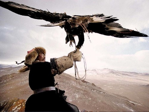
Mongolia is a landlocked country in East and Central Asia. It borders Russia to the north and the People's Republic of China to the south, east and west.
Although Mongolia does not share a border with Kazakhstan, its western-most point is only 24 miles (38 km) from Kazakhstan's eastern tip.
Ulan Bator, the capital and largest city, is home to about 38% of the population. Mongolia's political system is a parliamentary republic.
The area of what is now Mongolia has been ruled by various nomadic empires, including the Xiongnu, the Xianbei, the Rouran, the Gökturks, and others.
The Mongol Empire was founded by Genghis Khan in 1206. After the collapse of the Yuan Dynasty, the Mongols returned to their earlier patterns. In the 16th and 17th centuries, Mongolia came under the influence of Tibetan Buddhism.
At the end of the 17th century, most of Mongolia had been incorporated into the area ruled by the Qing Dynasty. During the collapse of the Qing Dynasty in 1911, Mongolia declared independence, but had to struggle until 1921 to firmly establish de-facto independence, and until 1945 to gain international recognition.
As a consequence, it came under strong Russian and Soviet influence: In 1924, the Mongolian People's Republic was declared, and Mongolian politics began to follow the same patterns as Soviet politics of the time.
After the breakdown of communist regimes in Eastern Europe in late 1989, Mongolia saw its own Democratic Revolution in early 1990, which led to a multi-party system, a new constitution in 1992, and the - rather rough - transition to a market economy.
At 1,564,116 square kilometres, Mongolia is the nineteenth largest and the most sparsely populated independent country in the world, with a population of around 2.9 million people. It is also the world's second-largest landlocked country after Kazakhstan.
The country contains very little arable land, as much of its area is covered by steppes, with mountains to the north and west and the Gobi Desert to the south. Approximately 30% of the country's 2.9 million people are nomadic or semi-nomadic.
The predominant religion in Mongolia is Tibetan Buddhism, and the majority of the state's citizens are of the Mongol ethnicity, though Kazakhs, Tuvans and other minorities also live in the country, especially in the west. About 20% of the population live off less than US$ 1.25 a day.


"A journey of a thousand miles must begin with a single step." -- Lao Tzu
Copyright © Demetrios the Traveler

Digg!


Thursday, July 23, 2009

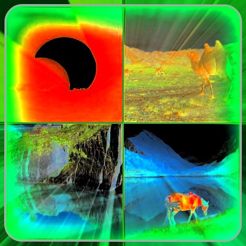
eclipse fantasy!

just to say a hello to you all...see you in few days!


"A journey of a thousand miles must begin with a single step." -- Lao Tzu
Copyright © Demetrios the Traveler


Digg!


Monday, July 20, 2009

Mongólía


Mongólía, originally uploaded by Emilavatar.
vacation Mode is ON

see you in few days

"A journey of a thousand miles must begin with a single step." -- Lao Tzu
Copyright © Demetrios the Traveler


Digg!


Wednesday, July 15, 2009

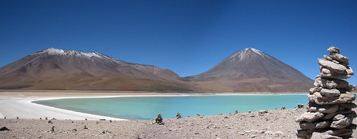
Atakama desert, Chile


Atakama desert, originally uploaded by robmcm.
Lakes in the Atakama desert


The Atacama Desert is a virtually rainless plateau in South America, covering a 966 km (600 mi) strip of land on the Pacific coast of South America, west of the Andes mountains.
The Atacama desert is, according to NASA, National Geographic and many other publications, the driest desert in the world. The rain shadow on the leeward side of the Chilean Coast Range and the Andes, as well as a coastal inversion layer created by the cold offshore Humboldt Current, keep this over 20 million-year-old desert 50 times drier than California's Death Valley.
The Atacama occupies 181,300 square kilometers (70,000 mi²) in northern Chile, composed mostly of salt basins (salares), sand, and lava.


The Atacama is one of the driest places on Earth, and is virtually sterile because it is blocked from moisture on both sides by the Andes mountains and by the Chilean Coast Range. A coastal inversion layer created by the cold Humboldt Current, and the anticyclone of the Pacific are essential to keep the climate of the Atacama dry. The average rainfall in the Chilean region of Antofagasta is just 1 mm per year. Some weather stations in the Atacama have never received rain. Evidence suggests that the Atacama may not have had any significant rainfall from 1570 to 1971.
It is so arid that mountains that reach as high as 6,885 metres (22,590 feet) are completely free of glaciers and, in the southern part from 25°S to 27°S, may have been glacier-free throughout the Quaternary, though permafrost extends down to an altitude of 4,400 metres and is continuous above 5,600 metres. Studies by a group of British scientists have suggested that some river beds have been dry for 120,000 years.
Some locations in the Atacama do receive a marine fog known locally as the Camanchaca, providing sufficient moisture for hypolithic algae, lichens and even some cacti. But in the region that is in the "fog shadow" of the high coastal crest-line, which averages 3,000 m height for about 100 km south of Antofagasta, the soil has been compared to that of Mars. Due to its otherworldly appearance, the Atacama has been used as a location for filming Mars scenes, most notably in the television series Space Odyssey: Voyage to the Planets.
In 2003, a team of researchers published a report in Science magazine titled "Mars-like Soils in the Atacama Desert, Chile, and the Dry Limit of Microbial Life" in which they duplicated the tests used by the Viking 1 and Viking 2 Mars landers to detect life, and were unable to detect any signs in Atacama Desert soil. The region may be unique on Earth in this regard and is being used by NASA to test instruments for future Mars missions. The Team duplicated the Viking tests in Mars-like Earth environments and found that they missed present signs of life in soil samples from Antarctic dry valleys, the Atacama Desert of Chile and Peru, and other locales.
In 2008, the Phoenix Mars Lander detected perchlorates on the surface of Mars at the same site where water was first discovered. Perchlorates are also found in the Atacama and associated nitrate deposits have contained organics, leading to speculation that signs of life on Mars are not incompatible with perchlorates. Alonso de Ercilla described the desert in La Araucana, published in 1569: "Towards Atacama, near the deserted coast, you see a land without men, where there is not a bird, not a beast, nor a tree, nor any vegetation" (quoted Braudel 1984 p 388). The Atacama is also a testing site for the NASA funded Earth-Mars Cave Detection Program.


H έρημος Ατακάμα (Atacama) βρίσκεται στη Χιλή και αποτελεί μία ουσιαστικά άνυδρη πεδιάδα αποτελούμενη από λεκάνες αλάτων, άμμου και ξερής λάβας, εκτεινόμενη από τις Άνδεις έως τον Ειρηνικό Ωκεανό. Έχει ηλικία 15 εκ. ετών και είναι 100 φορές πιο ξηρή από την Κοιλάδα του Θανάτου στην Καλιφόρνια των ΗΠΑ. Η συνολική της επιφάνεια είναι 181,300 τετραγωνικά χιλιόμετρα (μεγαλύτερη της Ελλάδας). Ύψος βροχής 1mm ετησίως.


"A journey of a thousand miles must begin with a single step." -- Lao Tzu
Copyright © Demetrios the Traveler

Silicon Valley


"I believe that Silicon Valley is truly a place of excellence and the impact of this tiny community on the world is completely disproportionate to its size. " -- Jeff Skoll, first employee of eBay.


In case you're wondering, the shot is looking north, and eBay, Cisco, Adobe, Yahoo, Google, Sun, Intel, Apple and PwC (where I work) are all contributing to my picture somewhere towards the horizon line to the right.


Silicon Valley is the southern part of the San Francisco Bay Area in Northern California, United States. The term originally referred to the region's large number of silicon chip innovators and manufacturers, but eventually came to refer to all the high-tech businesses in the area; it is now generally used as a metonym for the high-tech sector. Despite the development of other high-tech economic centers throughout the United States, Silicon Valley continues to be the leading high-tech hub because of its large number of engineers andventure capitalists. Geographically, Silicon Valley encompasses the northern part of the Santa Clara Valley and adjacent communities.


The term Silicon Valley was coined by Ralph Vaerst, a Central California entrepreneur. Its first published use is credited to Don Hoefler, a friend of Vaerst's, who used the phrase as the title of a series of articles in the weekly trade newspaper Electronic News. The series, entitled "Silicon Valley USA," began in the paper's issue dated January 11, 1971.

Valley refers to the Santa Clara Valley, located at the southern end of San Francisco Bay, while Silicon refers to the high concentration of companies involved in the semiconductor and computer industries that were concentrated in the area. These firms slowly replaced the orchards which gave the area its initial nickname, the Valley of Heart's Delight.


After World War II, universities were experiencing enormous demand due to returning students. To address the financial demands of Stanford's growth requirements, and to provide local employment opportunities for graduating students, Frederick Terman proposed the leasing of Stanford's lands for use as an office park, named the Stanford Industrial Park (later Stanford Research Park). Leases were limited to high technology companies.
Its first tenant was Varian Associates, founded by Stanford alumni in the 1930s to build military radar components. However, Terman also found venture capital for civilian technology start-ups .

One of the major success stories was Hewlett-Packard. Founded in Packard's garage by Stanford graduatesWilliam Hewlett and David Packard, Hewlett-Packard moved its offices into the Stanford Research Park slightly after 1953. In 1954, Stanford created the Honors Cooperative Program to allow full-time employees of the companies to pursue graduate degrees from the University on a part-time basis. The initial companies signed five-year agreements in which they would pay double the tuition for each student in order to cover the costs. Hewlett-Packard has become the largest personal computer manufacturer in the world, and transformed the home printing market when it released the first ink jet printer in 1984. In addition, the tenancy of Eastman Kodak and General Electric made Stanford Industrial Park a center of technology in the mid-1990s.


"A journey of a thousand miles must begin with a single step." -- Lao Tzu Copyright © Demetrios the Traveler
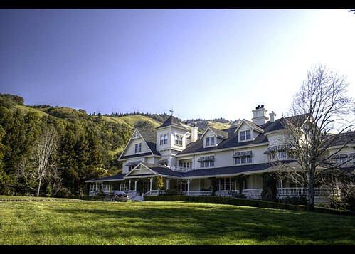
Skywalker Ranch

Skywalker Ranch -- Main House, originally uploaded by mccun934.
This is the main house at Skywalker Ranch where George Lucas works.

Skywalker Ranch is the name of the workplace of film director and producer George Lucas in secluded but open country near Nicasio, California in Marin County. The ranch is located on Lucas Valley Road, although Lucas is not related to the road's namesake, a turn-of-the-century landowner in the area. The Ranch is not open to the public and keeps a low profile from the road.
Assembled parcel by parcel since September 1978, Skywalker Ranch has cost Lucas up to US$100 million, according to the Wall Street Journal. After neighboring ranchers complained that Skywalker Ranch was polluting the environment, Lucasfilm acquired 3,000 acres (12 km²) of adjoining land for a total of over 4,700 acres (19 km²). Only 15 acres (60,000 m²) have been developed.
The Ranch contains a barn with animals, vineyards, a garden with fruits and vegetables used in the on-site restaurant, an outdoor swimming pool and fitness center with racquetball courts, the man-made "Lake Ewok", a hilltop observatory, a 300-seat theater called "The Stag" as well as multiple theater screening rooms, and parking that is mostly concealed underground to preserve the natural landscape. Skywalker Sound was moved onto the ranch in 1987, now occupying the Technical Building. The Main House has a company research library under a stained-glass dome. Skywalker Ranch has its own fire station, which is part of the Marin County Mutual Aid system, and is often called on to assist firefighters in nearby Marinwood.
Skywalker Ranch is intended to be more of a "filmmaker's retreat" than a headquarters for Lucas's business operations. The headquarters of Lucasfilm, Industrial Light & Magic, and LucasArts are located in Lucas's Letterman Digital Arts Center in the Presidio of San Francisco. Lucas does not live on the Ranch.

"A journey of a thousand miles must begin with a single step." -- Lao Tzu Copyright © Demetrios the Traveler

Digg!

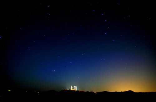
Sounion, Attika Greece


Sounion, originally uploaded by maksid.

The ancient Greek temple of Poseidon in cape Sounion, under the Big Dipper


Παντούμ
Γ.Σεφερης!!!!

Τ᾿ ἀστέρια κρατοῦν ἕναν κόσμο δικό τους
στὸ πέλαγο σέρνουν φωτιὲς τὰ καράβια
ψυχή μου λυτρώσου ἀπ᾿ τὸν κρίκο τοῦ σκότους
πικρή, φλογισμένη ποὺ δέεσαι μὲ εὐλάβεια.

Στὸ πέλαγο σέρνουν φωτιὲς τὰ καράβια
ἡ νύχτα στενεύει καὶ στέκει σὰν ξένη
πικρή, φλογισμένη ποὺ δέεσαι μὲ εὐλάβεια
ψυχή μου γνωρίζεις ποιὸς νόμος σὲ δένει.

Ἡ νύχτα στενεύει καὶ στέκει σὰν ξένη
στὸ μαῦρο μετάξι τὰ φῶτα ἔχουν σβήσει
ψυχή μου γνωρίζεις ποιὸς νόμος σὲ δένει
καὶ τί θὰ σοῦ μείνει καὶ τί θὰ σ᾿ ἀφήσει.

Στὸ μαῦρο μετάξι τὰ φῶτα ἔχουν σβήσει
ἀκούγουνται μόνο τοῦ χρόνου τὰ σεῖστρα
καὶ τί θὰ σοῦ μείνει καὶ τί θὰ σ᾿ ἀφήσει
ἂν τύχει κι ἀστράψει βουβὴ πολεμίστρα.

Ἀκούγονται μόνο τοῦ χρόνου τὰ σεῖστρα
μετάλλινη στήλη στοῦ πόνου τὴν ἄκρη
ἂν τύχει κι ἀστράψει ἡ βουβὴ πολεμίστρα
οὔτε ὄνειρο θά ῾βρεις νὰ δώσει ἕνα δάκρυ.

Μετάλλινη στήλη στοῦ πόνου τὴν ἄκρη
ψηλώνει ἡ στιγμὴ σὰ μετέωρο λεπίδι
οὔτε ὄνειρο θά ῾βρεις νὰ δώσει ἕνα δάκρυ
στὸ πλῆθος σου τὸ ἄυλο ποὺ σφίγγει σὰ φίδι.

Ψηλώνει ἡ στιγμὴ σὰ μετέωρο λεπίδι
σὰν τί νὰ προσμένει νὰ πέσει ἡ γαλήνη;
στὸ πλῆθος σου τὸ ἄϋλο ποὺ σφίγγει σὰν φίδι
δὲν εἶναι ὁ οὐρανὸς μηδὲ ἀγγέλου εὐφροσύνη.

Σὰν τί νὰ προσμένει νὰ πέσει ἡ γαλήνη;
Σ᾿ ἀνθρώπους κλειστοὺς ποὺ μετροῦν τὸν καημό τους
δὲν εἶναι οὐρανὸς μηδὲ ἀγγέλου εὐφροσύνη
τ᾿ ἀστέρια κρατοῦν ἕναν κόσμο δικό τους.

Sunday, July 12, 2009

Temple of Hephaestus and Athena Ergane, Athens Greece


Theseion, originally uploaded by maksid.

On top of Agoraios Kolonos hill, which is delimiting the Ancient Agora of Athens to the west, stands the temple of Hephaestus, broadly known as ?Thisio?. It is one of the best preserved ancient temples, partly because it was transformed into a Christian church. According to the traveller and geographer Pausanias (1, 14, 5-6), two deities were jointly worshipped in the temple: god Hephaestus, protector of all metallurgists, and goddess Athena Ergani, protecting all potters and the cottage industries. The identification of this temple as ?Hephaesteion? (location of worship of the god Hephaestus) was ascertained by the excavations and investigations that brought to light metallurgy workshops on the wider area of the hill, thus outshining earlier opinions presuming that Theseus, Hercules or Aris (Mars) were the deities worshipped there. The temple was probably erected between 460 and 420 BC by a yet unknown architect, to whom, however, are attributed other temples of similar structure in the Attica region.

The temple disposed of a pronaos (anteroom) and an opisthodomos (back section), both distyle (two-columned) in antis. On the exterior it was surrounded by a Doric colonnade having six columns on the narrow sides and thirteen columns on the longer sides. The entire building, from the crepis (stone base) to the roof, was made of marble produced in the quarries of Pendeli mountain (in Attica), while the architectural sculptures that adorned the temple were of marble produced in the quarries on the island of Paros. On the interior of the cella (in Greek sekos) was a two-part colonnade forming the letter Π and at the far end was a pedestal, that supported the bronze ceremonial statues of Hephaestus and Athena, created by the sculptor Alkamenis; according to the traveller and geographer Pausanias, they were probably executed between 421 and 415 BC. The lavish sculptural decoration of the temple featured highly interesting metopes that adorned the east and the west side of the external colonnade. The east side numbered ten metopes that were visible from the Agora: they depicted nine of the feats of Hercules. Furthermore, on the north and the south side are depicted four of the feats of Theseus, which probably were the reason why the people named this temple "Thision". The frieze does not run across all four sides of the cella, but only the across the pronaos and the opisthodomos. The pronaos features the victorious struggle of Theseus against the claimers of the throne, who were the fifty sons of Pallas; six gods also participate into the fight. The opisthodomos depicts the fight of the Centaurs narrated on the wall which is against the cella. Notable sculptural representations also adorned the pediments of the temple. The west pediment depicted the fight of the Centaurs and the east pediment the reception of Hercules on mount Olympus or the birth of goddess Athena. Several among these sculptures inspired statues that were found in the surroundings of the temple, such as the fragmented and partially preserved complex of two feminine figures, one of which transports the other on her shoulders, as if trying to save her life, ("Ephedrismos" = carrying on one's back), Museum of the Ancient Agora, no of finding S 429), or the trunk of a dressed feminine figure where the movement is intensely underlined; the latter could be one of the acroteria (ornamental corner pieces) of the temple ("Nereis" = water deity, Museum of the Ancient Agora, no of finding S 182).

During the Hellenistic period, bushes or small trees in parallel order were planted into flowerpots around the temple; these pots came to light during excavation. In the seventh century AD, the temple was conversed into a church dedicated to St. George Akamas, and thus stayed in use until the liberation of Greece from the Turkish occupation. During the eighteenth century, many eminent Protestants, who died in Athens, were interred in the edifice, while in 1834 it hosted the ceremony of the first reception of king Otto. Hence the temple was used as an archaeological museum, until 1930, when the American School for Classical Studies in Athens started excavations in the Ancient Agora.
Author
Klio Tsoga, archaeologist

Sibiu Romania, Albert Huet Square, Cafe EinStein,

Sibiu - General Information
Location: Central Romania (County: Sibiu)
Size: 46.7 sq. miles (121 sq. kilometers)
Elevation: 1,410 ft. (430 meters)
Population: 170,000
Inhabited since: 300 BC
First documented: 1191 AD

Sibiu (Hermannstadt in German) was the largest and wealthiest of the seven walled citadels* built in the 12th century by German settlers known as Transylvanian Saxons. The riches amassed by its guilds paid for the construction of both impressive buildings and the fortifications required to protect them.

Sibiu’s Old Town retains the grandeur of its earlier days when rich and powerful guilds dominated regional trade. Like Sighisoara and Brasov, it has a distinctly Germanic feeling. Sections of the medieval wall still guard the historic area, where narrow streets pass steep-roofed 17th century buildings with gable overhangs before opening into vast, church-dominated squares such as Great Square and Little Square.
Sibiu is a pedestrian-friendly city with two easily accessible levels: the Upper town, home to most of Sibiu's historic sights, and the Lower town, lined with colorful houses on cobblestone streets and bounded by imposing city walls and defense towers overlooking the river Cibin.

Traditionally, the Upper town was the wealthier part and commercial outlet, while the Lower town served as the manufacturing area. The historical centre includes the Great Square, Huet Square, the beautiful Passage of Steps connecting the upper town to the lower town, the well-known Bridge of Lies, Goldsmiths’ Square and the Small Square.

In 1797, Samuel von Hahnemann opened in Sibiu the world's first homeopathic laboratory

Sibiu is home to the first hospital in Romania (1292), the first pharmacy (1494) and the oldest museum in Romania, the Brukenthal Museum, opened in 1817

The first book in the Romanian language was printed in Sibiu in 1544


"A journey of a thousand miles must begin with a single step." -- Lao Tzu
Copyright © Demetrios the Traveler


Digg!


Thursday, July 9, 2009

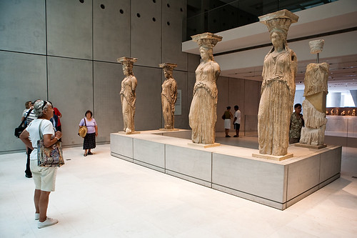
Caryatids of the Erechtheion


Caryatids of the Erechtheion, originally uploaded by macropoulos.
The famous Caryatids, originally from the north porch of the Erechtheion temple (on the Acropolis), as they are now being displayed in the new Acropolis Museum.
caryatid (Greek: Καρυάτις, plural: Καρυάτιδες) is a sculpted female figure serving as an architectural support taking the place of a column or a pillar supporting an entablature on her head. The Greek term karyatides literally means "maidens of Karyai", an ancient town of Peloponnese. Karyai had a famous temple dedicated to the goddess Artemis in her aspect of Artemis Karyatis. en.wikipedia.org/wiki/Caryatid 
"A journey of a thousand miles must begin with a single step." -- Lao Tzu
Copyright © Demetrios the Traveler
readers

labels and tags

Powered By Blogger